7 Chapter 3 Tour de Drones for the Discerning Palate [Nichols]
Student Objectives
To enjoy the range of UAS and UUV technologies by shared stories. At Olive Garden© they call it a “Tour de Italy” This chapter is a “Tour de Drone for the Discerning Palate.” Through stories and vignettes, UAS and UUV world are further discovered.
Introduction
In our three previous textbooks, the authors covered the whole spectrum of UAS / CUAS technologies. (Nichols R. K., et al., 2020)(Nichols, et al., Unmanned Aircraft Systems (UAS) in Cyber Domain: Protecting USA’s Advanced Air Assets, 2nd Edition, 2019)(Nichols R. K., et al., 2019) Every day since our publication have come to market, news about UAS and CUAS technologies have emerged in as many publications and media. In this textbook (4th textbook in the series) the authors have added the unmanned underwater vehicles (UUVs) as technologies based on many of the same autonomous principles working in a different medium. This chapter highlights some of the interesting finds since February 2020 publication of ground-breaking textbook on CUAS. (Nichols, et al., Counter Unmanned Aircraft Systems Technologies and Operations, 2020)
Suspicious Drones?
On 3 August 2020, an interesting poster was received from the Chief of Security at KSU regarding identification of suspicious unmanned aircraft systems (UAS). It was CISA’s Office of Bombing Protection. (Bombing, 2020)
Figure 3.1 is aimed at the protection of national critical infrastructure but has elements common to civilian facilities and personnel protections from a wide variety of threats.
Figure 3.1 Recognize Suspicious UAS
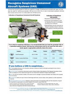
Source: (Bombing, 2020)
The poster shows several interesting items:
Indicators of Suspicious UAS Activity
- Repeated unauthorize flights
- Suspected reconnaissance, such as repeated flyovers or prolonged hovering at low altitudes,
- Testing facility security protocols by flying in sensitive areas to observe the reaction of security personnel (Bombing, 2020)
Easy Acronym – DRONE
Detect all available elements of the situation; attempt to locate and identify the individuals operating the drone ( look at windows, balconies, roof tops)
Report the incident to local LEO and FAA Regional Operations Center.
Observe the UAS and maintain visibility of the device, look for damage or injured individuals.
Notice Features: Identify the type of device ( fixed wing/ multi-rotor), size, shape, color, payload, and activity
Execute appropriate security actions. (Bombing, 2020)
Grounded UAS
Treat a suspicious grounded UAS as a potential explosive threat! (Treat as an IED) (Bombing, 2020)
Figure 3.1 is aimed at / designed for personnel protecting our national critical infrastructure. However, it is just as useful for determining UAS privacy invasions, drug flow and delivery, fraudulent delivery from retailers, residential property casing, stalking, child exploitation, and robberies to name a few possibilities. Treating every downed UAS as an IED is a bit over the top (perhaps) however, better to be cautious because one mistake could cost lives. One the key features of the poster is the “navigation lights taped over or removed” observation. This disabled safety feature can be seen – especially at night – for quite a distance or approximately 500 feet elevation. This is a serious indicator that the UAS is suspicious. (Bombing, 2020)
Cops, Drones and Nudes
From Minnesota comes a strange story. On 31 July 2020 cops in Minnesota flew a drone over a public beach to see if they could spot some exposed females – and then sent seven officers down to ticket topless sunbathers. (Cole, 2020). In response to dozens of complaints regarding nudism, alcohol and drug use, the Golden Valley Police Department used a drone to find people in the nude at Twin Lake, a public beach that’s secluded but popular with locals who want to let it “hang out a little.” The city defended the police citing Covid-19 concerns. The drone was used to “avoid unnecessary face-to-face interactions and the data was used for documentation, evidence collection, and prosecution if need and deleted as soon as possible.” (Cole, 2020)
An ordinance from the Minnesota Park and Recreation Board states that “no person 10 years of age or older shall intentionally expose his or her own genitals, pubic area, buttocks or female breast below the top of the areola, with less than a fully opaque covering in or upon any park or parkway.” (Cole, 2020) (PRBC, 2020) [1] The ordinance has been attacked by a coalition LGBT civil rights activists as discriminating. The author of the article chided the Golden Valley Police Department in her conclusions: “ The fact that the police department—especially around Minnesota, one of the cities at the center of protests against police brutality this year—would break out the most over-the-top means of surveillance and enforcement they could, shouldn’t be surprising.” (Cole, 2020)
All this over a drone!
28,300 feet
Inspired by the 1924 expedition of George Leigh Mallory and Andrew ‘Sandy’ Irvine, National Geographic is working on a documentary titled ‘Lost on Everest.’ Mallory’s remains were found in 1999, but Irvine’s body is still missing. It remains a mystery as to whether the team actually reached the summit before their unfortunate deaths. If they did, it would have been long before Edmund Hillary and Tenzing Norgay reach the top of Mount Everest in 1953. A team from National Geographic surveyed Mount Everest with a drone at 28,300 feet putting the unmanned aircraft in uncharted territory. They flew the drone as high as 28,300 feet or 8,625 meters, just shy of the summit of Mount Everest, which is at 29,000 feet or 8,840 meters, flying the Mavic 2 into ‘uncharted territory.’ Mark Sinnott and Renan Ozturk from National Geographic renewed the search for Irvine’s body and brought with them a DJI Mavic 2 to survey the terrain. With the drone, the team was able to capture sweeping landscape views and close-up photos of key areas of Mount Everest (Figures 3.2, 3.3) (Kesteloo, 2020) [2]

Figure 3.2 National Geographic Climbing Team with Mavic 2 Drone
Source: (Kesteloo, 2020)
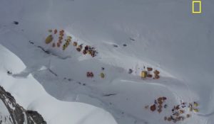
Figure 3.3 Key Search area of Mt Everest
Source: (Kesteloo, 2020)
Turtles
From Mt Everest , we fly 8,313 km (5,165.5 miles) to the Great Barrier Reef. Researchers at Raine Island, the world’s largest green turtle rookery, have used a drone to conduct accurate population surveys, with stunning results. Drone vision captured in December 2019 as part of the Raine Island Recovery Project showed up to 64,000 green turtles around the island waiting to come ashore and lay clutches of eggs. (See Figure 3.4.) Dr Andrew Dunstan from the Department of Environment and Science (DES) and lead author of the paper said researchers had been investigating different ways of conducting turtle population surveys. “New scientific research published on Monday 8 June in PLOS ONE found that drones, or Unmanned Aerial Vehicles (UAVs), were found to be the most efficient survey method,” Dr Dunstan said. “Previous population survey methods involved painting a white stripe down the green turtles’ shell when they were nesting on the beach. The paint is non-toxic and washes off in a couple of days. “From a small boat, we then counted painted and non-painted turtles, but eyes are attracted much more to a turtle with a bright white stripe than an unpainted turtle, resulting in biased counts and reduced accuracy. “Trying to accurately count thousands of painted and unpainted turtles from a small boat in rough weather was difficult. Using a drone is easier, safer, much more accurate, and the data can be immediately and permanently stored.” The drone vision was analyzed, frame by frame in the laboratory, reducing observer error and allowing accurate counts on painted and unpainted turtles. “The ratio of unpainted and painted turtles allowed us to estimate the total population for last December to be 64,000 green turtles waiting to nest on the island,” Dr Dunstan said.
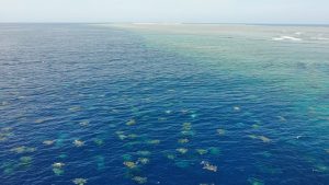
Figure 3.4 Raine-Island-turtle-aggregation
Source: Raine-Island-turtle-aggregation2.-credit-Great-Barrier-Reef-Foundation-and-Queensland-Government-min (1).jpg
“By using drones, we have adjusted historical data. What previously took a number of researchers a long time can now be by one drone operator in under an hour.” “This research is of prime importance to the understanding and management of the vulnerable green turtle population, according to Dr. Dunstan.” (USA weekly, 2020) [3]
Aerobatic Drone
From counting sea turtles’ eggs, we turn our heads to getting air sick as a passenger (not the pilot) in the first manned aerobatic drone flown by the Drone Champions League (DCL). The Drone Champions League (DCL) has been captivating audiences since 2016 with the world’s best pilots of quadcopter racing in head-to-head battles flying drones that can reach speeds of over 160 km/h. It is recognized as the World Championship of professional drone racing. Pilots are chosen by being the best players of the “DCL -The Game” video game. The game can be played by anybody at home, giving everyone the chance to qualify for real-life drone racing events by playing in the DCL Draft Selection.
Now, Drone Champions AG, the creators of the Drone Champions League and DCL – The Game, have revealed their latest innovation: the world’s first manned drone capable of aerobatic maneuvers such as loops and rolls. It was invented by Herbert Weirather, the Drone Champions founder and CEO of DCL. (Steffen, 2020) See Figures 3.5 -3.7.
Dubbed the “Big Drone,” the aircraft is a full-sized, carbon fiber airframe that has six arms protruding from an aerodynamically faired chassis. Each arm has a pair of coaxial rotors mounted at the end. There is a middle seat to carry a passenger, not a pilot. The Big Drone was designed to be flown from the ground by professional drone racing pilots over a remote control. (Steffen, 2020)
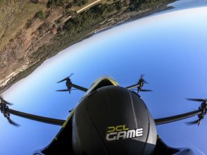
Figure 3.5 “Big Drone” by DCL
Source: (Steffen, 2020)
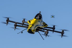
Figure 3.6 “Big Drone” by DCL (2)
Source: (Steffen, 2020)
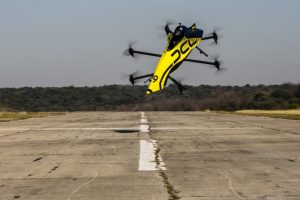
Figure 3.7 “Big Drone” by DCL (3)
Source: (Steffen, 2020)
A very cool flying machine!
Swarm Farming
In our textbook on CUAS we consider drone SWARMS a dangerous threat. (Nichols, et al., Counter Unmanned Aircraft Systems Technologies and Operations, 2020) However, what if we could use it for improving our agricultural outputs. Swarm farming is the concept of using multiple smaller robotic platforms to autonomously conduct farming operations as a substitute to large manned agricultural equipment. (See Figures 3.8 & 3.9) Now, rural agricultural communities have large sections of farmlands and large equipment, which can rapidly cover acres for planting, nutrition, pesticide, and harvesting operations (sometimes involving multiple operations for nutrition and pest control). During a growing season, limited days suitable to work are available to timely complete the specific operation without penalty on yield and profitability. (Precision AG , 2020)
Key drivers for the motivation in swarm farming include decreasing number of people engaged in agriculture, sustainable crop production methods for environmental sustainability, potential negative effects from soil compaction when using larger ag equipment, increasing size of farming operations, and rising average age of U.S. farmers. (Precision AG , 2020)
When it comes to substituting current large equipment with swarm farming, one of the key qualifiers is going to be comparative system productivity and accuracy. There are probably dozens of different types of robotic platforms which have been designed in Europe and the U.S. Some examples include Robotti by Agrointelli, Tertil by Franklin robotics, OZ, and DINO by Naio technologies, TerraSentia by Earthsense, AVO and ARA robots by Ecorobotix, DOT by Raven Autonomy, SwarmFarm Robotics, and BoniRob by Deepfield Robotics. Platform sizes vary from small robots to do scout activities, medium sized for operations like weeding, and some large enough to conduct multi-row operations like spraying and seeding. (Precision AG , 2020)
Most of the robotics platforms currently in sight are standalone with a future vision to operate as swarms. The majority of these robotic platforms are light enough to just conduct non-soil engaging activities, whereas only a few can do soil engaging activities. These platforms are currently shown to operate on crops with low canopy heights (vegetable and fruits), with few exceptions like vineyards. (Precision AG , 2020)
However, there are very few options for row crop operations requiring operation on substantially large acreage, greater draft, and weight transfer. Another interesting facet is that not all of these robotic platforms have been designed with full considerations on implementations or application systems to be utilized in the real-world. Today’s producers use a lot of technology, automation, automatic machine data, and not to mention, the human intelligence sitting inside the machine. One question we need to ask ourselves as stakeholders in the industry is, are farmers ready to provide a practical switch? (Precision AG , 2020)
Currently, there are a handful of swarm farming concepts which are being explored. Robotic platforms, like ones from Swarmfarms, DOT, Naio, Guss and others, are examples of how swarm robots could become reality. Personally, I feel the biggest hurdle we need to cross is the ability of such robotic platforms to operate as a fleet or implement swarm farming on large acres in a representative manner. (Precision AG , 2020)
Swarm farming definitely has some foreseeable advantage, if this swarm fleet becomes fully autonomous in operation over larger fields. Personally, I see two biggest advantages. One, a fully integrated system can reduce operational time spent by farm owners on and off the machines and continuous optimization using machine learning, Two, the automatic decision-based applications using artificial intelligence, data assimilation, and aggregated data availability for analytics are strong assets. Swarm has the ability to operate on its own, detect and communicate faults, automatic reloading of operational boundaries if one platform is down, and many more. (Precision AG , 2020)
The big dream is that platforms within swarm farming will have capability to operate nearly 24/7, but the question is, how far are we from that reality? (Precision AG , 2020)
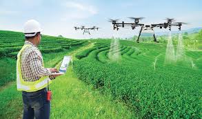
Figure 3.8 Swarm Farming -Spray Operations
Source: https://www.silicon-saxony-day.de/

Figure 3.9 Swarm Farming – Land Survey Operations
Source: https://pt.wikipedia.org/wiki/Ficheiro:Aerial_View_-_Landschaft_Markgr%C3%A4flerland1.jpg
COVID-19
It is an understatement that Covid-19 pandemic has affected millions of lives globally. However, a company called SkySkopes is doing something positive in the midst of chaos.
Unmanned aerial systems (UAS) are being studied as tools to fight the novel coronavirus. (See Figure 3.10 sprayer for disinfectant) The UAS will be used to disinfect large public areas and to deliver supplies. In Grand Forks, N. Dakota, SkySkopes, a UAS flight operator that serves a wide variety of industries; the Center for Innovation at the University of North Dakota (UND); and a number of other companies are engaged in a study to determine how drones can be used to accomplish these tasks. (Zimmer, 2020)
SkySkopes is also testing the use of thermal sensors that are positioned in stationary locations above research participants. The sensors detect elevated temperatures and help ensure that an individual is healthy enough to return to work. Like Syracuse-based drone startup EagleHawk, SkySkopes is determining what methods can be used to disperse disinfectant effectively and on a large scale. Since mid-March, the company has been making test runs, spraying public playgrounds using nozzles and tanks. The only substance SkySkopes has sprayed outdoors is water. When its UAS have been used indoors, they have sprayed a solution of 3 percent hydrogen peroxide and 97 percent water. (Zimmer, 2020) [4]
SkySkopes is also developing procedures for drone pilots and visual observers to travel to and from a site, and to clean instruments before, during and after use, and take measures to inform and protect the public. SkySkopes CEO Matt Dunlevy said that reconsidering the use of drones during the pandemic requires identifying new precautions and protocols. (Zimmer, 2020)
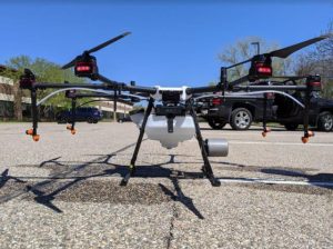
Figure 3.10 SkySkopes Covid-19 Disinfectant sprayer drone
Source: (Zimmer, 2020)
“One of our biggest questions is what we will need to do to discourage crowds who want to observe our work from forming. We do not want to exacerbate community spread as we disinfect public spaces,” said Dunlevy. (Zimmer, 2020)
Dunlevy added that while playgrounds are not the only target site being considered, they are good locations to conduct research. “We’re using them to learn how to disinfect many other objects and areas, including vehicles, the outsides of different types of buildings, park equipment, and indoor spaces such as movie theaters and gymnasiums,” said Dunlevy. (Zimmer, 2020)
Fortunately, playgrounds are ideal for study because they contain a number of complex elements that can indicate how to tackle similar areas in other outdoor workplaces. For instance, SkySkopes has a number of clients in the energy industry, where ladders and platforms are present, and crowds are unavoidable for project executions. (Zimmer, 2020) (See Figure 3.11 SkySkopes Playground Test Area)
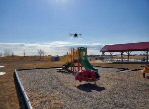
Figure 3.11 SkySkopes Playground Test Area
Source: (Zimmer, 2020)
Dunlevy explained that smaller areas could be disinfected with a single payload of liquid carried on the drone and released by “one fell swoop” of a drone pilot. Larger areas could be disinfected with liquid drawn from a tank on the ground by an assistant, carried to the drone by a tube, and sprayed out of a nozzle attached to the tube. A tank-and-hose combination could also be effective at disinfecting the underside of elements like monkey bars. The drone could fly under the play structure and turn the nozzle to spray disinfect upwards.
Currently, SkySkopes is running thermal sensor tests with Infrared Cameras Inc.’s Optical Gas Imaging camera, which is made with components by FLIR Systems, Inc., on DJI’s Zenmuse XT. SkySkopes expects real-life use of the sensors could involve mounting the device on the wall of a hospital or care facility, with an employee standing under the device to take a reading. (Zimmer, 2020)
“Right now, we’re just testing out use of that on the ground. We are only testing it on SkySkopes employees and research participants. As for nozzles for drone spraying, we are testing out a combination of different spray nozzles and tanks. We’re borrowing heavily from already-proven techniques in agriculture,” said Dunlevy. (Zimmer, 2020)
Mark Askelson, a professor of atmospheric sciences and executive director of the Research Institute for Autonomous Systems (RIAS) at the University of North Dakota, is assisting with the study. Askelson said the studies indicate that a spray of very small drops of disinfecting liquid would likely limit the fluid’s ability to kill the virus. “The smaller the droplet, the faster it evaporates. That is the reason SkySkopes is out there under different conditions to determine how drop size, wind speed, and direction affect coverage,” said Askelson. Askelson noted that determining the “residence time” of droplets of cleaning fluid is important to determine whether the drops stay on the surface of an object long enough to kill the virus. (Zimmer, 2020)
HAPS UAV – Stratospheric Test Flights
In our CUAS textbook, we covered the failed promises of HAPS technology using UAVS. (Nichols, et al., Counter Unmanned Aircraft Systems Technologies and Operations, 2020) However, there is progress.
HAPSMobile has successfully completed the fourth test flight of its Sunglider solar-powered high-altitude pseudo-satellite (HAPS) unmanned aerial vehicle (UAV). The test flight took place at Spaceport America in New Mexico, and its completion marks the conclusion of all basic aircraft tests for the aircraft. HAPSMobile will now begin preparations for stratospheric test flights. (UST Weekly eBrief, 2020) (See Figure 3.12)
During this round of testing, Sunglider reached altitudes higher than those of previous flights and maintained high altitudes for a long duration. Other test milestones included flight speed changes, steep turns, automated flight control in the event of interrupted communications with the Ground Control System, and in-flight balance control. (UST Weekly eBrief, 2020)
HAPSMobile has constructed a new specialized test site at Spaceport America, providing an additional facility to the existing test site on the Hawaiian island of Lanai. Spaceport America offers flexibility in coordinating test flight schedules, providing opportunities to conduct test flights with greater frequency and more freedom to conduct various types of tests. HAPSMobile also plans to conduct stratospheric test flights at Spaceport America. (UST Weekly eBrief, 2020)
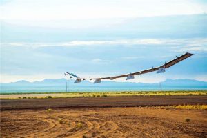
Figure 3.12 HAPS Sunglider
Source: (UST Weekly eBrief, 2020)
Drones to Deliver Organ Transplants
Drones are slated to be the ideal technology to deliver organs to transplant patients—and a test program could soon make this premise a reality. Dr. Joseph Scalea, transplant surgeon at the University of Maryland Medical Center, is working with a group of researchers to explore if drones are a suitable method for transporting organs . The team recently concluded a series of 14 test flights that demonstrate the potential for drones to work as organ couriers. (Greenwood, 2019)
The team used a DJI M600 Pro drone for the experiment. See Figure 3.13. Its six motors lie directly below their respective rotors—and further away from its cargo, a smart cooler that contains an organ, reducing the organ’s exposure to heat from the robot’s motors. The team also designed a wireless biosensor that measures the organ’s temperature, barometric pressure, altitude, vibration, and GPS location while it is being transported. Finally, the team used a kidney that was not a viable transplant to test its drone. (Greenwood, 2019)
Figure 3.13 DJI M600 Pro for Organ Transplant
Source: (Greenwood, 2019)
The results, published by the IEEE, show the test was a success. [5] Biopsies of the kidney before and after the flight showed it remained undamaged. The temperature of the kidney remained at a stable 2.5°C, the air pressure matched the altitude, and the drone flew up to 67.6 kph. The kidney was even subjected to marginally fewer vibrations than it would have been exposed to on a fixed wing plane. (Greenwood, 2019)
Organs do not last very long outside the body, which means they must get to their intended recipients as soon as possible—often on short notice, making every second critical. But the current organ transport system relies on couriers, commercial airline schedules and expensive charter flights. Any delay or mistake during this process could mean the organ loses its effectiveness—or deteriorates so much that it cannot be used at all. (Greenwood, 2019)
These costs and mistakes could be reduced by using drones. “It will be faster and cheaper and more predictable,” said Scalea. There are regulatory obstacles to overcome. The FAA strictly enforces limits on drone use, but the agency is planning to make changes based on data from 10 pilot programs—two of which plan to transport medical supplies. Those changes would make it possible for drones to make the organ transportation system—which supplies organs for more than 30,000 transplants a year—faster and more efficient. “Drones really work for this purpose,” said Scalea. (Greenwood, 2019) See Figure 3.14.
Figure 3.14 Organ Transplant coming in for landing at Hospital
Source: (Greenwood, 2019) https://spectrum.ieee.org/image/MzE3NTIwOA.gif
Robot Trucks?
The author is all for expanding the uses of drones in the transportation theater. But Robot trucks? Respectfully, this is a horrible idea. Living near a major trucking thoroughfare in Pennsylvania with 50+ huge trans-shipment / storage complexes off I-81 /, where real semi-trucks going North and South at a rate 100,000 + per hour along with triple that number in regular cars moving about 70 mph pile up the accidents (many fatal) every single day. This is with drivers that understand human nature, road rage, tailgating and impaired drivers have an advantage. Add to this mess robotic, autonomous, computer algorithm-based vehicles with lots of momentum and weight, portends a huge risk to public transportation. [6]
However, TuSimple, a self-driving startup with operations in the U.S. and China,[7] is opening what it calls the world’s first “Autonomous Freight Network,” a highway corridor stretching over 1,100 miles from Phoenix to Houston for its robot trucks to haul loads in a technology partnership with UPS, U.S. Xpress, Penske Truck Leasing and Berkshire Hathaway. The project involves the San Diego-based company’s fleet of 40 self-driving semis (with human safety drivers in the cab), new proprietary software for TuSimple and its customers to monitor their on-road performance and location data, high-definition digital route maps and freight terminals at strategic locations.
TuSimple will haul revenue-generating loads for UPS and foodservice McLane as well as new customer U.S. Xpress on routes throughout the network–with Penske helping to maintain the trucks–and the partner firms can learn how to integrate robotic trucks into their operations. (Ohnsman, 2020)
If all goes as planned, TuSimple will expand the network from Los Angeles to Jacksonville, Florida, along U.S. Interstate-10 by 2022 and then start operating Level-4 self-driving truck services across the U.S. by 2023. “The network is the first of its kind to address how you can bring autonomy to the market at scale,” TuSimple President Cheng Lu tells Forbes. (Ohnsman, 2020)

Figure 3.15 TuSimple Autonomous Truck
Source: (Ohnsman, 2020)
Can you be sued for flying a Drone over Private Property – The New Tort Law
The draft of the proposed tort law relating to drones, due to be discussed by the Uniform Law Commission (ULC) soon, is out – and drone operators should be paying very close attention. What is Tort Law, and Who is the ULC? Why is this new Tort law important to drone owners?
The definition of “Tort,” according to the Cornell Legal Information Institute, is “an act or omission that gives rise to injury or harm to another and amounts to a civil wrong for which courts impose liability,” and the point of a tort law is “to provide relief to injured parties for harms caused by others, to impose liability on parties responsible for the harm, and to deter others from committing harmful acts.” That relief, says the Institute, is typically, “damages in the form of monetary compensation.” (McNabb, 2019)
The ULC, by their own definition, “provides states with non-partisan, well-conceived and well-drafted legislation that brings clarity and stability to critical areas of state statutory law.” ULC is proposing a tort law relating to drones, which would give homeowners the right to sue drone operators for flying over their private property under certain conditions. (McNabb, 2019) See figure 3.16.
Figure 3.16 Drone footage over a private house and barn
Source: (McNabb, 2019)
Background on the Tort Law Relating to Drones – Draft One
The first draft of the tort law drew nearly universal condemnation from the drone industry. According to one expert “If the draft Act became law, the mere presence of a drone in the airspace up to 200 feet over private property would be, by definition, injuring the landowner and committing aerial trespass. Essentially, the draft Act does not recognize a distinction between a drone which harasses the property owners by hovering feet from a window and a drone, operated by a certificated professional, hovering one foot inside a neighbor’s property line to snap a photo of an adjacent property.” That draft received many comments from drone industry stakeholders and failed to pass when the ULC met to discuss it. (McNabb, 2019)
The New Draft
The new draft does attempt to address some of the issues found in the first draft: for example, it creates a more narrow definition of aerial trespass that includes the terms “substantial interference with the use and enjoyment of the property,” and defines “substantial interference.” The new draft also includes clauses about the accidental or unavoidable landing of a drone on private property and specifies that landowners must return a drone that lands on their property to the operator. This proposal has such potential to materially impact legitimate drone operation that it behooves drone operators to take the time to educate themselves. (McNabb, 2019)
See additional quoted verbiage below from the new proposed ULC draft Tort law relating to drones. (McNabb, 2019)
Definition of “Airspace Intrusions” from the draft:
SECTION 5: AIRSPACE INTRUSIONS.
(a) An aerial trespass occurs when a person intentionally and without consent of the landowner operates an unmanned aircraft in the airspace over the landowner’s property and by so doing causes substantial interference with the use and enjoyment of the property.
(b) The determination of whether an unmanned aircraft’s operation over property has caused substantial interference with the use and enjoyment of property shall be based upon a review of the totality of the circumstances, including:
(1) The amount of time the unmanned aircraft was operated over the landowner’s property.
(2) The altitude at which the unmanned aircraft was operating.
(3) The number of times unmanned aircraft have been operated over the property.
(4) Whether the unmanned aircraft recorded or captured audio, video, or photographs while in operation over the property.
(5) Whether the landowner has regularly allowed operation of unmanned aircraft over the property.
(6) Whether the operation of the unmanned aircraft caused physical damage to persons or property.
(7) Whether the operation of the unmanned aircraft caused economic damage.
(8) The time of day the unmanned aircraft was operated over the landowner’s property.
(9) Whether an individual on the land saw or heard the unmanned aircraft while it was over the property; and,
(10) The operator’s purpose in operating the unmanned aircraft over the property.
(c) Repeated or continual operation of an unmanned aircraft over a landowner’s property shall not give rise to prescriptive rights in the airspace
Definition of “Intrusions on Land”:
SECTION 6: INTRUSIONS ON LAND.
(a) Except as provided in subsection (b), a person who, without permission, intentionally lands an unmanned aircraft on the land of another, or who intentionally causes an unmanned aircraft to come into physical contact with a structure, plant life, or individual on the land of another, commits a trespass to land.
(b) A trespass to land does not occur under subsection (a) when:
(1) the unmanned aircraft operator is forced to land the unmanned aircraft because of unexpected circumstances that reasonably justify such a landing; or,
(2) the unmanned aircraft malfunctions or otherwise touches down upon the surface of the land because of weather or other factors beyond the operator’s control.
(c) A person asserting the privileges provided in subsection (b) is liable for any damage caused by the unmanned aircraft’s operation.
(d) Regardless of how an unmanned aircraft came to rest upon the property of another, the owner or operator of the unmanned aircraft has a right to recover the unmanned aircraft upon a request to the owner of such property. A landowner shall not unreasonably refuse a request to return the unmanned aircraft or to permit the unmanned aircraft’s operator to recover the unmanned aircraft from the property.
Definition of “Violations of Privacy”:
SECTION 8: UNMANNED AIRCRAFT AND VIOLATIONS OF PRIVACY.
(a) Privacy related civil actions may be based upon the operation of an unmanned aircraft.
(b) A determination of whether an unmanned aircraft’s operation over property was used to violate a privacy-related right shall be based upon a review of the totality of the circumstances, including:
(1) Whether by hovering or repeated flights the unmanned aircraft was likely to have provided the operator with the opportunity to use the unmanned aircraft to view, listen to, record or capture by camera, microphone or other device, individuals who were present at that place and time; and,
(2) Whether the operator made statements or took other overt actions indicating a desire to use an unmanned aircraft to infringe upon rights of privacy recognized in this state.
The full draft of the proposed Tort law on drones (which is still being debated) can be obtained at this link: https://www.uniformlaws.org/viewdocument/march-2019-committee-meeting-draf-1?CommunityKey=2cb85e0d-0a32-4182-adee-ee15c7e1eb20&tab=librarydocuments (McNabb, 2019)
Drone owners should take note of above. This may be the restrictive direction that drone tort law is heading.
GPS Interference crashes drone in UK – Ligado debate rages
Staying on the trend of legal interest, the next story is about GPS interference crashing a survey drone in the US. An expensive drone crashed into a house in December when it lost GPS signals due to interference, according to an accident investigation by the United Kingdom. The drone, a DJI M600 Pro was surveying a construction site when the mishap occurred. The DJI M600 Pro can weigh as much as 34lbs (15.5kg) and is listed at $5,699 on the vendor’s website. (Goward, 2020)
According to D.A. Goward ( (Goward, 2020), The mishap has given added impetus to those in the United States opposed to the Federal Communications Commission (FCC) decision to allow Ligado Networks to transmit on a frequency near to that of GPS. U.S. government tests have shown that high precision GPS receivers, like those used on some survey drones, may not have reliable signals whenever they are within 3,400 meters (2+ miles) of a Ligado transmitter. Drones with less precise, general purpose GPS receivers could be impacted within 1,040 meters (.6 miles).
Drones with unreliable GPS can wander into areas they are not allowed and eventually crash. The larger and heavier the drone, the more dangerous this can be. Most commercial drones are less than 100 lbs (45kg), though some models can weigh in at 200 lbs (90 kg) or more. While drones are supposed to remain within the line of sight of the operator, when GPS navigation is lost, many enter an “attitude mode.” This results in the aircraft maintaining its height above the ground and its wings level using on-board barometric and inertial sensors. It cannot hold its position over the ground though, without GPS and so will drift with the wind. Unless the operator takes manual control right away the drone can drift out of the operator’s sight. That usually also means it is unable to receive radio commands sent by the operator. (Goward, 2020)
This is precisely is what happened in this case, according to the UK’s Aircraft Accident Investigation Board’s report. A survey of a construction site by drone was in its second day. The first three flights were without incident. On the fourth flight the drone took off and reached about 65 feet above the ground. The pilot’s controller then showed a GPS compass error. At that point, the drone stopped climbing and began drifting away in the wind at about 15 miles per hour. The pilot repeatedly selected the “return home” function to no avail before the aircraft flew beyond a line of trees and was out of sight. It hit the roof of a home several hundred yards beyond the trees and crashed in the backyard. (Goward, 2020)
After notifying police of the missing drone, the pilot prepared another drone to search for the lost one. However, shortly after takeoff, the controller again showed a signal‑interference error message and the pilot immediately landed it. The accident report’s analysis cites signal interference with GPS as cause of the malfunction of the drone that crashed and the second one that was to look for it. It says the source of the interference was not identified. The report also observes that serious injury or death could have resulted. (Goward, 2020) The report indicates:
“… analysis indicated that a mass of more than 2 kg falling from the roof of the house could have resulted in a serious or even fatal injury to people if they had been struck. The aircraft mass, at 12.8 kg, was well in excess of this figure and therefore it is very likely that serious injuries would have occurred even if the person struck was wearing a hard hat for protection.” (Goward, 2020)
Aviation interests in the United States had for years opposed the FCC granting Ligado Networks’ application. Despite this and the formal and strong opposition of the executive branch of government, the FCC approved Ligado’s request in April. The FCC’s approval of Ligado Network’s application has not silenced opposition. Rather it has caused opposition to spread across many industries and sectors. Vocal opponents now include agricultural, maritime, vehicle and industrial interests.
Legislation is under consideration in Congress that would cause the FCC’s decision to be re-examined and prevent the Defense Department from doing business with any company that interferes with GPS signals. Some proposals would put a hold on the FCC’s approval. While the drone mishap in the United Kingdom can be seen as a relatively minor event, as a portent of things to come, it is MIGHT [8] have a huge impact in the United States. (Goward, 2020)
Time to move from air to sea – specifically UUVs.
Autonomous Underwater Glider
Teledyne Marine’s Slocum G2 Glider autonomous underwater vehicle (AUV) has completed a four-part circumnavigation of the Atlantic Ocean that lasted for over four years. The glider, named Silbo, covered a total of 22,744 km and spent approximately 1,273 days at sea. The trip is the first such journey to ever be undertaken by an AUV. (Ball, Autonomous Underwater Glider Circumnavigates Atlantic Ocean, 2020) See Figure 3.17
Over the four legs of its journey, Silbo interacted with international science teams from several countries, and collected scientific and critical engineering data for a variety of programs. During its three stops, the glider received repairs to a scratched hull, an external cleaning, and a fresh set of batteries, and required no other maintenance. (Ball, Autonomous Underwater Glider Circumnavigates Atlantic Ocean, 2020)
Following a factory upgrade to install an extended energy bay and thruster in preparation for its voyage, Silbo was launched in the early spring of 2016 from Cape Cod, Massachusetts. The first leg of its journey took it from Cape Cod to Ireland, covering a distance of 6557 km in 330 days. While in Ireland, Silbo participated in a Glider Training session hosted by the Marine Institute and P&O Maritime Services, Galway. (Ball, Autonomous Underwater Glider Circumnavigates Atlantic Ocean, 2020)
Figure 3.17 Teledyne Marine’s Slocum G2 Glider autonomous underwater vehicle (AUV)
Source: (Ball, Autonomous Underwater Glider Circumnavigates Atlantic Ocean, 2020)
On the second leg, Silbo travelled from Ireland to the Canary Islands, covering 3695 km in 178 days, and participated in a “glider school” at the research facility Oceanic Platform of the Canary Islands (PLOCAN) and the University of Las Palmas de Gran Canaria (ULPCG). The third leg lasted 418 days, taking Silbo from the Canary Islands back across the Atlantic to St. Thomas, U.S. Virgin Islands, gliding 6256 km. Supported by staff and students from University of the Virgin Islands (UVI), St. Thomas, Teledyne technicians recovered, re-batteried and re-deployed Silbo in less than 24 hours. (Ball, Autonomous Underwater Glider Circumnavigates Atlantic Ocean, 2020)
Silbo’s fourth and final journey from St. Thomas began on July 18, 2019 and concluded on June 29, 2020 south of Martha’s Vineyard, completing the final 6236 km trek in 348 days. During this transit Silbo spent three months flying a butterfly pattern south of Bermuda contributing data to Bermuda Atlantic Time-series Study (BATS). Silbo then joined the Gulf Stream, becoming the season’s first storm glider as Tropical Storm Arthur passed directly over the glider. (Ball, Autonomous Underwater Glider Circumnavigates Atlantic Ocean, 2020)
During this circumnavigation, Silbo collected hurricane data, corrected current models, and provided close to 5000 CTD (conductivity, temperature, and depth) casts that aided meteorological forecasting. With partners from Rutgers University and its student base, UVI, PLOCAN, UGCLP, the Marine Institute, and others, Silbo also participated in the Challenger glider mission. Silbo has also been used as a test bed for many new engineering hardware and software features for both existing and next generation Slocum gliders. Recent legs have provided data on new battery configurations, advanced software, and techniques for piloting long endurance missions and minimizing biofouling. (Ball, Autonomous Underwater Glider Circumnavigates Atlantic Ocean, 2020)
Very cool![9]
New Autonomous Guard USV
Author Mike Ball gives us another cool view. This time for a new autonomous Guard USV unveiling.
A design for a new unmanned surface vessel (USV) concept, created by Sea Machines and a consortium of partners including C-Job Naval Architects, LISA Community, Seazip Offshore Service, Maritime Research Institute Netherlands (MARIN) and eL-Tec Elektrotechnologie, has been unveiled. The Autonomous Guard Vessel (AGV) is designed to provide a small, lighter, and more efficient alternative to current manned guard vessels used to protect maritime and offshore operations such as wind farms and cabling routes. (Ball, New Autonomous Guard USV Unveiled, 2020) See Figure 3.18.
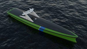
Figure 3.18 Sea Machines USV Concept
Source: (Ball, New Autonomous Guard USV Unveiled, 2020)
The AGV can continuously monitor nearby marine traffic visually as well as via radar and AIS (automatic identification system) data, taking measures to secure the area in order to avoid collisions and damage to offshore infrastructure. The USV will attempt communications with any vessel that approaches the area, providing information on how to safely navigate the area as well as physical escort away from the site. The encounter will be recorded to provide video footage in case of any violation or accident. (Ball, New Autonomous Guard USV Unveiled, 2020)
As the autonomous platform does not require an onboard crew, it is considerably smaller than equivalent manned guard vessels. This lowers the operational cost and also allows it to be sustainably powered by batteries, which can be recharged via a charging station. This station can be moored independently or connected to existing onsite equipment, such as an offshore transformer platform. Depending on the situation, charging could be performed either via a cable connection to the on-site equipment, or locally generated using renewable fuels. (Ball, New Autonomous Guard USV Unveiled, 2020)
The consortium envisions that a typical offshore site will require a number of AGVs, which can take turns in monitoring the area and recharging. In addition to autonomous operation, remote control is also being considered for the vessel, in order to deal with situations that require human intervention. The AGV would be connected to a command center on a mothership or at a shore-based location, where a human operator will control the AGV remotely to ensure correct action is taken. In addition, all data collected by the AGV will be sent to the command center. (Ball, New Autonomous Guard USV Unveiled, 2020)
Frank Relou, business development manager at Sea Machines, stated: “Smart vessel technology will have the most significant initial impact on small workboats, such as this guard vessel. The development of autonomous technology for vessel operations are occurring on an international level but namely in niche segments, such as the guard vessel and other examples, currently operating in (with supervised autonomy), marine survey, fire, patrol, aquaculture and offshore wind operations[10].” (Ball, New Autonomous Guard USV Unveiled, 2020)
Protecting Undersea Cables – A National Security Priority
Nadia Schadlow and Brayden Helwig [11]of Defense News (opinion) present a compelling national security case for protecting data transiting via underseas cables. (Schadlow & Helwig, 2020)
Data is arguably the most important strategic asset to emerge in the 21st century. Access to data and the ability to protect its integrity are vital to American security and prosperity. As 5G and artificial intelligence transform our societies into highly integrated networks, protecting data will become even more crucial. In recent years, American efforts have focused on preventing Huawei, the party-controlled Chinese telecommunications giant, from gaining ground as the world’s largest supplier of 5G infrastructure. But defending a less understood part of our digital infrastructure — undersea fiber-optic cables — should be an equal priority. Without the approximately 750,000 miles of cables that crisscross the world’s oceans, our interconnected, digitally driven societies would be unable to function. (Schadlow & Helwig, 2020)
In 1858, when the first submarine cable was installed, sending a message across the Atlantic took nearly 18 hours. Today, the fastest undersea cables can transfer data at speeds upward of 25 terabytes per second — more than twice the amount of data generated by the Hubble Space Telescope each year.
Undersea cables make instant communications possible, transporting some 95 percent of the data and voice traffic that crosses international boundaries. They also form the backbone of the global economy — roughly $10 trillion in financial transactions are transmitted via these cables each day. And undersea infrastructure is not just for civilian use. The U.S. government relies on cables to transmit information. (Schadlow & Helwig, 2020)
America’s competitors consider undersea cables strategically significant. Tapping undersea cables could provide foreign leaders with valuable intelligence, while severing cables could slow communications between the U.S. and its NATO allies significantly — perhaps by even months. (Schadlow & Helwig, 2020)
Data can also be siphoned from undersea cables. This is most easily done during the cable manufacturing process, when backdoors could be inserted to collect information. Similar vulnerabilities exist at onshore landing stations, where cables connect to terrestrial networks. Cables can be tapped at sea, though this is relatively difficult to do. (Schadlow & Helwig, 2020)
Russia and China have developed capabilities in these areas. Russian submarine activity near undersea cables is well-documented: The Yantar, a Russian spy ship, carries mini submersibles that can either sever or tap them. Russian activity often clusters around crucial, yet hard-to-reach cables because these are difficult to repair. (Schadlow & Helwig, 2020)
Chinese officials view control of undersea infrastructure as part of a broader strategic competition for data. One official Chinese Communist Party outlet explained that “although undersea cable laying is a business, it is also a battlefield where information can be obtained.” Huawei Marine, a Huawei subsidiary, is a major player in the undersea cable industry. The company has built or repaired almost a quarter of the world’s approximately 400 submarine cables. But American officials worry that cables laid or serviced by the company may be accessed by the Chinese government. In 2019, amid increasing scrutiny from the U.S. and its allies, Huawei sold its subsidiary to Hengtong Optic-Electric, a Chinese fiber and cable manufacturer. But the sale failed to alleviate national security concerns: Hengtong’s director and founder is a Chinese government official. (Schadlow & Helwig, 2020) China could also integrate undersea cable disruption into its military strategy. Last year, a Taiwanese think tank warned that in the early stages of a Chinese invasion of the island, the People’s Liberation Army may sever Taiwan’s undersea cables, isolating it from the U.S. and regional allies. (Schadlow & Helwig, 2020)
Protecting undersea cable infrastructure must become a priority for U.S. officials and lawmakers. According to Schadlow and Helwig, there are several steps they can take to address the problem.
First, the U.S. government should take more responsibility for repairing undersea infrastructure. Currently, cable repairs are considered a commercial responsibility, rather than a national security concern. Classifying cable repairs as matters of national security and developing a public-private operational plan — that includes a division of resources — to repair them is one step toward reducing the response time to a disruption or an attack. (Schadlow & Helwig, 2020)
Second, as a 2017 report from the Office of the Director of National Intelligence suggested, the U.S. should push for stronger protections for undersea infrastructure in international law, including criminalizing attacks on submarine cables. These efforts should be coordinated closely with America’s allies, especially those in Europe and East Asia. (Schadlow & Helwig, 2020)
Third, telecommunications companies must better secure cable infrastructure against potential attacks. Companies such as Google, Microsoft, Facebook, and Amazon now own or lease nearly half the world’s undersea bandwidth. Companies could begin by securing cable landing stations, while investing in technologies that detect and deny undersea espionage. The executive branch could consider tax incentives to spur these steps. (Schadlow & Helwig, 2020)
Finally, the Trump administration should sound a louder alarm on Huawei Marine. In order to reduce or prevent the exfiltration of data, telecommunications companies should be required to use undersea infrastructure from verified suppliers. At the very least, owners of data transmitted this way should be aware of the undersea path their data is taking — and potential vulnerabilities. Ultimately, undersea cables help keep Americans connected, prosperous and safe. Protecting them from sabotage and espionage is a vital national security interest of the United States. (Schadlow & Helwig, 2020)
Navy Large Unmanned Surface and Undersea Vehicles: Background and Issues for Congress
Although too large to summarize in this chapter, the author would like to bring to attention a report to congress by Ronald O’Rourke, Specialist in Naval Affairs entitled: Navy Large Unmanned Surface and Undersea Vehicles: Background and Issues for Congress, R45757. It can be found at: https://fas.org/sgp/crs/weapons/R45757.pdf (O’Rourke, 2020)
This report provides background information and potential issues for Congress for three types of large unmanned vehicles (UVs) that the Navy wants to develop and procure in FY2021 and beyond:
- Large Unmanned Surface Vehicles (LUSVs).
- Medium Unmanned Surface Vehicles (MUSVs); and
- Extra-large Unmanned Undersea Vehicles (XLUUVs).
The Navy wants to acquire these large UVs as part of an effort to shift the Navy to a new fleet architecture (i.e., a new combination of ships and other platforms) that is more widely distributed than the Navy’s current fleet architecture. The Navy is requesting $579.9 million in FY2021 research and development funding for these large UVs and their enabling technologies. (O’Rourke, 2020)
The issue for Congress is whether to approve, reject, or modify the Navy’s acquisition strategies and FY2021 funding requests for these large UVs. The Navy’s proposals for developing and procuring them pose a number of oversight issues for Congress. Congress’s decisions on these issues could substantially affect Navy capabilities and funding requirements and the shipbuilding
and UV industrial bases. (O’Rourke, 2020)
In addition to the large UVs covered in this report, the Navy also wants to develop and procure smaller USVs and UUVs, as well as unmanned aerial vehicles (UAVs) of various sizes. Other U.S. military services are developing, procuring, and operating their own types of UVs. (O’Rourke, 2020) The O’Rourke is a treasure trove of USN design, architecture, and strategic information.
Drone Sightings: The Actual Non-Hyped Numbers Analyzed
On Linkedin via sUAS News, a solid report by Jonathan Rupprecht popped up on 5 August 2020 exposed the disinformation, double counting and misinformation about drone sightings based on analyses of six (6) years of reported data from FAA and local government data / reports. It is an eye-opening report! (Rupprecht, 2020) Here is a summary of findings:
Background
For years and years, many have been talking about the FAA’s drone sightings reports. The drone sightings reports have been cited many times by the news media and elected officials who were rather alarmed about the data. Others in the industry cite the drone sightings as evidence of the greater need for the government(s) to do something by creating regulations. Some counter-drone companies have used it to show a need for their product. Others say it is hype and the sightings data is greatly flawed and overblown because after all, they are only sightings, not impacts.
Regardless of where you come from in the industry and your motives, we need to accurately understand the drone sightings data. The report critically considers the growth of drone sightings, where they typically are located, and whether the data is alarming as many have said. (Rupprecht, 2020)
Quick Summary of the Drone Sightings:
- The reported drone sightings over time are NOT growing. They are decreasing.
- The FAA has inaccurately reported on the drone sightings data and this is proven by their own data they released(more on that later).
- There are more drone sightings reported in populated areas than unpopulated areas.
- There are more drone sightings reported in warmer months than colder months.
- States with larger populations have more reported drone sightings.
- There are more medium or large animal impacts with manned aircraft than mere reported drone sightings.
- Any discussions we have on this topic should be using numbers and not just percentages or words. (Rupprecht, 2020)
Basically, population and weather/climate are the determining factors of when and where you will have drone sightings. The data also shows that we are past a peak in sightings and they are currently consistently decreasing. But how many of these sightings are verified sightings of drones and not white balloons, seagulls, etc.? (Rupprecht, 2020)
How many of these reported sightings are of drones actually flying unlawfully, dangerously, or nefariously? Is there like a giant 🙁 face on the drone that tells you it is bad? A drone being flown by a good guy and one being flown by a bad guy are extremely difficult to tell apart. (Rupprecht, 2020)
What Does the Word “Sighting” Mean?
Sightings are just that….mere sightings. A pilot, person on the ground, law enforcement officer, etc. sees a drone and reports it to the FAA. It gets logged. The drone could be lawfully flying, safely flying, carelessly flying, or flying with criminal intent. It is all lumped into one thing – a sighting.
“The accuracy of the reports cannot be verified. You could report you saw a drone all you want. No one can check. It is literally a giant hearsay list. And here is a very thought-provoking question….is there any way we can prevent people who would stand to benefit from higher drone sighting numbers from calling in false sightings? Who is to stop the FAA employees, FAA contractors, people working in counter UAS industry, or manned pilots from calling in more sightings that cannot be verified? Who is to stop over reporting where anything just gets reported as a drone?” (Rupprecht, 2020)
“Keep in mind that 18 U.S.C. 1001 makes it a criminal offense to make false statements to the FAA so many will be deterred from doing that. Some of the reports have identifiable information so they are not really anonymous and less likely to false report. On the other hand, the Department of Transportation’s Inspector General’s Office does investigate FAA officials for illegal activity and police arrest people all the time for fraudulent activity.” (Rupprecht, 2020)
“Provide what weight you will to the sightings. We are in a predicament. There is no evidence to prove that any of those groups reported falsely, but there is also no evidence to prove that everyone reported truthfully AND accurately. We need to be balanced in approaching this data.” (Rupprecht, 2020)
The rest of the Rupprecht report analyzes data from multiple FAA and LEO publicly available sources available from 2014. All the resources are available for the reader to follow the threads so engaged.
Skyborg and Boeing’s Loyal Wingman Drone Projects
Let us end our palate tasting with two of the newest CUAS Drone programs from the USAF.
First up is Skyborg. It is USAF’s future AI fleet. According to analyst Harry Lye, The US Air Force is flying at supersonic speeds towards an AI-enabled fleet. Under project Skyborg’s direction, future fighter jets will not be supported by a wingman, but by an unmanned combat aerial vehicle. Harry Lye finds out more about the unmanned wingman of the future. (Lye, 2019)
Finger four has been the dominant fighter aircraft formation since the 1930s. The world’s most advanced fighter jet, the Lockheed Martin F-35, costs around $100m per jet. Four of these in formation means almost half a billion dollars of hardware in the air (not including the per hour cost of flying them). Losing just one fighter would be catastrophic for the US Air Force’s budget. (Lye, 2019)
The US Air Force’s (USAF) project Skyborg aims to address this cost risk by replacing some of these expensive fighter jets with more affordable unmanned combat aerial vehicles (UCAVs) acting as unmanned wingmen.
Teaming up with drones
Under the project, the Kratos-built XQ-58 Valkyrie drone will team up with the F-35 and F-15EX, cutting the number of highly valuable fighters in the air, as well as cutting costs and risk to human life. See Figure 3.19. At a cost of a few million dollars per unit, the autonomous Valkyrie drones are more easily replaceable, and could form a central role in the USAF’s air power. The F-35 is billed as a force-multiplier; when partnered with a Valkyrie it could get a new capability boost. (Lye, 2019)
Skyborg program manager Ben Tran explained the significance of the program: “There is heavy investment by our near-peer adversaries in artificial intelligence (AI) and autonomy in general. We know that when you couple autonomy and AI with systems like low-cost attributes, that can increase capability significantly and be a force multiplier for our air force. The 2023 goal line is our attempt at bringing something to bear in a relatively quick time frame to show that we can bring that kind of capability to the fight.” (Lye, 2019)
With Skyborg the manned aircraft is the center of the network, with the drones augmenting around it. Think of the fighter as Skynet and the Valkyrie UCAV as the T-100, only with added wings and less Arnold Schwarzenegger. AI will govern the autonomous wingman, reading telemetry, flight plans and weather, all the while acquiring targets and supporting the manned aircraft. (Lye, 2019)
Cultural questions facing the air force
If an autonomous combat drone is to act as a wingman who pulls the trigger? The US, UK, and Russia have pushed against the UN trying to ban autonomous killing machines, which gives a clue to where the Pentagon is currently leaning.
“With the adoption of autonomous systems becoming imminent, armed forces will need to confront serious ethical issues. On the one hand, it makes sense to give the drone trigger control. A pilot in an F-35 performing counter-maneuvers to avoid an enemy fighter may not have time to pull the trigger. On the other, if an AI system accidentally fires at a civilian site who is held accountable?” (Lye, 2019)
The pilot, of the networked fighter, or someone higher up the staffing chain. The US Air Force has not said it plans to give the Skyborg drones control of any weapons systems, but this could be regarded as the natural evolution of the system in the future.
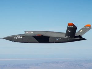
Figure 3.19 Kratos-built XQ-58 Valkyrie Drone
Source: (Lye, 2019)
Boeing Loyal Wingman Drone
Finally, we end this chapter with the Boeing Loyal Wingman Drone. The Royal Australian Air Force has its first Boeing-built drone-jet hybrid prototype, which will use artificial intelligence to conduct intelligence, surveillance, and reconnaissance missions to supply fighter pilots with more information during a conflict.
The company delivered its first “loyal wingman” prototype to Australia this week (7 May 2020); it is expected to be used in tandem with fourth- and fifth-generation fighters on the battlefield, officials said in a release. See Figure 3.20. (Pawlyk, 2020)
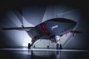
Figure 3.20 Boeing Loyal Wingman Drone
Source: (Pawlyk, 2020)
It is also the first aircraft “to be designed, engineered and manufactured in Australia in more than 50 years,” Boeing said, adding that it is the company’s “largest investment in an unmanned aircraft outside of the United States.” (Pawlyk, 2020)
The aircraft, which Boeing is co-developing with the government of Australia, was unveiled at the Avalon Airshow last year. Australia is investing roughly $40 million into the program, CNN reported. The jet is 38 feet long and can fly more than 2,000 nautical miles, according to its fact sheet. (Pawlyk, 2020)
It uses artificial intelligence “to fly independently or in support of manned aircraft while maintaining safe distance between other aircraft, the fact sheet states. The first prototype was constructed using digital engineering concepts, allowing developers to simulate parts via computer models, according to the company.
The concept is similar to an ongoing U.S. military effort. The U.S. Air Force has been working to develop its own “Loyal Wingman” program, featuring unmanned fighters that could think autonomously sent out alongside F-35 Joint Strike Fighters, for example, to scout enemy territory ahead of a strike, or to gather intel for the aircraft formation. In January 2020, the Air Force conducted test flights of the XQ-58A Valkyrie drone at Yuma Proving Ground, Arizona, taking the unmanned aerial vehicle, made by Kratos Defense, to higher altitudes than previous tests. (Pawlyk, 2020)
Conclusions
We end our tour de force having traveled through a palate of air and sea stories which should indicate to the student the diversity, complexity, technological growth, and ubiquitous nature of the unmanned industry. Definitely tip of the spear. No homework or discussion questions. Build your own library of information “Bullets” on UAS , UUV and UGT systems.
REFERENCES
Ball, M. (2020, July 20). Autonomous Underwater Glider Circumnavigates Atlantic Ocean. Retrieved from www.unmannedsystemstechnology.com: https://www.unmannedsystemstechnology.com/2020/07/autonomous-underwater-glider-circumnavigates-atlantic-ocean/
Ball, M. (2020, July 21). New Autonomous Guard USV Unveiled. Retrieved from www.unmannedsystemstechnology.com: https://www.unmannedsystemstechnology.com/2020/07/new-autonomous-guard-usv-unveiled/
Bombing, C. -C. (2020, August 4). Recognize Suspicious Unmanned Aircraft Systems (UAS). Retrieved from www.CISA.gov/obp: www.cisa.gov/usa-critical-infrastructure
Cole, S. (2020, August 3). Motherboard Tech: Cops are using drones to make sure people aren’t nude. Retrieved from https://www.vice.com/en_us/article/z3eqv5/minnesota-drone-nude-beach: https://www.vice.com/en_us/article/z3eqv5/minnesota-drone-nude-beach
Goward, D. (2020, July 20). GPS interference crashed a survey drone in the UK. Will the debate resonate in the US? OPINION. Retrieved from www.c4isrnet.com/opinion/: https://www.c4isrnet.com/opinion/2020/07/20/gps-interference-crashed-a-survey-drone-in-the-uk-will-the-debate-resonate-in-the-us/#:~:text=An%20expensive%20drone%20crashed%20into,site%20when%20the%20mishap%20occurred.
Greenwood, M. (2019, Jan 19). Could Drones Be Used to Deliver Transplant Organs? Retrieved from www.engineering.com/: https://www.engineering.com/DesignerEdge/DesignerEdgeArticles/ArticleID/18325/Could-Drones-Be-Used-to-Deliver-Transplant-Organs.aspx
Kesteloo, H. (2020, July 2). National Geographic team survey Everest with a drone at 28,300 feet. Retrieved from https://dronexl.co/2020/07/02/national-geographic-mount-everest-drone/: https://dronexl.co/2020/07/02/national-geographic-mount-everest-drone/
McNabb, M. (2019, March 3). Pay Attention to This One: Can You Be Sued for Flying a Drone Over Private Property? The Next Draft of that Tort Law. Retrieved from dronelife.com: https://dronelife.com/2019/03/19/can-you-be-sued-for-flying-a-drone-over-private-property-the-next-draft-of-that-tort-law/
Nichols, R. K. (2008, September 05). Counterintelligence & Sensitive Compartmented Information Facility . (SCIF) Needs – Talking Points.
Nichols, R. K. (2019, March 14). Hardening US Unmanned Systems Against Enemy Counter Measures. 7th Annual Unmanned Systems Summit. Alexandria, VA, USA: PPTX presentation , self.
Nichols, R. K., Mumm, H. C., Lonstein, W. D., Ryan, J. J., Carter, C. M., & & Hood, J. P. (2020). Counter Unmanned Aircraft Systems Technologies & Operations. Manhattan, KS: New Prairie Press #31.
Nichols, R. K., Mumm, H. C., Lonstein, W. D., Ryan, J. J., Carter, C., & and Hood, J.-P. (2019). Unmanned Aircraft Systems in the Cyber Domain, 2nd Edition. Manhattan, KS: NPP eBooks. 27. Retrieved from www.newprairiepress.org/ebooks/27
Nichols, R. (Nov 28-30, 2006). Cyber Terrorism, Critical Infrastructure, & SCADA Presentation. In R. Nichols (Ed.), Defense Threat Reduction Agency Conference. Shirlington VA: Utica College, Utica NY.
Nichols, R., Ryan, J., Mumm, H., Carter, C., Lonstein, W., & Hood, &. J. (2020). Counter Unmanned Aircraft Systems Technologies and Operations. Manhattan, KS: New Prairie Press #31.
Nichols, R., Ryan, J., Mumm, H., Lonstein, W., Carter, C., & & Hood, J. (2019). Unmanned Aircraft Systems (UAS) in Cyber Domain: Protecting USA’s Advanced Air Assets, 2nd Edition. Manhattan, KS: New Prairie Press #27 .
Nichols, R.-0. (2016, March 29). NCIE UAS SAA Final Rev 4. 2016 INFOWARCON conference presentation April 4-7, Nichols, R.K. et. al. (3-29-2016) Presentation to INFOWARCON April 4-7 on NCIE UAS SAA Final Rev 4, presented to 2016 INFOWARCON conference, Memphis TN. Available as PPTx presentation download from author or in CANVAS. Memphis, TN, USA: INFOWARCON16.
Ohnsman, A. (2020, July 1). Robot Trucks To Roam 1,100-Mile Phoenix-Houston Corridor Set Up By TuSimple, UPS, U.S. Xpress. Retrieved from www.forbes.com: https://www.forbes.com/sites/alanohnsman/2020/07/01/robot-trucks-to-roam-1100-mile-phoenix-houston-corridor-set-up-by-tusimple-ups-us-xpress/?ss=logistics-transport#24e1a00e3a84
O’Rourke, R. (2020, June 24). Navy Large Unmanned Surface and Undersea. Retrieved from fas.org/sgp/crs/weapons/: https://fas.org/sgp/crs/weapons/R45757.pdf
Osborn, K. (2019, October 15). Swarm Hell: Can the U.S. Army Stop Hundreds of Drones Armed with Explosives? Retrieved from National Interest: https://nationalinterest.org/blog/buzz/swarm-hell-can-us-army-stop-hundreds-drones-armed-explosives-88206
PRBC. (2020, August 6). PB2-21. – Proper attire required. Retrieved from minneapolisn.gov: https://library.municode.com/mn/minneapolis/codes/code_of_ordinances?nodeId=PAREBOCOOR_CH2GEREGOCO
Precision AG . (2020, June 11). precisionagreviews.com. Retrieved from www.precisionagreviews.com/: https://www.precisionagreviews.com/post/is-swarm-farming-the-future-of-farming
Randall K. Nichols, D. J. (2000). Defending Your Digital Assets against Hackers, Crackers, Spies and Thieves. New York: RSA Press.
Schadlow, B., & Helwig, N. (2020, July 1). Protecting undersea cables must be made a national security priority. Retrieved from www.defensenews.com/opinion: https://www.defensenews.com/opinion/commentary/2020/07/01/protecting-undersea-cables-must-be-made-a-national-security-priority/
Steffen, A. (2020, March 8). watch-the-world’s-first-manned-aerobatic-drone-loop-and-roll. Retrieved from https://www.intelligentliving.co: https://www.intelligentliving.co/watch-the-worlds-first-manned-aerobatic-drone-loop-and-roll/
USA weekly. (2020, June 17). Drone Technology Helps Researchers Count Turtles On The Great Barrier Reef. Retrieved from https://uasweekly.com/: https://uasweekly.com/2020/06/17/drone-technology-helps-researchers-count-turtles-on-the-great-barrier-reef/
UST Weekly eBrief. (2020, August 4th). HAPS UAV Completes Basic Flight Tests. Retrieved from www.unmannedsystemstechnology.com: https://www.unmannedsystemstechnology.com/2020/07/haps-uav-completes-basic-flight-tests/
Zimmer, J. (2020, June 12). Fighting COVID-19 with Disinfecting Drones and Thermal Sensors. Retrieved from new.engineering.com: https://new.engineering.com/story/fighting-covid-19-with-disinfecting-drones-and-thermal-sensors
[1] The full citation is : PB2-21. – Proper attire required.
No person ten (10) years of age or older shall intentionally expose his or her own genitals, pubic area, buttocks or female breast below the top of the areola, with less than a fully opaque covering in or upon any park or parkway, as defined in PB1-1. This provision does not apply to theatrical, musical, or other artistic performances upon any park or parkway where no alcoholic beverages are sold. (Code 1960, As Amend., § 1010.321; Pk. Bd. Ord. No. 82-102, § 1, 4-21-82)
[2] Lost on Everest Video trailer: https://youtu.be/fyE39a8f2Ao
[3] The full Dunstan et.al research paper for the Raine Island Turtle count entitled: “Use of unmanned aerial vehicles (UAVs) for mark-resight nesting population estimation of adult female green sea turtles at Raine Island” is found at: https://journals.plos.org/plosone/article?id=10.1371/journal.pone.0228524
[4] Equipment Involved in the Study : The drones used in the study include the MFD 5000 from Watts Innovation, the Agras MG-1 from DJI, and M6A PRO G200 with a 16-liter tank from Homeland Surveillance & Electronics. North Dakota State University is lending SkySkopes the M6A PRO G200. “Each drone has its unique advantages. The MFD 5000 is extremely customizable. The MG-1 is water-resistant and a “tried and true” (tool) for precise agricultural spraying,” said Dunlevy. For example, the M6A PRO G200 is designed specifically for crop dusting and spraying. (Zimmer, 2020)
[5] Maryland Test Confirms Drones Can Safely Deliver Human Organs- A kidney was flown thousands of meters by a drone without incurring any damage at: https://spectrum.ieee.org/the-human-os/robotics/drones/test-run-confirms-that-drones-can-safely-deliver-organs-for-transplant
[6] Author opinion.
[7] Note the Chinese influence here.
[8] Author emphasis
[9] Author emphasis
[10] Author emphasis
[11] Nadia Schadlow is a senior fellow at the Hudson Institute. She previously served as the U.S. deputy national security adviser for strategy. Brayden Helwig is a national security and international affairs summer intern.
