2 Useful Applications for Site Assessment
Introduction
There are many applications (apps) that are useful for site assessment. A selection of these apps are summarized below in alphabetical order, along with links to where those apps can be accessed or downloaded.
Google Earth
Google Earth (Google 2023) is a free mapping app from Google (Alphabet Inc., Mountain View, California, US) that encompasses several apps available on multiple platforms, including a web app accessible through an internet browser, Android and iPhone apps, and a desktop App called Google Earth Pro. Google Earth is novel in that it superimposes satellite imagery on a three-dimensional globe. Features that are particularly useful for site evaluation include the ability to change the satellite imagery to previous dates, which allows users to see potential land use changes or changes due to stream or gully erosion. Users can also drop pins to save locations, as well as use a measuring tool to estimate distances between two points.
LandPKS
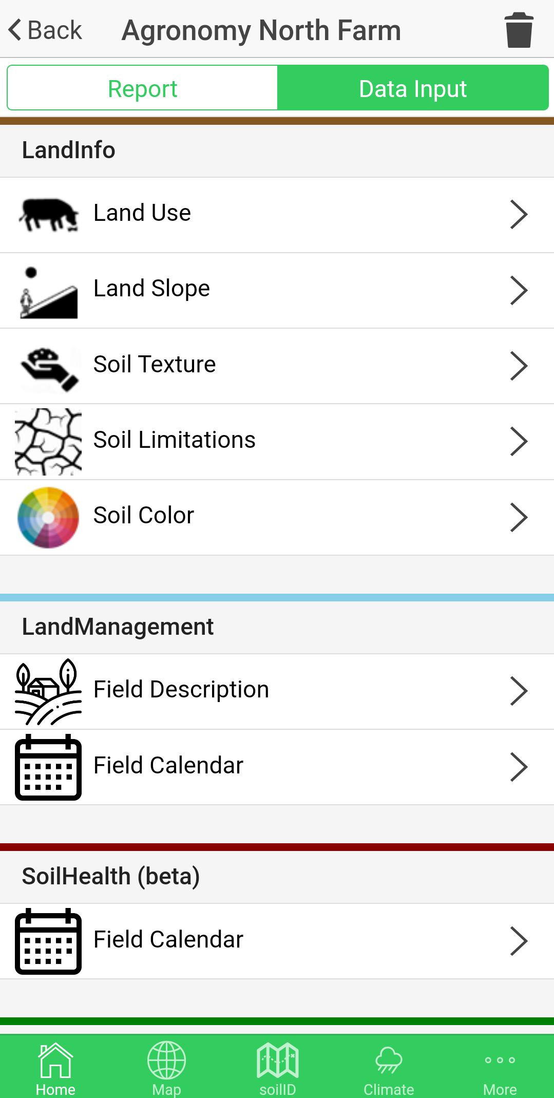
LandPKS (LandPKS 2024b), which is short for “Land Potential Knowledge System”, is a free mobile app developed by researchers at the Jornada Experimental Range. The developers state on the LandPKS website that the app features are to identify soil and land types, monitor soil health, monitor vegetation, and track land management. Within the US the LandPKS app heavily leverages Soil Survey Geographic Database (SSURGO) (USDA-NRCS Soil Survey Staff. n.d.) data to assist with identifying soil and land types. A notable feature is a slope meter that uses accelerometers in mobile devices to determine hillslope based on how much a phone is titled when it is visually aligned with a hillslope. The data input portion of the app includes detailed and easy-to-follow directions on how to determine slope, soil texture, soil limitations, soil color, and more. Several calendars are available to track land management practices and soil health data over time. The soil health assessment within the app corresponds to the Cropland In-Field Soil Health Assessment from the US Department of Agriculture Natural Resources Conservation Service (USDA-NRCS), which is used heavily in this laboratory manual. There is also a data portal (LandPKS 2024a) available through the LandPKS website to allow access to data through a computer.
Note: The LandPKS app is currently undergoing a redesign. It is a somewhat unstable app at the moment, and may necessitate being force-closed occasionally. Version 3 of the app is expected soon.
Breakout boxes such as the one below will be included in laboratory activities where data we are collecting directly corresponds to a feature in LandPKS.
LandPKS – Knowledge for Sustainable Land Management In Your Hands
Breakout boxes will include embedded videos and other useful tips for executing the specific task. Watch the video below for further introduction to the LandPKS app.
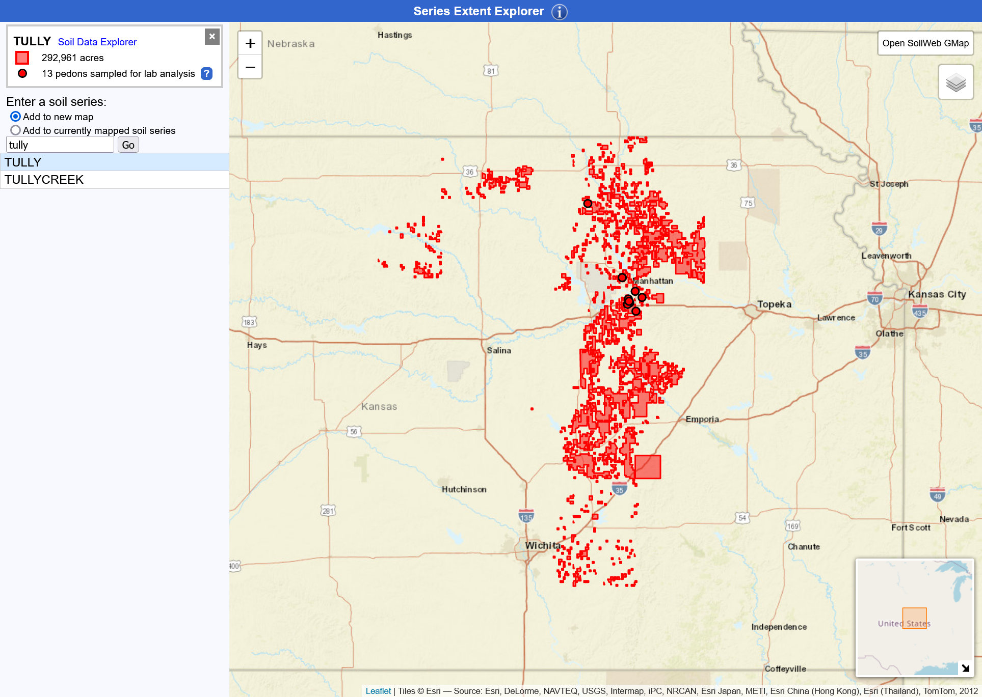
Series Extent Explorer
Series Extent Explorer (California Soil Resource Lab 2018a) is a web app that provides a map displaying the approximate geographic distribution of a specified soil series. The app was developed by the California Soil Resource Lab at University of California-Davis University of California Agriculture and Natural Resources in collaboration with the USDA-NRCS.
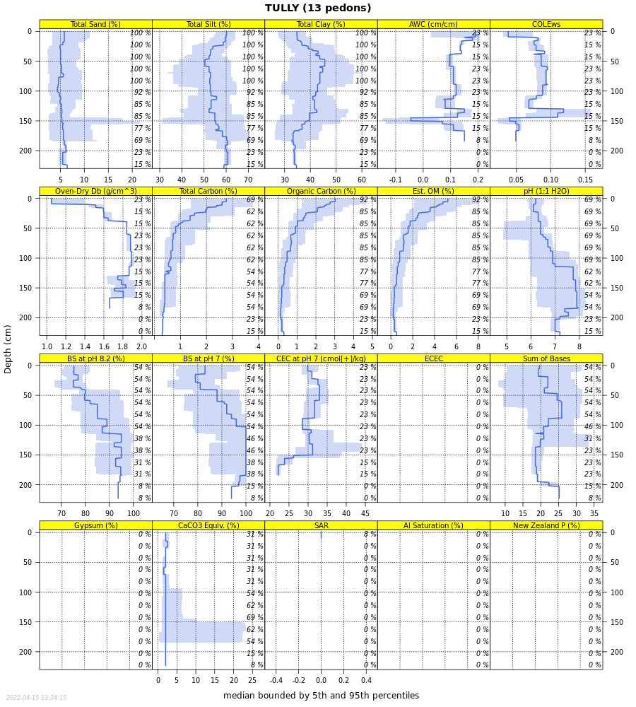
Soil Data Explorer
Soil Data Explorer (California Soil Resource Lab 2018b) is a web app that provides detailed information about soil series. Once a soil series name is entered it opens up a web page that displays the official series description. Other available tabs and information include Lab Data, Water Balance, Sibling Summary, Competing Series, Shared Subgroup, Block Diagrams, Map Units, and Extent. The app was developed by the California Soil Resource Lab at University of California-Davis University of California Agriculture and Natural Resources in collaboration with the USDA-NRCS.
Soil Explorer
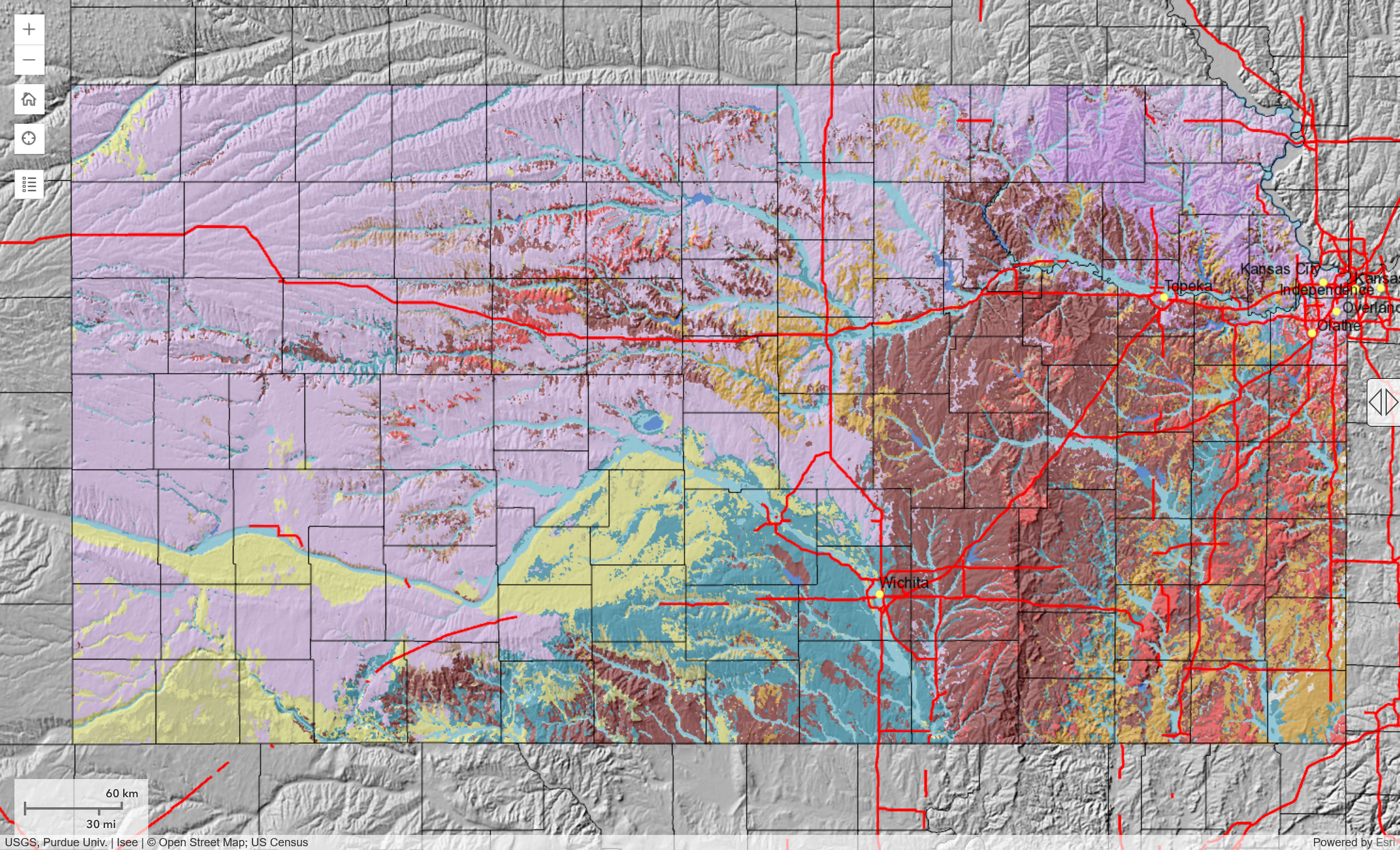
Soil Explorer (Isee Network. 2015, 2023) is available as a web app or Android and iPhone mobile apps that was developed by the Integrating Spatial Educational Experiences (ISEE) Network. The app is designed to demonstrate soil taxonomy and soil properties using maps. Users must select a region, as different data sets are available for different regions.
SoilWeb
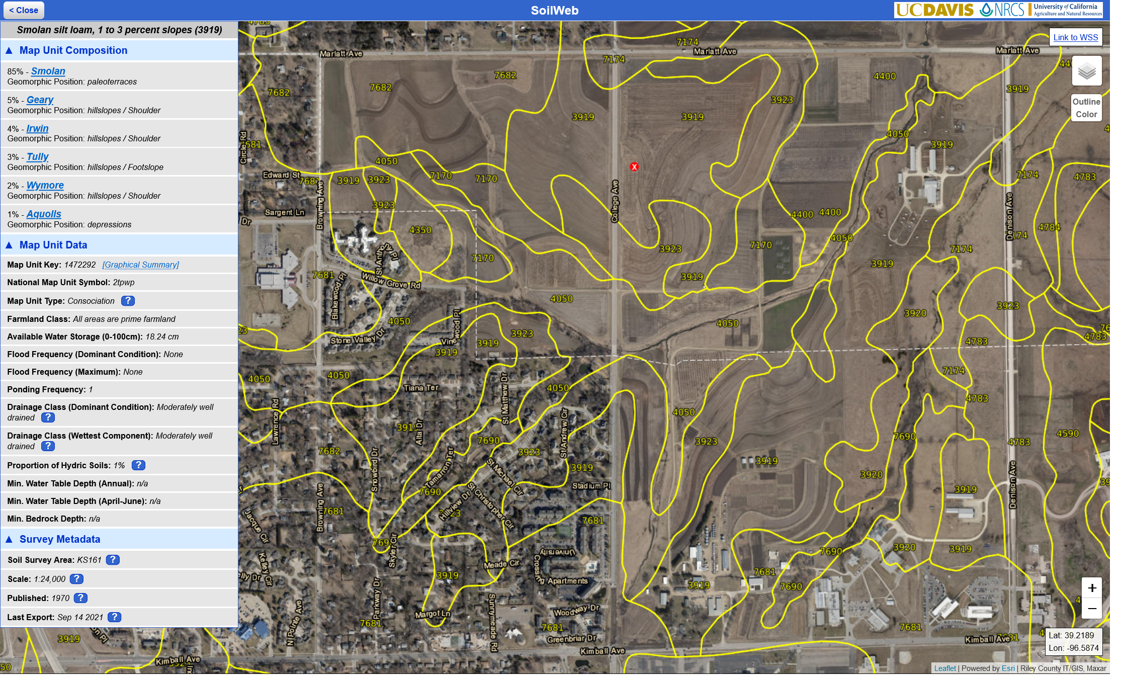
SoilWeb (California Soil Resource Lab 2018c) is a web app that allows users to explore National Cooperative Soil Survey (NCSS) data for locations in much of the US. Within the app users can navigate to a location and view mapping unit boundaries projected over current satellite imagery. Once a point location is selected the app displays the mapping unit composition, and allows users to explore the data associated with each of the soil series included within that map unit composition. Map unit data is also presented, which includes the map unit symbol, map unit type, farmland class, available water storage to a depth of 100 cm, flooding data, drainage class, and more. The SoilWeb web app is reliably available, while the Android and iPhone apps are available based on the availability of funding. The app was developed by the California Soil Resource Lab at UC Davis and UC-ANR in collaboration with the USDA-NRCS.
SoilWeb Earth
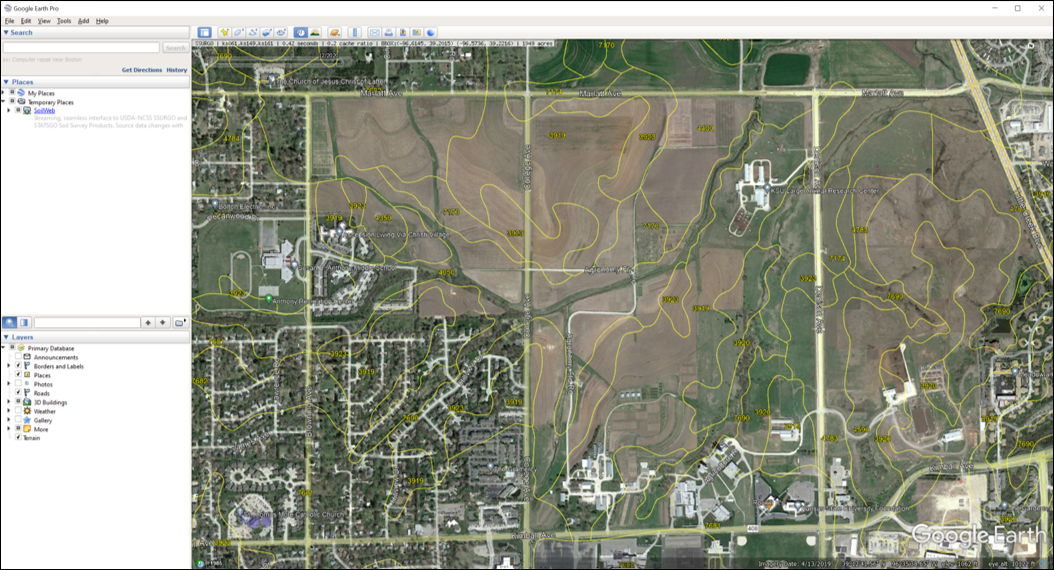
SoilWeb Earth (California Soil Resource Lab 2018d) allows soil data to be displayed within Google Earth in a KML file with interactivity and function similar to SoilWeb accessed through a browser. The SoilWeb Earth KML file was developed by the California Soil Resource Lab at University of California-Davis University of California Agriculture and Natural Resources in collaboration with the USDA-NRCS.
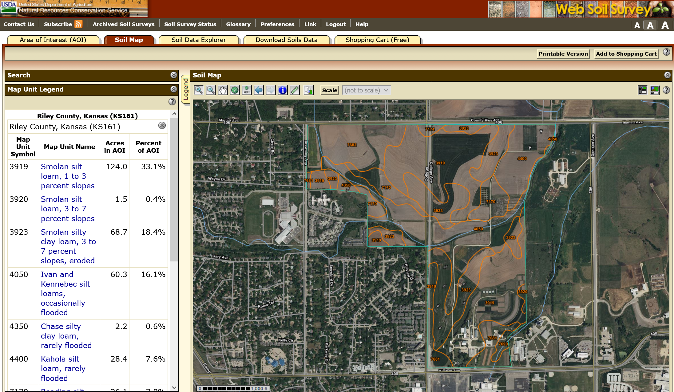
Web Soil Survey
Web Soil Survey (USDA-NRCS 2019) is a web app from the USDA-NRCS that provides soil data and information in SSURGO (USDA-NRCS Soil Survey Staff. n.d.) from the NCSS. Once an area of interest (AOI) has been designated, users can explore the Soil Map and then use the Soil Data Explorer to explore Suitability and Limitations for Use, Soil Properties and Qualities, Ecological Sites, and more. Soils data for the AOI can be downloaded, or a PDF report can be generated for download.