4 Soil Health Assessment Part II: Infiltration, Surface Crusts, Soil Structure, and Water Stable Aggregates
Infiltration, Surface Crusts, Soil Structure, and Water Stable Aggregates
Acknowledgement and Recommended Reading
This laboratory was designed to conduct in-field assessments of soil health and is based on the Cropland In-Field Soil Health Assessment Guide from the USDA-NRCS (2021). Additional information is available in USDA-NRCS Soil Quality Indicator Sheets from the USDA-NRCS for infiltration, slaking and soil crusts, and structure (2008a, 2008b, 2008c, 2008d) and the Field Guide for Describing and Sampling Soils (Shoeneberger et al. 2012). Methods and videos for the LandPKS app are provided for each activity. More information is available at the LandPKS website (2023).
Learning Objectives
By the end of the laboratory you will:
- Conduct a field assessment to characterize the infiltration rate, soil crusts, soil structure, and water stable aggregates
- Be prepared to determine need for conservation practices to address resource concerns associated with these soil health indicators
Materials
Materials required to complete this laboratory activity include the following:
- Thin-walled cylinder approximately 15 cm in diameter and 15 cm tall (6 in x 6 in)
- Block of wood and a mallet
- Water container approximately 4 L in volume (1 gal) filled with water
- Permanent marker or brightly colored tape
- Ruler or tape measure
- Stop watch or smart phone stop watch app
- Colander or wire mesh for suspending soil peds and aggregates in water
- Bowl or tall cylinder
- Water to fill the bowl or cylinder
Introduction
Soil physical properties can be used to assess soil health and to prescribe conservation practices that can improve soil function over time. In this lab you will learn how measure infiltration rate, observe the presence of surface crusts, evaluate soil color of the topsoil, and determine the type of soil structure in the topsoil.
Observing Ponding or Measuring Infiltration Rate
Standing water can be an indicator of poor infiltration, which may be caused by soil properties impacted by soil management including compaction, poor soil structure, poor aggregate stability, lack of ground cover, or soil crusting; or by natural soil conditions such as clayey soils, fragipans, duripans, and more. Surface ponding and prolonged saturation can cause runoff and erosion, damage to crops, problems with nutrient cycling, production of greenhouse gases and more.
The presence of ponded conditions can be observed directly within 24 hours of a typical rainfall or irrigation event. Determine if the ponded condition occurs throughout the field, or only in select locations.
Alternatively, conduct an infiltration test. Refer to the Soil Quality Test Kit Guide (SQTKG) for instructions on how to conduct this test. Select a location for the test that avoids areas likely to be compacted (headlands/turning rows, traffic lanes, and wheel tracks). Most soils should infiltrate within 30 minutes.
Assessing Ponding or Infiltration with LandPKS
Watch the video below for an overview of assessing ponding or infiltration and recording data in the LandPKS app.
Identifying Surface Crusts
Soils that are poorly aggregated are prone to surface crusting, especially when left uncovered and exposed to rainfall. Crusting can also occur in soils with salinity (high salt content) and/or sodicity (high sodium content) problems. Crusts limit aeration, infiltration, and seedling emergence causing problems for plant health, soil organisms, and nutrient management.
Assess the site for the presence of soil crusts by examining the field for crusts. Crusts will remain intact when picked up. This is best done after irrigation or rain. Recent full-width tillage may temporarily eliminate soil crusts. Further investigation may be warranted if saline, sodic, or saline-sodic conditions are expected or observed.
Assessing Surface Crusts with LandPKS
Watch the video below for an overview of assessing surface crusts and recording your observations using the LandPKS app.
Describing Soil Structure
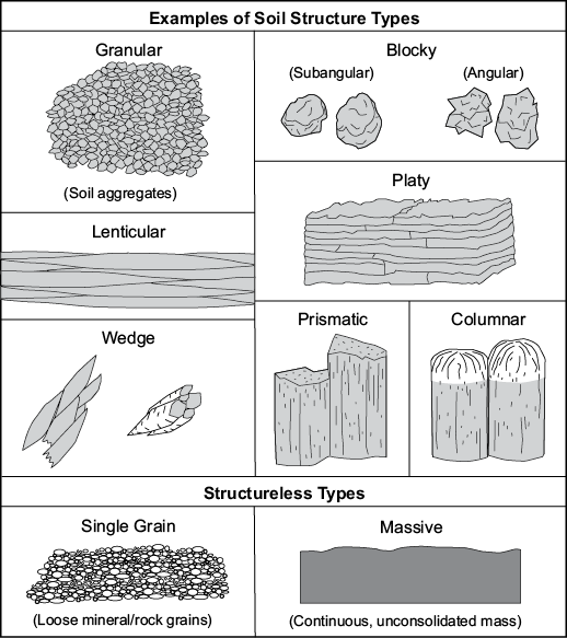
Soil structure impacts many biological, chemical, and physical soil properties. Soil structure can be negatively impacted by loss of soil organic matter, compaction, and soil management practices such as crop rotation, residue removal, tillage, and more.
Assess the soil structure by looking for the presence of granular structure, platy structure, or structureless massive conditions (Figure 4.1) within the top 30 cm of soil profile. This assessment can be conducted at any time, but may be impacted by recent full-width tillage operations. Comparison to the OSD, which can be accessed as described above, provides context for the potential of the soil.
Assessing Soil Structure with LandPKS
Watch the video below for an overview of how to record the soil structure in the LandPKS app.
Water Stable Aggregates
Soil properties and functions such as water infiltration, water storage, nutrient cycling, root growth, plant health, soil organism habitat, protection of soil organic matter, and more are all dependent on the stability of soil aggregates in water. Two methods of assessing water stable aggregates are presented here.
Cylinder Method
Collect a soil ped from the site just below any surface residue. The ped should be approximately the size of a golf ball. Allow the ped to air dry. Place the ped in a strainer basket and submerge it in a container. Observe the water after the ped has been submerged for 5 minutes. Is the clear or cloudy? Cloudiness caused by the soil slaking apart is caused by internal pressure or air inside the ped that is being forced out by water. The roots, root hairs, polysaccharides, and other “glues” that promote aggregation will help stable aggregates from breaking apart under this strain, while a lack of those “glues” will allow the ped to slake apart. Record your observations in the data sheet.
Strainer Method
Collect a sample of soil and break apart any large peds until aggregates are the the size of a BB or slightly larger. Place the soil in a stainer or fine mesh colander. Immerse the the colander in a water-filled bowl and allow the aggregates to saturate for approximately 1 minute. Dump the aggregates onto a flat surface and observe the stability of the aggregates. Water stable aggregates will maintain structure, while aggregates with poor aggregates will break apart and appear similar to pudding. This method does not require the aggregates to be air dry, and can be performed at various soil moisture contents.
Soil Quality Test Kit Guide Method
If you have access to the USDA-NRCS Soil Quality Test Kit and Guide you can use the method presented in Chapter 9 of that guide. The USDA-NRCS states this is the easiest method to perform in the field.
Assessing Aggregate Stability with LandPKS
Watch the video below for an overview of the three methods above and how to record aggregate stability data in the LandPKS app.
Questions
The following questions directly relate to this lab activity and will be answered as part of the Site Evaluation and Soil Health Assessment Report.
- Did any of the soil health indicators above not meet the soil health assessment criteria? Explain why.
- Where there any recent operations or site conditions that may have influenced any of the soil health assessments? Explain how the assessments may have been impacted.
References
LandPKS. 2021a. SoilHealth Trainings 4: Surface Crusts (Surface Crusting). https://youtu.be/U6aOei0xaEg.
LandPKS. 2021b. SoilHealth Trainings 5: Ponding (Ponding/Infiltration). https://youtu.be/VzYlW385s5g.
LandPKS. 2021c. SoilHealth Trainings 7: Aggregate Stability (Water-Stable Aggregates). https://youtu.be/N_lIu3YEHSc.
LandPKS. 2021d. SoilHealth Trainings 8: Soil Structure. https://youtu.be/pHPZWTBXGZs.
LandPKS. 2023. LandPKS. https://landpotential.org/.
Schoeneberger, P. J., D. A. Wysocki, E. C. Benham, and Soil Survey Staff. 2012. Field Book for Describing and Sampling Soils, Version 3.0. Lincoln, NE: USDA-NRCS. https://www.nrcs.usda.gov/resources/guides-and-instructions/field-book-for-describing-and-sampling-soils.
USDA-NRCS. 2001. Soil Quality Test Kit Guide. USDA-NRCS Soil Quality Institute. https://www.nrcs.usda.gov/sites/default/files/2022-10/Soil%20Quality%20Test%20Kit%20Guide.pdf.
USDA-NRCS. 2008a, June. Soil Quality Indicators: Infiltration. USDA-NRCS. https://www.nrcs.usda.gov/sites/default/files/2022-10/Infiltration.pdf.
USDA-NRCS. 2008b, June. Soil Quality Indicators: Slaking. USDA-NRCS. https://www.nrcs.usda.gov/sites/default/files/2022-10/Slaking.pdf
USDA-NRCS. 2008c, June. Soil Quality Indicators: Soil Crusts. USDA-NRCS. https://www.nrcs.usda.gov/sites/default/files/2022-10/Soil%20Crusts.pdf.
USDA-NRCS. 2008d, June. Soil Quality Indicators: Soil Structure & Macropores. USDA-NRCS. https://www.nrcs.usda.gov/sites/default/files/2022-10/Soil%20Structure%20and%20Macropores.pdf.
USDA-NRCS. 2021. Cropland In-Field Soil Health Assessment Guide. USDA-NRCS. https://www.nrcs.usda.gov/wps/portal/nrcs/detailfull/national/soils/health/?cid=nrcs142p2_053869.
USDA-NRCS. 2022. Conservation Practices. https://www.nrcs.usda.gov/wps/portal/nrcs/detailfull/national/technical/cp/ncps/?cid=nrcs143_026849.
