8 Ecological Site Descriptions
Recommended Reading
Learning Objectives
By the end of the laboratory you will:
- Identify the Major Land Resource Area (MLRA) where your site is located
- Identify the Ecological Site Description (ESD) that best represents your site using ESD keys
- Identify the state of the ESD that best represents your site using a state-and-transition model (STM)
- Consider land management decisions given the context provided by an ESD
Materials
Materials required to complete this laboratory activity include the following:
- Computer and/or mobile device with internet access
- Printed ESD keys for the appropriate MLRA
- Equipment for describing soil morphology
- Shovel or spade
- Soil knife
- Tape measure
- Water bottle for soil texture by feel
- Munsell soil color chart or the LandPKS app for determining soil color
- Clinometer or the LandPKS app for determining slope
- 10% hydrochloric acid for identifying carbonates
- Field Book for Describing and Sampling Soils (Schoeneberger et al. 2012), or PDF
- Note: if you do not have equipment or experience to describe soil morphology you can instead use a soil profile description from your site or use an Official Series Description (OSD) of one of the dominant soils for a soil mapping unit from your site
Introduction
The Interagency Ecological Site Handbook for Rangelands (Caudle et al 2013) states that Ecological Site Descriptions (ESDs):
“… provide a consistent framework for stratifying and describing rangelands and their soil, vegetation, and abiotic features; thereby delineating units that share similar capabilities to respond to management activities or disturbance processes.”
These ESDs provide land managers important information and context for making land use decisions, determining the suitability of land for specific land uses, evaluating how the land will respond to significant disturbances, and developing plans to facilitate long-term productivity. ESDs include site characteristics, plant communities, site interpretations, and supporting information.
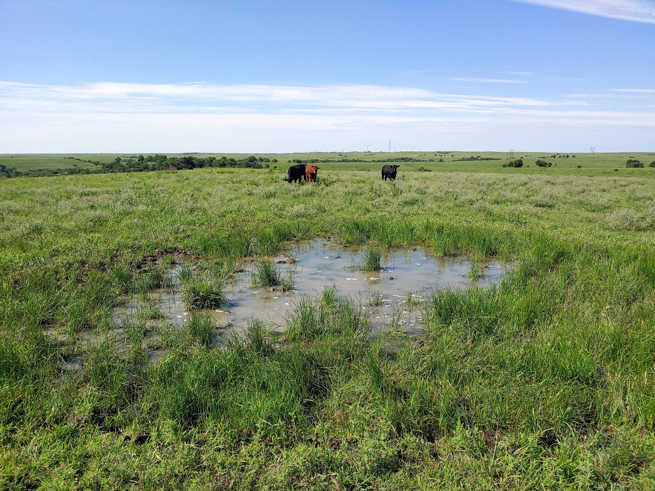
There are two types of ecological sites – forestland and rangeland. Forestland site types have and overstory canopy of at least 25% or more, while trees are not significant in rangeland reference plant communities. Reference plant communities are the plant community that was present at the time of the arrival of European immigrants to the location of interest. These plant communities are assumed to be best adapted to the soils, climate, and other environmental factors that influence the local area, and thus be the most resilient when exposed to natural disturbances such as fire, grazing, drought, and native fauna.
The reference plant community can be shifted towards other plant communities and conditions, which are referred to as “states”. The changes between states are termed “transitions”. A state-and-transition model (STM) is used to characterizes the known states and transitions for a specific ESD, and can be used as a framework for making management decisions.
Identify the MLRA
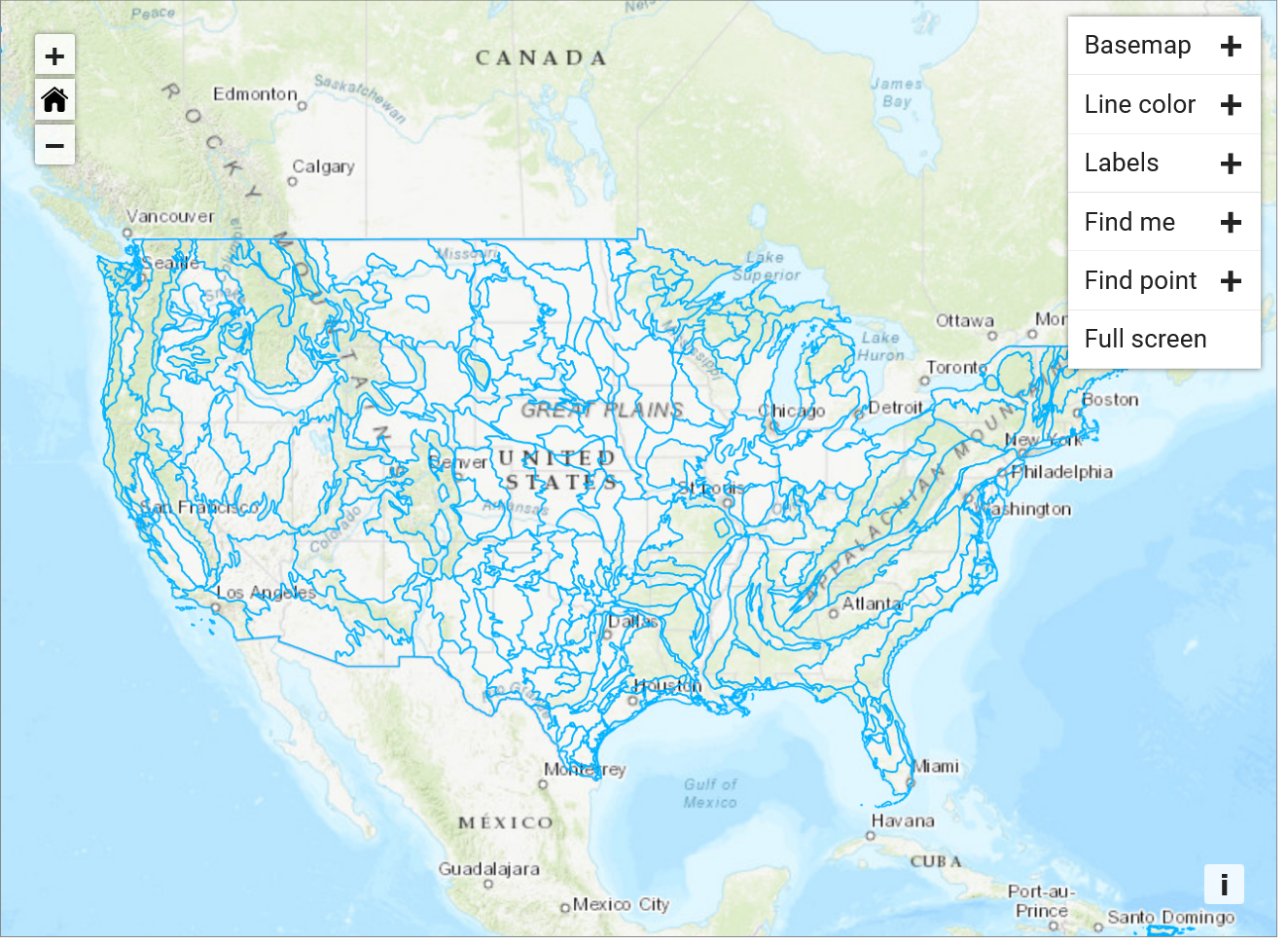
Ecological Site Descriptions are developed within boundaries of MLRAs. If you do not know the MLRA on which your site is located you can use the interactive map on Ecosystems Dynamics Interpretative Tool (EDIT) ESD Catalog to determine the MLRA (USDA-ARS Jornada Experimental Range, USDA-NRCS, and New Mexico State University 2022). Using the MLRA interactive map in EDIT, click on the appropriate MLRA to determine the name and number of the MLRA, then click on the MLRA name. This will open a “Quick View” of the MLRA with some basic statistics. Using the side menu on the left side of the EDIT website, click on “MLRA List”. Scroll to find the appropriate MLRA, or use the search function. Click on MLRA name to open the web page for that MLRA. Make a note of the MLRA name and number, then move on to the next step.
Use Keys to Identify the ESD
Once the appropriate EDIT web page for the MLRA is open, click on the “Ecological Site Keys” menu item on the left-side menu. This will open a list of ecological site keys. Download the appropriate key, which will be a PDF (note, you will need a PDF viewing application on your device to read the keys). Use the keys to identify the most appropriate ESD for your site.
Ecological site keys will use soils data, slope and landform information, and indicator plant species to identify the most appropriate ESD for the site. Using the keys may require you to perform a soil profile description to characterize the soil depth, texture, structure, presence of carbonates or other salts, etc. You are encouraged to do this on your own. However, if you do not have experience in describing soil morphology you may differ to the official series description (OSD) of the dominant soil(s) for the mapping unit that has been described for the site. Note that some mapping units may include multiple components which may be associated with different ESDs. Use your best judgment when differing to OSDs and soil survey information.
Once you have identified the most appropriate ESD using the keys, access the appropriate ESD by navigating to the “Ecological Site List” using the side menu within EDIT. You can scroll to the appropriate ESD or use the search feature. Click on the appropriate ESD to open it. This will open a new web page for that specific ESD. The web page defaults to General Information, which provides a brief description of the MLRA and its associated ESDs. Note: there is an option to download the ESD in its entirety as a single PDF at the bottom of the MLRA Notes page. Review the physiographic, climatic, water, soil, and plant features to confirm you have selected the appropriate ESD using the keys. Download a copy of the ESD PDF and save it to your device. You will submit this as part of the laboratory report later.
Identify the Representative ESD State
The state-and-transition model of the ESD is located in the “Ecological Dynamics” section. Each state is represented by numbered squares (boxes) representing the states. Arrows going from one state to another indicate transitions between states. A concise summary of the transitions are listed immediately below the state-and-transition model.
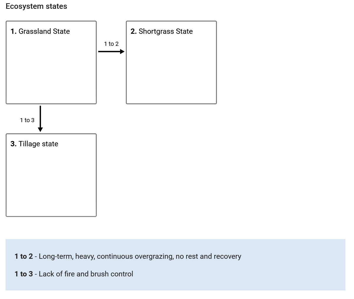
The state-and-transition model is followed by submodel diagrams indicating various plant communities that may be present within a given state. There can be one or several different plant communities present within each state. Transitions between each plant community may also be described.
As you scroll down the Ecological Dynamics section of the ESD you will find a detailed description of the states and plant communities. These include pictures of the reference state and plant communities as well as information and data about disturbances, resilience management, dominant plant species, and annual production by plant type (grass/grasslike, forb, shrub/vine).
Determine the state that best categorizes your site using the state-and-transition models, submodels, and associated information. Make a note of the state, then move on to the next step.
Confirming ESD Using Web Soil Survey or SoilWeb
The SSURGO database associates each soil mapping unit component (soil series) with specific ESDs. These can be viewed in both the Web Soil Survey and SoilWeb web apps. Using either Web Soil Survey or SoilWeb determine the ESD associated with the soil series present at your site and compare that ESD to what you identified previously using the ESD keys. Note that SoilWeb works well in a mobile device browser, and can be accessed from the field when cellular signal is available.
ESDs in Web Soil Survey
Open Web Soil Survey in your internet browser, then navigate to the location of your site. Define your Area of Interest (AOI), then switch to the “Soil Data Explorer” tab. Within the Soil Data Explorer navigate to the “Ecological Sites” tab and click on the “View All Ecological Site Info” button. This will load a map of the AOI with the ESD of the dominant mapping unit component displayed for each mapping unit. Scroll down to view the ESDs listed for each mapping unit component. Identify the mapping unit and mapping unit component of interest to determine the ESD for the site. You may need to explore information each of the mapping unit components (soil series) to confirm that it corresponds to what you observed at your site. Note the name of the ESD is a hyperlink to the ESD web page within EDIT. Make a note of the ESD name and compare that to what you identified using the ESD keys previously.
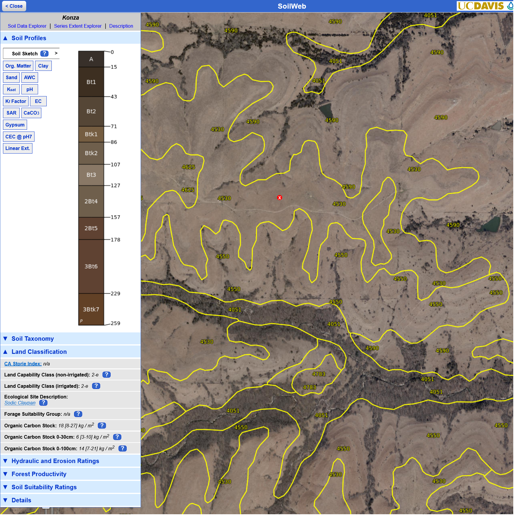
ESDs in SoilWeb
Open SoilWeb in your browser and navigate to your site. Click on the map at the location of interest. This will open a window on the left side of the screen which depicts the mapping unit components for that location. Explore the soil properties to confirm which soil series best correlates to what you observe at the site. Once the most relevant soil series is identified, click on the soil series name and expand the “Land Classification” tab. Note the name of the ESD listed under the “Ecological Site Description:” heading. The name of the ESD is a hyperlink to the ESD web page in EDIT. Make a note of the ESD name and compare that to what you identified using the ESD keys previously.
Using ESDs for Land Management Decisions
Ecological Site Descriptions are particularly useful as context for making land management decisions. For example, if the site is being used for range, the descriptions of transitions between states and/or plant communities can be helpful for making decisions about prescribed burning regimes, stocking, or invasive species management. Likewise, the ESD can contain useful information about species to use when seeding to restore farmland to prairie, or when allowing land to “go-back” to prairie without reseeding. From a row crop agriculture perspective ESDs can provide important context for what might be possible regarding improvements to soil health or carbon sequestration potential. Answer the questions below in order to gain a better understanding of how ESDs can be used for land management decisions.
Questions
The following questions directly relate to this lab activity and will be answered as part of the Site Evaluation and Soil Health Assessment Report.
- In what MLRA (name and number) is your site located?
- Describe the decisions you made using the ESD key to determine the most appropriate ESD for your site. Provide data or observations from your site that was used to make decisions as needed.
- Identify the representative ESD state that best represents your site. Describe how you came to that conclusion based on the state-and-transition model and supporting information in the “Ecosystem Dynamics” section of the ESD.
- How did the ESD you identified using the ESD keys compare to the ESD identified using Web Soil Survey or SoilWeb? It is alright if they differed. If they did differ, explain what may have caused a difference.
- Recall the responses to the interview questions from the land manager who oversees the site. What are their goals for the site, and how does that differ from the current ESD state?
- Based on the potential transitions described in the ESD, how could your site be managed differently to transition it to a different state? If the current state and the land managers desired state are different, how could the site be managed to achieve that transition?
- If you had access to locations that represent reference plant communities as well as other states and had permission to sample those locations, describe what you would do to determine the “potential” of your site for improvements to soil health or carbon sequestration. Also, describe the limitations of such comparisons.
- Save the PDF of the ESD you identified for your site for future submission as part of the Site Evaluation and Soil Health Assessment Report.
References
Caudle, D., H. Sanchez, J. DiBenedetto, C. Talbot, and M. Karl. 2013. The Interagency Ecological Site Handbook for Rangelands. 110. Washington, DC: The US Department of Agriculture’s Natural Resources Conservation Service and Forest Service, and the US Department of the Interior’s Bureau of Land Management. https://jornada.nmsu.edu/files/InteragencyEcolSiteHandbook.pdf.
Perez, J. 2022. Ecological Site Descriptions. https://archive.jornada.nmsu.edu/esd.
Schoeneberger, P. J., D. A. Wysocki, E. C. Benham, and Soil Survey Staff. 2012. Field Book for Describing and Sampling Soils, Version 3.0. Lincoln, NE: USDA-NRCS.
USDA-ARS Jornada Experimental Range, USDA-NRCS, and New Mexico State University. 2022. Ecological Site Descriptions. https://edit.jornada.nmsu.edu/catalogs/esd.
USDA-NRCS. 2019a. Ecological site HX076XY103 Sodic Claypan. MLRA 76X – Bluestem Hills: USDA-NRCS. https://edit.jornada.nmsu.edu/catalogs/esd/076X/HX076XY103.
USDA-NRCS. 2019b. Web Soil Survey. https://websoilsurvey.sc.egov.usda.gov/App/HomePage.htm.
USDA-NRCS. 2022a. Ecological Site Descriptions. https://www.nrcs.usda.gov/getting-assistance/technical-assistance/ecological-sciences/ecological-site-descriptions.
