2 Key Concepts in Soil Science
Colby Moorberg; Eric Brevik; and Kaizad Patel
Abbreviations
NCSS – National Cooperative Soil Survey
NRCS – Natural Resources Conservation Service
US – United States
USDA – US Department of Agriculture
Basic Concepts of Soil Science

Ecological Society of America. 1997. “Ecosystem Services: Benefits Supplied to Human Societies by Natural Ecosystems.” 2. Issues in Ecology. Washington, D.C.: Ecological Society of America. https://www.esa.org/esa/wp-content/uploads/2013/03/issue2.pdf.
Ecologists have long recognized and discussed ecosystem services, but soil science and other fields now recognize ecosystem services and widely discuss their importance. This article defines ecosystem services and describes the different types of services. The differences between services provided naturally contrast with technological services like engineering. Several examples of important ecosystem services are given, including those supplied by soils and those important to agriculture. Threats to ecosystem services and methods to assign a monetary value to them are also covered.
Ingham, Elaine R., Andrew R. Moldenke, and Clive A. Edwards. 2000. “Soil Biology Primer.” USDA NRCS. Soil and Water Conservation Society, Ankeny, IA. 2000. https://www.nrcs.usda.gov/resources/education-and-teaching-materials/soil-biology-primer.
Soil supports life, and a number of biological organisms (macro- and micro-organisms) are found in the soil. This USDA NRCS web page, also available in print, describes various biological groups found in soils and their role in maintaining soil fertility. The “food web” sections describe predator-prey and feeding interactions among organisms. The bacteria and fungi sections focus on microorganisms that decompose organic matter and help maintain nutrient levels in soils. Nematodes feed on microorganisms and arthropods chew and shred leaf matter that bacteria and fungi then decompose. Earthworms chew and decompose organic matter and mix the soil, among other functions.
McCauley, Ann, Clain Jones, and Jeff Jacobsen. 2005. “Module I – Basic Soil Properties 4481-1.” In Soil and Water Management, 12. 4481-1. Bozeman, MT: Montana State University. http://landresources.montana.edu/swm/.
In this chapter of a five-chapter self-study course at Montana State University, the authors discuss how soil physical properties like texture and structure influence water retention and chemical properties of the soil. Chemical properties include cation and anion exchange, pH and acidity, and salinity. How carbonates affect soil physical and chemical properties is also described. The chapter concludes by discussing how soil organic matter and soil organisms influence a wide range of basic soil properties.
Needelman, B. A. 2013. “What Are Soils.” Nature Education Knowledge 4 (3): 2. https://www.nature.com/scitable/knowledge/library/what-are-soils-67647639.
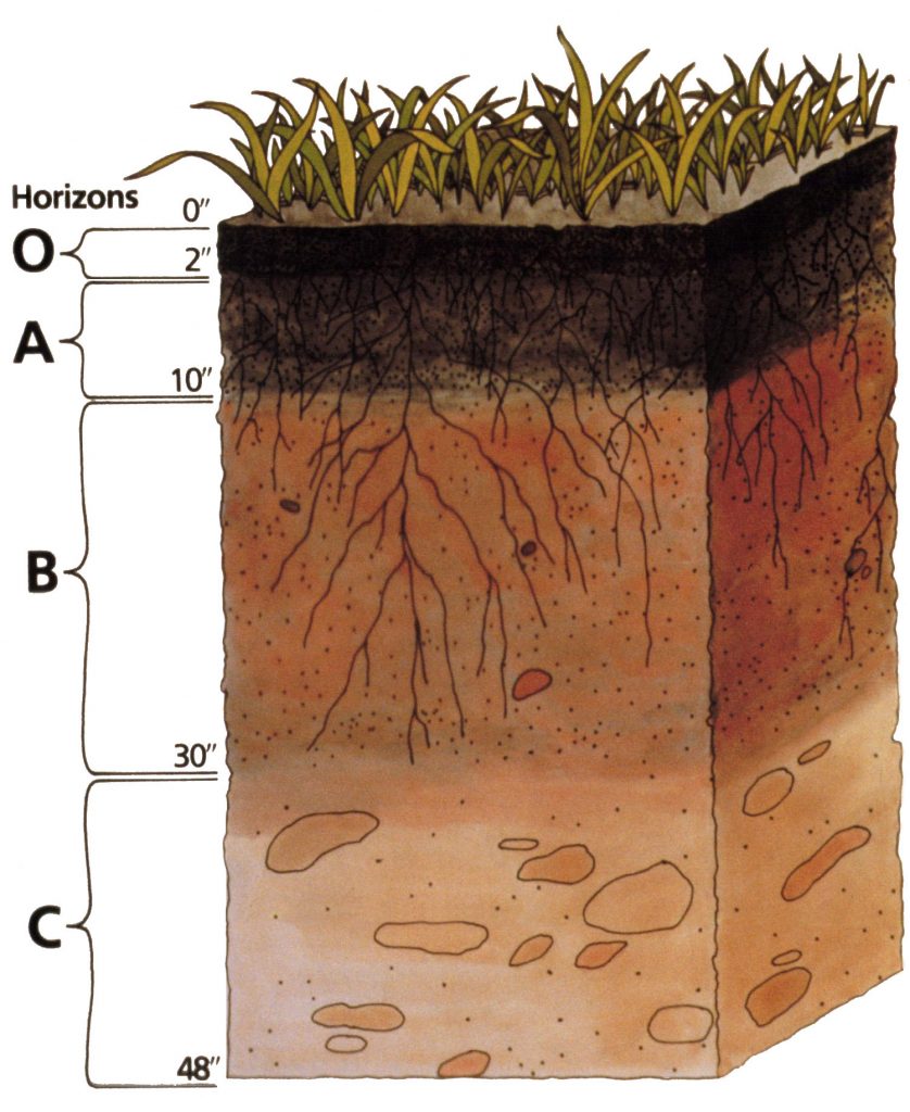
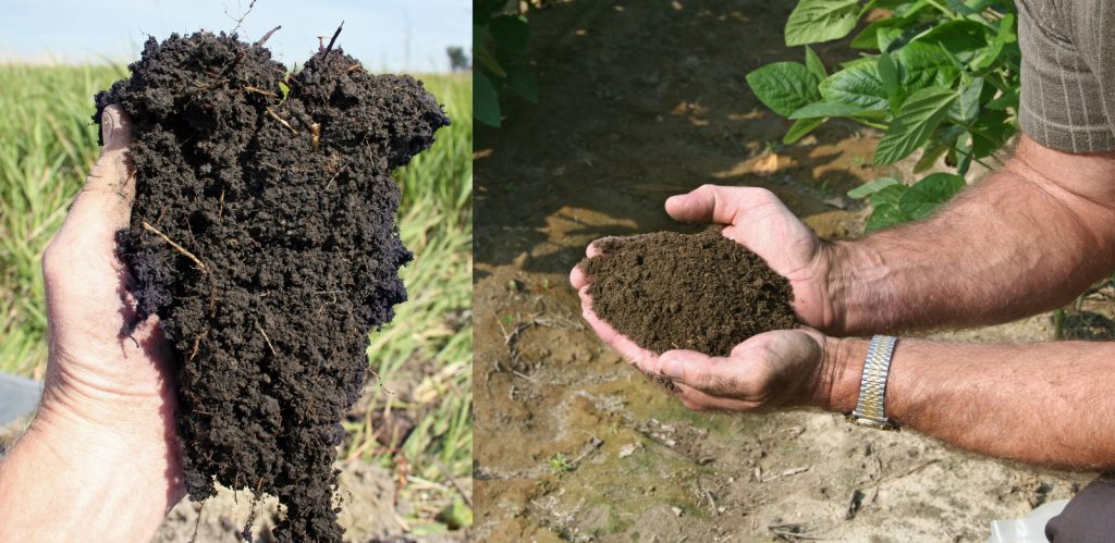
This article from the Nature Education Project introduces readers to the diversity of soils, particularly their composition, visual appearance, nutrient availability, and ecosystem services and benefits. Needleman describes soil composition using five ingredients: minerals, soil organic matter, living organisms, gas, and water. He also describes them as natural bodies that differ in visual appearance (colors, horizons, and layers), availability of plant nutrients, and ecosystem services and benefits.
O’Geen, A. T. 2012. “Soil Water Dynamics.” Nature Education Knowledge 3 (6): 12. https://www.nature.com/scitable/knowledge/library/soil-water-dynamics-103089121.
The sustainability of water quality and quantity is directly influenced by soil. Thus, most aspects of terrestrial and freshwater aquatic life depend on hydrologic processes in soil. This article from the Nature Education Knowledge Project focuses on soil water dynamics and introduces concepts of soil moisture storage, water flow, and the soil properties that influence these processes. O’Geen provides an introduction to the soil water balance equation, describes the factors and soil properties that govern water potential and plant available water holding capacity, and soil morphologic features and classification methods to describe the fate of water in soil.
Peterson, J. M. Ed. 2019. Soils – Part 2: Physical Properties of Soil and Soil Water. https://passel2.unl.edu/view/lesson/0cff7943f577.
This web page from the Plant and Soil Sciences eLibrary describes the physical composition of soil (solids, liquids, and gases) and basic physical properties. Those physical properties include soil texture and particle size, structure, particle density, bulk density, and porosity. The web page concludes by showing the context for these physical properties in soil profiles and soil classification.
Scheyer, J.M., and K.W. Hipple. 2005. Urban Soil Primer. Lincoln, NE: US Department of Agriculture Natural Resource Conservation Service. https://nrcspad.sc.egov.usda.gov/DistributionCenter/product.aspx?ProductID=479.
The Urban Soil Primer is intended to give planning officials and people who live in urban areas an introduction to soils. It provides information important for planning and managing land resources to help prevent or mitigate problems associated with sedimentation, contamination, runoff, and structural failure. This publication describes in nontechnical language the basic processes and functions common to all soils.
USDA NRCS. 2011. “Chapter 4 Elementary Soil Engineering.” In Engineering Field Handbook, 99. 210–VI–EFH. Washington, D.C.: USDA NRCS. https://directives.sc.egov.usda.gov/OpenNonWebContent.aspx?content=17543.wba.
The Soil Conservation Service (now USDA NRCS) provides technical assistance for using soil as a building material or as support for buildings and infrastructure. This chapter from the USDA NRCS Engineering Field Handbook outlines the fundamentals of soil engineering, which apply the physical, chemical, and mechanical properties of soil to their use as a construction material and as a foundation for structures. Fundamental soil engineering topics covered include the basic soil concepts that relate to engineering; an engineering classification and description system for soil; and guides for estimating soil strength, permeability, erosion resistance, and other performance characteristics. Site investigations and procedures for embankment design of earth dams are also discussed.
Soil Quality
“Chapter 3, Soil Water.” 2018. Plant and Soil Sciences ELibrary. 2018. http://croptechnology.unl.edu/pages/informationmodule.php?idinformationmodule=1130447123&topicorder=3&maxto=73&minto=1.
Soil water is important in crop production and the movement of nutrients and contaminants through the near-surface environment. This article provides a basic overview of soil water concepts and the fundamental soil properties that control soil water content and movement. This web page begins by defining types of soil water and the tensions at which the water is held in the soil. Available water holding capacity, infiltration, and water movement are then briefly described.
USDA NRCS. 1996a. “Soil Quality Indicators: Aggregate Stability.” Soil Quality Information Sheet. Lincoln, NE: US USDA. https://nrcspad.sc.egov.usda.gov/DistributionCenter/product.aspx?ProductID=386.
Soil quality is generally defined as the capacity of a soil to function for a specific purpose. Various indicators are used to assess soil quality. This USDA NRCS fact sheet summarizes one such indicator: aggregate stability. The information sheet also summarizes the relationship between soil quality and soil function, improving soil aggregate stability, and methods for assessing soil aggregates.
USDA NRCS. 1996b. “Soil Quality Indicators: Soil Crusts.” Soil Quality Information Sheet. Lincoln, NE: USDA. https://nrcspad.sc.egov.usda.gov/DistributionCenter/product.aspx?ProductID=387.
Soil quality is generally defined as the capacity of a soil to function for a specific purpose. This USDA NRCS fact sheet summarizes soil crusts as an adverse effect of declining soil quality. This document summarizes inherent and dynamic soil properties that influence soil crusting, the relationship to soil function, methods for avoiding soil crusting, and methods for measuring soil crusting.
USDA NRCS. 1996c. “Soil Quality Resource Concerns: Sediment Deposition.” Soil Quality Information Sheet. Lincoln, NE: USDA. https://nrcspad.sc.egov.usda.gov/DistributionCenter/product.aspx?ProductID=388.
In this soil quality information sheet, the USDA NRCS defines sediment as solid material that has been moved by air, water, gravity, or ice from its original location to a field or low landscape position. Sediment, when deposited on agricultural fields, can cause major problems for crop or forage production. The NRCS goes on to describe the effect of sediment deposition on soil quality, how to identify sediment, and what can be done about sediment.
USDA NRCS. 1998a. “Soil Quality Resource Concerns: Soil Erosion.” Soil Quality Information Sheet. Lincoln, NE: USDA. https://nrcspad.sc.egov.usda.gov/DistributionCenter/product.aspx?ProductID=391.
Erosion is one of the major threats to soil quality. This USDA NRCS information sheet describes why erosion is a problem, signs that indicate erosion, ways to quantify erosion, and conservation practices that can limit erosion. Both wind and water erosion are discussed.
USDA NRCS. 1998b. “Soil Quality Indicators: Infiltration.” Soil Quality Information Sheet. Lincoln, NE: USDA. https://nrcspad.sc.egov.usda.gov/DistributionCenter/product.aspx?ProductID=397.
Water can only be used by crops if it infiltrates the soil. Water that runs off the soil surface is not available to the soil environment or the plants growing in the soil. Therefore, infiltration is critical for water availability and overall soil function. In this information sheet, the USDA NRCS defines infiltration and describes the factors that affect infiltration rates, why low infiltration rates are generally not desirable, ways to improve infiltration, and a simple way to measure infiltration.
USDA NRCS. 1998c. “Soil Quality Indicators: Soil pH.” Soil Quality Information Sheet. Lincoln, NE: USDA. https://www.nrcs.usda.gov/sites/default/files/2022-10/soil_ph.pdf.
Soil pH is a soil master variable that influences nutrient availability, microbial communities, and many other soil properties. This USDA NRCS information sheet defines soil pH, explaining why it is important, what affects soil pH, a common and simple way to measure soil pH, and how to modify soil pH.
USDA NRCS. 1998d. “Soil Quality Resource Concerns: Soil Biodiversity.” Soil Quality Information Sheet. Lincoln, NE: USDA. https://nrcspad.sc.egov.usda.gov/DistributionCenter/product.aspx?ProductID=414.
In this USDA NRCS soil quality information sheet, the USDA NRCS defines soil biodiversity and describes the benefits of soil organisms as well as management techniques that promote soil biodiversity. It includes a diagram that simplifies soil biodiversity as a concept and groups soil organisms by trophic levels.
USDA NRCS. 1998e. “Soil Quality Resource Concerns: Salinization.” Soil Quality Information Sheet. Lincoln, NE: USDA. https://nrcspad.sc.egov.usda.gov/DistributionCenter/product.aspx?ProductID=392.
In this soil quality information sheet, the USDA NRCS defines salinization as the process by which salts accumulate in the soil. The USDA NRCS then describes the causes and indicators of salinization, the effects of salinity, and how salinity can be managed.
USDA NRCS. 2001a. Guidelines for Soil Quality Assessment in Conservation Planning. 48. Washington, D.C.: USDA. nrcs.usda.gov/sites/default/files/2023-04/nrcs142p2_050963.pdf.
In this guide for soil quality assessment in conservation planning, the USDA NRCS describes their conservation planning process, introduces the concepts of soil quality, and describes how to collect and analyze information to assess soil quality. The guide also includes a list of additional resources. This guide can be used as a planning guide for informal assessments or for quick assessment of soil quality.
USDA NRCS. 2001b. “Soil Health Assessment.” Washington, D.C.: USDA. https://www.nrcs.usda.gov/conservation-basics/natural-resource-concerns/soils/soil-health/soil-health-assessment.
The terms soil health and soil quality are often used synonymously, as on this USDA NRCS web page. On this page, the USDA NRCS describes the concept of soil health and provides links to downloads of soil quality indicator sheets. They state that measurements of soil quality are only useful if the indicators measure changes in soil function; encompass chemical, biological, and physical properties; are accessible to many users under applicable field conditions; and are sensitive to variations in management and climate. The relationship of soil quality indicators to soil health is briefly explained with examples. The web page then concludes by describing and linking to another document: “Guidelines for Soil Quality Assessment in Conservation Planning.”
USDA NRCS. 2001c. “Rangeland Soil Quality – Organic Matter.” Soil Quality Information Sheet 6. Rangeland Soil Quality. Lincoln, NE: US Department of Agriculture. https://nrcspad.sc.egov.usda.gov/DistributionCenter/product.aspx?ProductID=384.
In this soil quality information sheet, the USDA NRCS describes the importance of soil organic matter to rangeland soil quality. In the guide, the USDA NRCS defines soil organic matter, why it is so important to our soils, what affects organic matter, and how to maintain optimum soil organic matter content. While the focus of the information sheet is rangeland soils, the general principles apply to a wide range of land uses and soil management strategies.
USDA NRCS. 2003. “Managing Soil Organic Matter: The Key to Air and Water Quality.” Soil Quality Technical Note No. 5. USDA. https://nrcspad.sc.egov.usda.gov/DistributionCenter/product.aspx?ProductID=398.
This technical note from the USDA NRCS Soil Quality Institute focuses on managing soil organic matter. The note begins by explaining why erosion control alone is not enough to conserve soil and the rationale for focusing on soil organic matter. The Soil Quality Institute also describes why soils should be managed for carbon, not just keeping erosion at a tolerable annual rate. The note concludes with an overview of those soil properties influenced by soil organic matter and what soil managers can do to manage for carbon.

Soil Health
Al-Kaisi, Mahdi, and David Kwaw-Mensah. 2017. “Iowa Soil Health Management Manual.” Extension Publication CROP 3090A. Ames: Iowa State University Extension and Outreach. https://store.extension.iastate.edu/product/Iowa-Soil-Health-Management-Manual.
This Iowa State University extension publication centers on appropriate soil management and how that leads to sustainable agricultural systems. It begins by explaining the fundamentals of soil science essential for appropriate soil management and then defines soil health and explains why that is important. This is followed by chapters that cover management practices that build soil health and how to evaluate the health of a soil.
USDA NRCS. 2018a. “Healthy Soils Are Full of Life.” USDA. https://nrcspad.sc.egov.usda.gov/DistributionCenter/product.aspx?ProductID=1023.
The abundance of life present in a healthy soil is the focus of this USDA NRCS information sheet. It includes a brief discussion of what farmers can do to build a soil ecosystem with abundant and diverse organisms and explains the fundamental function of each major non-plant organismal group found in soil.
USDA NRCS. 2018b. “Healthy Soils Are High in Organic Matter.” USDA. https://nrcspad.sc.egov.usda.gov/DistributionCenter/product.aspx?ProductID=1024.
This USDA NRCS information sheet provides perspective on the importance of soil organic matter. It includes information on the role of soil organic matter in the soil system, how inappropriate management can reduce soil organic matter, how increase soil organic matter, and the differences between active and stabilized soil organic matter.
USDA NRCS. 2018c. “Healthy Soils Are Well Structured.” USDA. https://nrcspad.sc.egov.usda.gov/DistributionCenter/product.aspx?ProductID=1025.
In this information sheet, the USDA NRCS defines soil structure and identifies what is important in building good structure. The information sheet also describes how certain activities destroy structure and a simple test for stable structure in soil.
USDA NRCS. 2018d. “Soil Health Key Points.” USDA. https://nrcspad.sc.egov.usda.gov/DistributionCenter/product.aspx?ProductID=1027.
This USDA NRCS information sheet describes why soil health is important and lists the benefits of healthy soil. It then lists four basic principles to improve soil health, discussing how a soil health management plan can help farmers improve soil health.
Soil Survey
O’Geen, T. 2018a. “SoilWeb: An Online Soil Survey Browser.” California Soil Resource Lab. 2018. https://casoilresource.lawr.ucdavis.edu/gmap/.
SoilWeb is maintained at the University of California Davis and allows users to explore soil survey data for the US through a web application on most internet browsers. SoilWeb is a useful resource in the field, because it queries GPS-referenced soils data from the National Cooperative Soil Survey (NCSS) and displays the soil survey polygons over aerial imagery.
O’Geen, T. 2018b. SoilWeb Earth. Google Earth. Davis, CA: California Soil Resource Lab. https://casoilresource.lawr.ucdavis.edu/soilweb-apps/.
SoilWeb Earth delivers soil survey data in keyhole markup language (KML) file format, which allows the soil data to be displayed across a three-dimensional landscape if Google Earth or another means is used to display KML files. This is a useful way to visualize soil mapping units across landscapes while still using the same data source as the Web Soil Survey.
Soil Survey Staff, NRCS, K. Scheffe, and S. McVay. 2017. “Chapter 4. Soil Mapping Concepts.” In Soil Survey Manual, 235–94. USDA Handbook 18. Washington, D.C.: Government Printing Office. https://www.nrcs.usda.gov/resources/guides-and-instructions/soil-survey-manual.
Soil mapping is the process of delineating natural bodies of soils, classifying and grouping the delineated soils into map units, and capturing soil property information for interpreting and depicting soil spatial distribution on a map. In this chapter, the soil survey staff present the steps for soil mapping, classification, and correlation, followed by quality control and quality assurance of soil survey information. Soil maps made using other methods are presented at the end of the chapter.
Soil Survey Staff, NRCS, C. Ditzler, and L. West. 2017. “Chapter 1. Soil and Soil Survey.” In Soil Survey Manual, 1–20. USDA Handbook 18. Washington, D.C.: Government Printing Office. https://www.nrcs.usda.gov/resources/guides-and-instructions/soil-survey-manual.
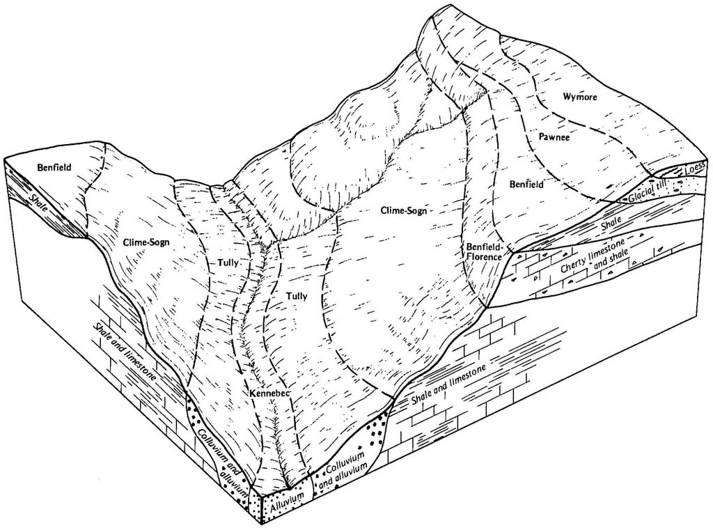
In this chapter, the soil survey staff define the term soil survey within the context of the NCSS in the US. They discuss the development of pedology (the study of soils in their natural setting) and the important concept of soils as natural three-dimensional bodies that form as a result of the interaction of five soil-forming factors. They state that the repeating patterns formed by these natural bodies of soil in the landscape allow soil scientists to develop predictive soil-landscape models, which serve as the scientific foundation for making soil surveys. The chapter concludes with important milestones in the development of the Soil Survey in the US.
Soil Survey Staff, USDA NRCS. 2018. “Web Soil Survey.” USDA NRCS. 2018. https://websoilsurvey.sc.egov.usda.gov/.
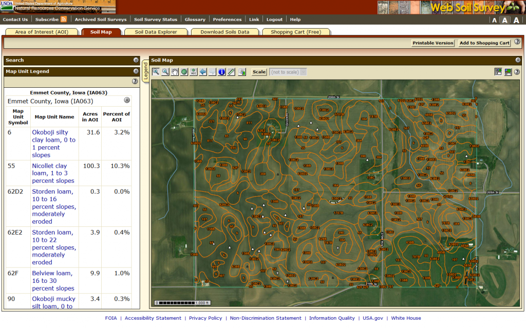
The Web Soil Survey is a simple to use web application that provides soil survey information to end users. This information includes customized soil maps, soil data, and interpretive soil maps for 95% of the counties in the US. The Web Soil Survey is an important tool that can be used in soil management at the field scale.

USDA NRCS. 2010. From the Surface Down: An Introduction to Soil Surveys for Agronomic Use. Second. Lincoln, NE: USDA. https://nrcspad.sc.egov.usda.gov/DistributionCenter/product.aspx?ProductID=449.
This publication should increase user understanding of soils and the content of soil surveys as well as supplemental interpretations important to agronomic programs. Proficiency in using soil survey data requires a basic understanding of the concepts of soil development and of soil-landscape relationships. The first three sections cover these basic concepts. The last five sections cover soil survey information and where to find information on soil properties.
USDA NRCS NSSC. 2018a. Web Soil Survey – Part 1: Application Access (2/2018). Lincoln, NE: USDA NRCS NSSC. https://www.youtube.com/watch?v=vxSW49ZK8vM.
This NRCS video is the first in a series of YouTube videos that explains how to use the Web Soil Survey. This video focuses on basic navigation from the Web Soil Survey homepage.
USDA NRCS NSSC. 2018b. Web Soil Survey – Part 2: Set Area of Interests (2/2018). Lincoln, NE: USDA NRCS NSSC. https://www.youtube.com/watch?v=bciIQrk3bjs.
This is Part 2 of the Web Soil Survey YouTube video tutorials. In it, the USDA NRCS presents how to use the Web Soil Survey . This video focuses on how to define an area of interest to create a customized soil report. The limitations in creating these custom reports are also discussed.
USDA NRCS NSSC. 2018c. Web Soil Survey – Part 3: Tabs and Downloads (2/2018). Lincoln, NE: USDA NRCS NSSC. https://www.youtube.com/watch?v=thWicmr1tp0.
This is Part 3 of the Web Soil Survey YouTube video tutorials. This tutorial focuses on how to download information, including soil data, for an area of interest for which users have created a custom soil map.


