3 Soil Erosion Processes
Colby Moorberg and Brooke Hogan
Abbreviations
ASA – American Society of Agronomy
CSSA – Crop Science Society of America
EPA – US Environmental Protection Agency
PDF – Portable Document Format
RUSLE – Revised Universal Soil Loss Equation
SSSA – Soil Science Society of America
URL – Uniform Resource Locator
US – United States
USDA – US Department of Agriculture
USLE – Universal Soil Loss Equation
WEPP – Water Erosion Prediction Project
WEPS – Wind Erosion Prediction System
WEQ – Wind Erosion Equation
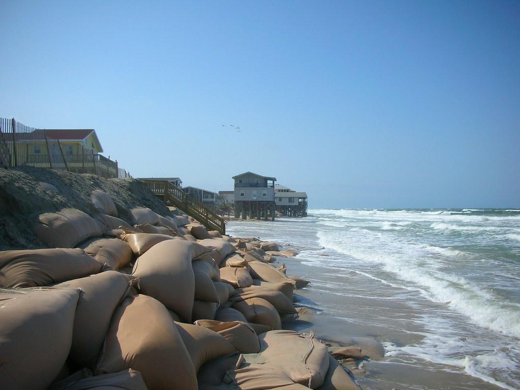
Coastal Erosion
National Research Council. 2007. “Chapter 2 Understanding Erosion on Sheltered Shores.” In Mitigating Shore Erosion Along Sheltered Coasts, 25–43. Washington, D.C.: The National Academies Press. https://doi.org/10.17226/11764.
This book chapter from the National Research Council includes information on the fundamentals of shoreline erosion. The chapter has three sections: “The Physics of Coastal Erosion,” “Spatially and Temporally Variable Factors Controlling Coastal Erosion,” and “Implications of Geomorphic Settings for Erosion Mitigation Strategies.”
Short, A. D. 2012. “Coastal Processes and Beaches.” Nature Education Knowledge 3 (10): 15. https://www.nature.com/scitable/knowledge/library/coastal-processes-and-beaches-26276621.
This Nature Education Knowledge Project web page uses an encyclopedia-style approach to convey concepts of coastal processes and beaches. Short provides concise summaries of major coastal processes, including wave generation and types, tides and tidal currents, wind and currents, sea level, and overviews of beach systems, beach sediment types and sources, beach subsystems, beach types, and barriers. This web page includes many relevant and useful photographs and figures, as well as additional reading.
Sloss, C. R., M. Shepherd, and P. Hesp. 2012. “Coastal Dunes: Geomorphology.” Nature Education Knowledge 3 (10): 2. https://www.nature.com/scitable/knowledge/library/coastal-dunes-geomorphology-25822000.
This Nature Education Knowledge Project web page uses an encyclopedia-style approach to describe coastal dunes. Sloss begins with an explanation of the classification of coastal dunes and explains primary dunes and secondary dunes. Primary dunes are the result of accumulated beach sediment. Over time, primary dunes are increasingly influenced by vegetation as they become isolated from the beach. Types of primary dunes include incipient, established, and relict foredunes. Eventually primary dunes become so cut off from the sediment supply and prevailing erosional processes from the beach that secondary dunes form. Secondary dunes include blowouts, parabolic dunes, and transgressive sand sheets and dunefields. Photographs and diagrams provide visual examples of each dune type. The webpage has references and recommended readings at the end.
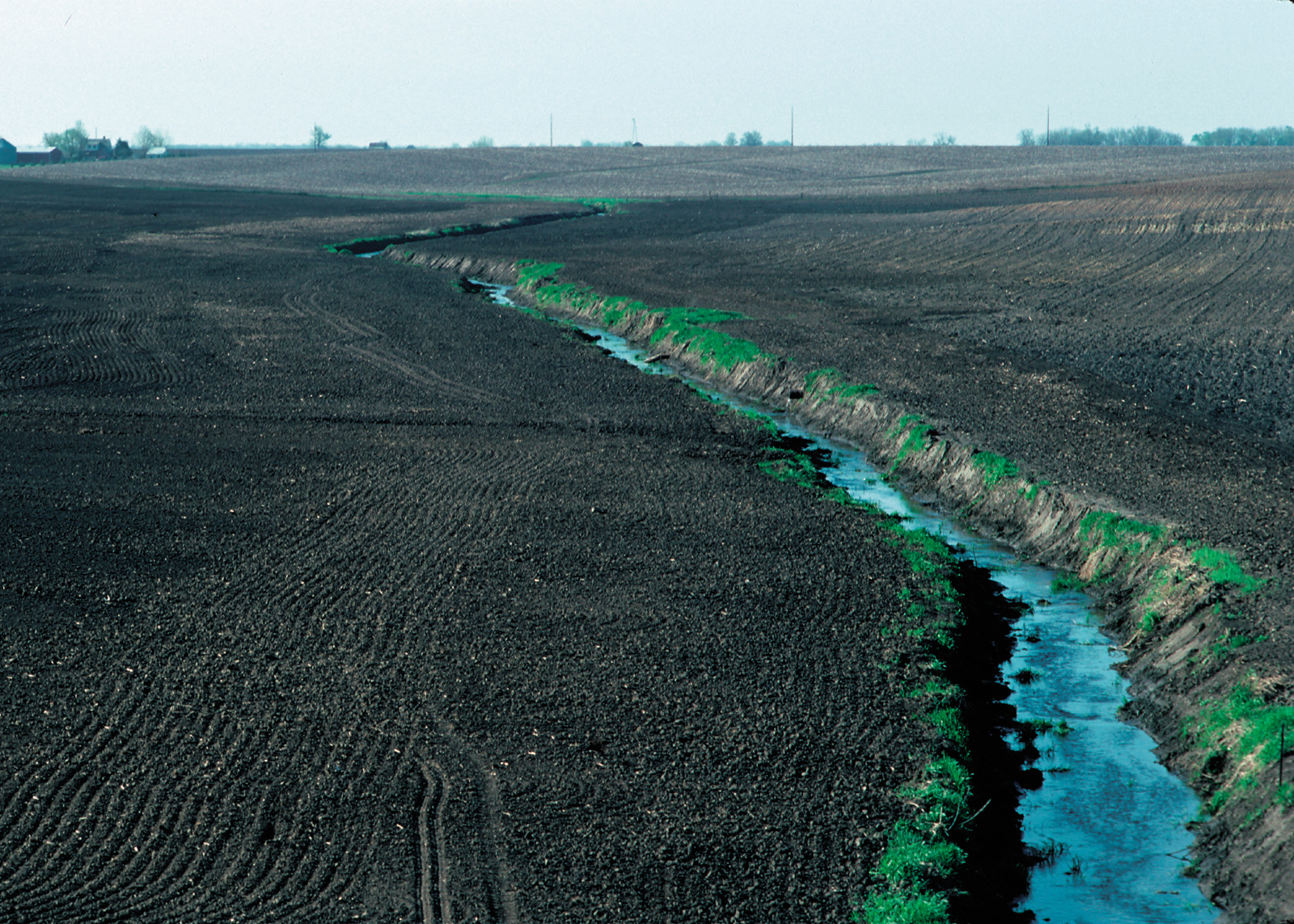
Streambank Erosion
Burnette, Matthew C., and Carmen T. Agouridis. 2014. “Streambank Erosion.” Extension Publication AEN-124. Lexington, KY: University of Kentucky. http://www.ca.uky.edu/agc/pubs/aen/aen124/aen124.pdf.
In this extension publication from the University of Kentucky, Burnette and Agouridis define streambank erosion, identify its causes, and explain why it is problematic. Then, they describe practices used to minimize streambank erosion and list relevant considerations for implementing these practices. Streambank erosion was identified as a source of concern because it leads to aquatic habitat destruction, loss of agricultural land, and safety issues. Among the methods to reduce streambank erosion are increasing stream access to the floodplain, reshaping the stream channel to direct flow away from the banks, and populating streambanks with deep-rooted riparian vegetation.
EPA Office of Water. 2007a. “Chapter 5: Streambank and Shoreline Erosion.” In National Management Measures to Control Nonpoint Source Pollution from Hydromodification, 5.1-9. EPA 841-B-07-002. Washington, D.C.: US EPA. https://www.epa.gov/nps/hydromodification-and-habitat-alteration-national-management-measures.
This chapter on streambank and shoreline erosion is in the EPA’s book, National Management Measures to Control Nonpoint Source Pollution from Hydromodification, a book intended to help assist states, tribes, and the public reduce nonpoint source pollution of surface and groundwater. Streambank erosion is a source of nonpoint source pollution with sediment and sediment-bound contaminants. The EPA lists and explains human activities that change stream characteristics, hydraulics, and/or morphology that ultimately contribute to streambank erosion. In this chapter, the EPA states that to stabilize streambanks, either vegetation or engineered structures may be used, noting further that the level of streambank exposure to severe erosional forces determines the method of stabilization. The EPA goes on to list tips and provide guidance in properly constructing and implementing stabilization structures and practices, including site preparation, practices to avoid, and maintaining structures or practices.
EPA Office of Water. 2007b. “Chapter 8: Modeling Information.” In National Management Measures to Control Nonpoint Source Pollution from Hydromodification, 8.1-19. EPA 841-B-07-002. Washington, D.C.: EPA. https://www.epa.gov/nps/hydromodification-and-habitat-alteration-national-management-measures.
This chapter from the EPA’s book, National Management Measures to Control Nonpoint Source Pollution from Hydromodification, contains descriptions of models that simulate and predict the effects of hydraulic and hydrologic changes on streams. The chapter includes two tables: one that describes models, and the other describes how to decide which model is most appropriate. The overall aim of the book is to assist states, tribes, and the public in reducing nonpoint source pollution of surface and groundwater. This chapter can be used to determine which model is most appropriate for making decisions related to reducing nonpoint source pollution from streambank erosion.
Wampler, P. J. 2012. “Rivers and Streams-Water and Sediment in Motion.” Nature Education Knowledge 3 (10): 18. https://www.nature.com/scitable/knowledge/library/rivers-and-streams-water-and-26405398.
This Nature Education Knowledge Project web page uses an encyclopedia style to convey concepts of water and sediment transport in rivers and streams. Sources are cited extensively, making the website a useful resource for additional readings and further exploring the topic. The page does contain a few images, though more figures and photographs would help communicate more effectively. In this page, Wampler describes how rivers are valuable to human civilization and the natural world, but also explains how human activities such as damming can disrupt a river’s capacity to provide ecosystem services. Wampler further states that such disturbances can be irreversible, and that restoration should rely on mimicry and soft structure rather than hydraulic engineering. Further, indicators like bed composition and channel slope can help in setting goals for improvement.
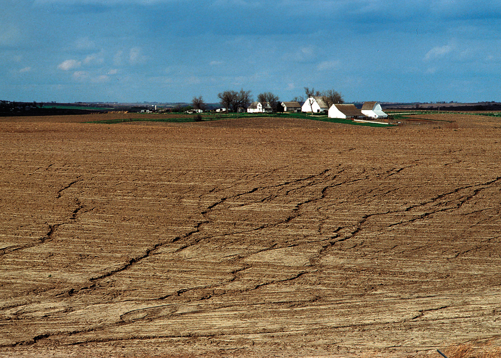
Water Erosion
Flanagan, Dennis C., John E. Gilley, and Thomas G. Franti. 2007. “Water Erosion Prediction Project (WEPP): Development History, Model Capabilities, and Future Enhancements.” Biological Systems Engineering: Papers and Publications, July. http://digitalcommons.unl.edu/biosysengfacpub/27.
In this peer-reviewed journal article, the authors document a detailed history of the development of the WEPP model, identify new modeling efforts at the time of publication, and comment on the impact and legacy of the model. The computer-based WEPP model has been substantially improved since its inception in 1985, leading to the current model capabilities for predicting water erosion as documented in this article.
Jones, A. J., D. Walters, W. G. Hance, E. C. Dickey, and J. R. Culver. 1988. “Universal Soil Loss Equation: A Handbook for Nebraska Producers.” EC88-116. Lincoln: Nebraska Cooperative Extension Service. http://digitalcommons.unl.edu/cgi/viewcontent.cgi?article=2620&context=extensionhist.
This 23-page extension bulletin from the University of Nebraska is a step-by-step guide to estimating erosion rates using the USLE. The target audience is Nebraska farmers although the information is applicable to other regions of the US, assuming soil K-factors and erosivity (R) values are available. The USLE model is a multiplicative model, meaning all factors are multiplied together. For the USLE model, the resulting product is the rate of soil erosion in units of tons per acre. This extension publication is dated, and the USLE is no longer supported or used by the NRCS. However, the concepts conveyed in this model make predicting soil erosion rates with the USLE a useful educational exercise.
Moorberg, Colby, and David Crouse. 2017. “Laboratory 8 – Soil and Water Conservation.” In Soils Laboratory Manual, K-State Edition, 66–76. Manhattan, KS: New Prairie Press. http://newprairiepress.org/ebooks/15.
This source is a laboratory exercise written for college students enrolled in introductory soil science courses. Students completing this exercise should be able to identify the conditions under which soil is most susceptible to wind and water erosion, estimate erosion rates using RUSLE, understand tolerable erosion rates known as T values, describe soil conservation practices, and identify agencies relevant to soil and water conservation. The laboratory activities include watching educational videos, completing calculations using RUSLE, and interpreting calculation results.
Ritter, J. 2012. Soil Erosion – Causes and Effects. Ontario Ministry of Agriculture, Food, and Rural Affairs. http://www.omafra.gov.on.ca/english/engineer/facts/12-053.htm.
This “factsheet” from the Ontario Ministry for Food, Agriculture, and Rural Affairs provides an overview of types of soil erosion. The bulletin outlines water erosion as well as other types of soil erosion, including streambank, wind, and tillage erosion. The bulletin outlines factors that influence soil erosion from water, including rainfall and runoff intensity, soil erodibility, cropping and vegetation, slope length and gradient, and tillage practices. The resources is available in web page format, or available as a downloadable PDF.
USDA ARS. 2016. “USLE History.” USDA ARS. August 12, 2016. https://www.ars.usda.gov/midwest-area/west-lafayette-in/national-soil-erosion-research/docs/usle-database/usle-history/.
This ARS web page presents the history of the USLE. The USLE is an empirical model developed to predict the annual rate of soil erosion. The web page begins with a general description of the USLE. This is followed by a history of soil erosion research in the US, a summary of federal conservation programs, and a concise history of the development of the USLE, including a timeline. The page also includes relevant historical photographs.
USDA ARS. 2017. “WEPP.” USDA ARS National Soil Erosion Research Laboratory. October 2, 2017. https://www.ars.usda.gov/midwest-area/west-lafayette-in/national-soil-erosion-research/docs/wepp/.
The ARS in West Lafayette, IN, oversees WEPP programming and updates made available to the public on this webpage. This webpage is a list of links to resources related to the computer-based WEPP model. This includes a download page with earlier versions as well as the most recent version of WEPP, version 2012.8. Other resources like documentation, release notes, and climate generator files are also listed.
Wind Erosion
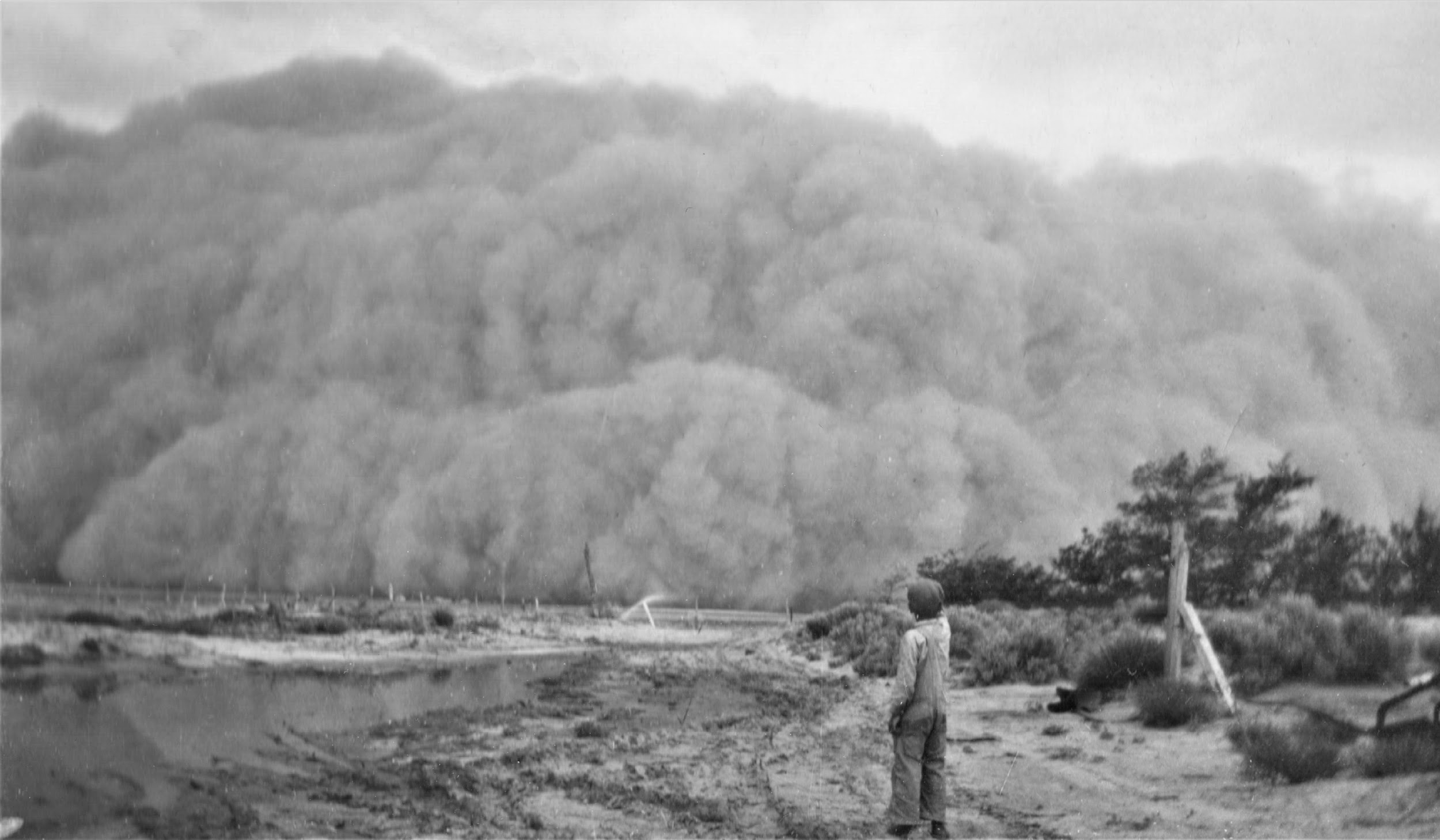
officemmdivide. 2011. Wind Erosion. https://www.youtube.com/watch?v=PQmon7Rj6ns.
Both water and wind erosion are explained briefly in this short video from the Land Conservation Assistance Network, a 501(c)(3) nonprofit that helps landowners sustainably manage wetlands, forests, and farms. The video defines erosion and explains why it is undesirable. Erosion rates under extreme conditions are provided for both water and wind erosion, giving context to the magnitude of erosion. Wind erosion is described in more detail, including the three types of sediment transport in wind erosion, along with an explanation for how wind erosion begins.
Tatarko, J., W. Trujillo, and M. Schipanski. 2019. Wind Erosion Processes and Control. 20. Colorado State University Extension. https://extension.colostate.edu/docs/pubs/crops/xcm180.pdf.
This extension bulletin from Colorado State University Wind summarizes the fundamentals of wind erosion. Wind erosion processes are described, as well as wind erosion control. Wind erosion processes discussed include wind, prevailing wind erosion direction, and the critical wind erosion period, as well as phases of sediment movement, and modes of sediment transport. Strategies for controlling wind erosion covered in this bulletin include vegetation and residues, permanent vegetative cover, surface roughness and aggregate stability, cross wind strip cropping, wind barriers, and emergency wind erosion control. Wind erosion models and research on wind erosion are also described.
Tatarko, J., L. Wagner, and F. Fox. 2019. The Wind Erosion Prediction System and its Use in Conservation Planning. In Bridging Among Disciplines by Synthesizing Soil and Plant Processes, 71–102. Madison, WI: ASA, CSSA, SSSA, Inc. https://www.ars.usda.gov/ARSUserFiles/24758/4.%20The%20Wind%20Erosion%20Prediction%20(002).pdf.
Wind erosion research was spearheaded by the USDA ARS following Dust Bowl. The empirical WEQ was established in 1965 and later replaced by WEPS to reflect recent research results and technological advances. This book chapter from Bridging Among Disciplines by Synthesizing Soil and Plant Responses includes a detailed description of the development of the WEPS model and documents the model structure and uses. WEPS has several uses: assisting land managers in reducing wind erosion, establishing soil loss tolerance in conservation plans, and determining erosion susceptibility of soils. The model operates using agricultural databases and user inputs to run a series of submodels, including hydrology, land management, soil type, plant growth, decomposition, and erosion. From this information, WEPS can simulate the effects of various conservation practices on erosion of soil by wind.
USDA NRCS. 2023a. Wind Erosion Prediction System (WEPS). https://www.nrcs.usda.gov/resources/tech-tools/wind-erosion-prediction-system.
The primary tool used to predict wind erosion is WEPS, described on this website from the USDA NRCS. This website includes download links to the most recent version of the model, as well as supporting files and links to related websites and WEPS training materials. The USDA ARS leads development of the WEPS model and supporting research on erosion. The focus of this USDA NRCS web page is to deliver the model to USDA NRCS field offices for official uses.
USDA NRCS. 2023b. Wind Erosion Training Reference Materials. https://www.nrcs.usda.gov/wind-erosion-training-reference-materials.
This USDA NRCS website provides a list of URL links to training materials for the WEPS model. The list includes links to a paper by Tartarko et al. (1999), a user manual, a quick start guide, example model runs, guidance on modeling with strip cropping and wind barriers, and archived WEPS training materials.
Warren, A., T. Gill, and J. Stout. 2018, July 3. Bibliography of Aeolian Research. https://www.lbk.ars.usda.gov/wewc/biblio/bar.htm.
This website provides over 40,000 references to reports, papers, and other resources from 1646 to 2015 that address aeolian research, which the site defines as “the study of the detachment, transport, and deposition of sediments by wind.” The citations are sorted by author.
