7 Leveraging Space for Disaster Risk Reduction and Management (Carter)
Student Objectives
- Impact of space disaster risk reduction and management in preventing climate change
- Explore the benefits of space disaster risk reduction and management during a global pandemic.
- To further understand the advances in space can lead to greater quality of life on Earth.
Introduction
Disasters can disrupt or devastate a community, society, or country. Disaster can cause human, economic, and environmental loss. This unpredictable event can drain resources hindering all aspects of recovery. This chapter provides an overview of how satellite data can prepare and respond to global disasters and emergencies. Space disaster reduction and risk management include removing hazards, reducing vulnerabilities, and reducing exposure. Before a disaster occurs, remotely sensed data provide information for systems and models that can predict disasters and provide early warnings (UNOOSA, 2022). This form of management supports the formulation of disaster scenarios to simulate the impacts of crisis events and test emergency procedures (Le Cozannet, G., Kervyn, M., & Russo, S., 2020). The Sendai Framework is the backbone of the United Nations Office Outer Space of Affairs mission for the adoption of using space in risk reduction and management. The framework focuses on adopting measures that address the three dimensions of disaster risk (exposure to hazards, vulnerability and capacity, and hazard’s characteristics) to prevent the creation of new risk, reduce existing risk and increase resilience (United Nations, 2015). The concept of space disaster reduction and risk management is not new; however, the world looked to this method to learn, monitor, and mitigate during COVID- 19. There are several benefits of space technologies for disaster management and response. The ability to share satellite data, communications, and applications provide real-time monitoring of our planet. Satellite data is critical in the event of disaster response and recovery. In 60 years, the planet went from zero space technology to today; nearly half of all countries have space capabilities.
The Sendai Framework For Disaster Risk Reduction 2015 – 2030
The Sendai Framework for Disaster Risk Reduction 2015–2030 was adopted at the Third United Nations World Conference on Disaster Risk Reduction, held in March 2015 in Sendai, Miyagi, Japan (United Nations, 2015). Currently, the framework is the only international accord for disaster risk management. The Sendai Framework embodies the following:
“…the need for improved understanding of disaster risk in all its dimensions of exposure, vulnerability and hazard characteristics; the strengthening of disaster risk governance, including national platforms; accountability for disaster risk management; preparedness to “Build Back Better”; recognition of stakeholders and their roles; mobilization of risk-sensitive investment to avoid the creation of new risk; resilience of health infrastructure, cultural heritage, and work-places; strengthening of international cooperation and global partnership, and risk-informed donor policies and programs, including financial support and loans from international financial institutions. There is also a clear recognition of the Global Platform for Disaster Risk Reduction and the regional platforms for disaster risk reduction as mechanisms for coherence across agendas, monitoring, and periodic reviews in support of UN Governance bodies’ (United Nations, 2015). The Sendai Framework and the Paris Agreement share a common goal of global coherence to climate change adaptation and disaster risk reduction. The agreements have a call to action for implementing policy and governance, using data and information, and monitoring/reporting standards. The Sendai Framework and the Paris Agreement encourage global partnerships to help governments develop solid risk financing strategies to respond to the impacts of climate-related disasters.
Climate Change
We can see evidence of climate change all around us, from the loss of arctic ice to the drying, wildfires increasing, and unprecedented changes in weather patterns globally. Scientists have proven the increase in human activities has caused the warming of the atmosphere resulting in devastating events. Evidence can be found in tree rings, ocean sediments, coral reefs, and layers of sedimentary rocks (NASA, 2022). Carbon dioxide from human activities is increasing about 250 times faster than from natural sources after the last Ice Age (Gaffney & Steffen, 2017). The advancement in satellites has allowed scientists to collect more data than ever before to assist in reversing damage to the planet.
NASA and international partners have the “A-Train” satellite constellation of Earth-observing satellites that follow along the same orbital track. Earth observation satellite-based remote sensing technology monitors land, marine (seas, rivers, lakes), and the atmosphere (EUSPA, 2022). The satellites have mounted payloads to gather imaging data about the Earth’s characteristics. The satellite can have an Optical or thermal sensor. These payloads can report on the energy received from the Earth due to the reflection and re-emission of the Sun’s energy by the Earth’s surface or atmosphere (EUSPA, 2022). They operate between the visible and
Figure 7-1 “A-Train” Satellite Constellation
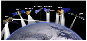
Source: (NASA, 2022)
Satellites use Infrared wavelengths of the electromagnetic spectrum (EUSPA, 2022). Also, satellites can use radar sensors to capture radiation emitted from the Earth’s surface. Earth observations in space deliver various data to improve space disaster risk management.
Figure 7-2 Burning in Botswana
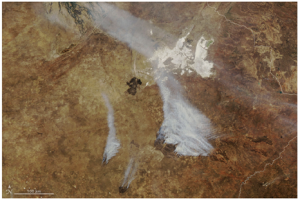
Source: (NASA, 2022)
Cities are increasingly experiencing the impact of climate change through extreme weather events, bushfires, flooding, storm surges, and sea level rise (Hurlimann, Moosavi, & Browne, 2020). Over half of the world’s 8 billion people live in cities, which is expected to increase by over 70% in the coming decades (EUSPA, 2022). Population increases directly impact the rise of temperature, bringing extreme heat events and raising the risk for dense population areas to be impacted by climate change. Being aware of the risk, urban planners use sustainable developers to provide mitigation strategies to reduce the impact of climate change on the population. Sustainable engineers use satellite-based remote sensing technologies and socio-demographic data to create heat threat maps to advise urban planners of areas that can adversely affect the population, energy production, agriculture, and transportation. Urban planners can take steps to protect citizens and infrastructure by changing traffic patterns, increasing green space, and encouraging alternative transportation.
Figure 7-3 Dubai Satellite imagery and LiDAR Digital Terrain Models urban strategic information about urban planning and prevention of flooding conditions in urban areas
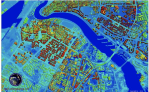
Source: (Satellite Imaging Corporation, 2022)
A Prague-based company, ECOTEN, uses data from various satellite programs combined with technology to assist with sustainable urban planning across Europe. EOCTEN is mapping highly vulnerable urban areas to reduce the risk of natural disasters (i.e., extreme heat events). Using this innovative method for risk reduction, Vienna is using the information to transform Zieglergasse in the 7th municipal district into a climate-adapted street. The densely populated area is modified with planted trees, several public water points, and light-colored paving. These climate-friendly changes have lowered the temperature and prevented the district’s flooding.
Figure 7-4 Zieglergasse – Vienna’s First Climate-Adapted Street
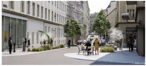
Source: (Okosvaros, 2020)
Damage Mapping After A Disaster
On December 26, 2004, the Indian Ocean tsunami was one of the deadliest disasters in modern history, with nearly 230000 people dead. In the days immediately following, the International Charter on Space and Major Disasters was activated. This initiated the gathering of satellite data over the affected region. The alliance carried out a large amount of rapid mapping in the immediate days to follow, creating over 210 individual maps from more than 19 satellites (European Space Agency, 2018). Crisis mapping continued for several days and the
Figure 7-5 Satellite map of the affected Sri Lankan coast
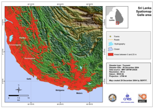
Source: (European Space Agency, 2018)
The next step would be mapping environmental damage, humanitarian aid, and rebuilding the region. The impacts of the 9.0 earthquake and tsunami were far-reaching across Indonesia, India, Malaysia, Maldives, Sri Lanka, Thailand, and Africa (DeepSea News, 2011). The satellite disaster mapping was able to identify the next environmental impacts:
- Solid Waste disaster debris and sewage
- Containment of soil and water
- Loss of infrastructure and Facilities
- Loss of natural ecosystems
- Notification of Coastal Waters
- Impact on biological communities and species
Solid waste and debris had an impact on all surrounding ecosystems. Given the mix of concrete, raw sewage, and other building waste materials, mixed were sent into the sea. The loss of life was believed to be over 100,000 souls. Once the damage assessment was complete, researchers requested a detailed vulnerability assessment of the region as part of the rebuilding effort. Poverty, structural design, and geological conditions were the top outcomes of the earthquake vulnerability assessment. Researchers considered secondary hazards such as landslides and fire. GIS mapping tsunami vulnerabilities included the ecosystem, structure, and social vulnerabilities.
Figure 7-6 Satellite Images Of Environmental Impact On Coast Post-December 26, 2004, Tsunami
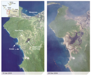
Source: (DeepSea News, 2011)
Figure 7-6 gave recovery management an overview of the environmental damage to northern Sumatra in Indonesia. The tsunami wiped out the low-lying delta land, destroyed fishponds, and removed coastal vegetation. The loss of this mangrove cover is critical; this tropical timber thrives in salty seawater. These tropical trees can store large amounts of carbon, a crucial component of fighting climate change. The images also show a pocket of missing silt and soil, which stores carbon, another protection from climate change. The sandy beaches have been removed (important in some locations for turtle nesting), and the deposition of silt or mud on the reef (DeepSea News, 2011).
Global Health
The passion for science, technology, and innovation combined with space manifested during the COVID-19 pandemic. The United Nations Office for Outer Space brought together the globe to work together to use information gathered from UN Member States satellite infrastructures to understand risks, drive policy, understand the spread of COVID-19, population movement, and communication. Pandemic times highlighted part of the capacity to use space for disaster risk management; maximum potential in all corners of the world is yet to come.
COPERNICUS
Copernicus is a component of the European Union’s space program, with funding by the EU, and is its flagship Earth observation program, which operates through six thematic services: Atmosphere, Marine, Land, Climate Change, Security, and Emergency. It delivers freely accessible operational data and services providing users with reliable and up-to-date information about our planet and its environment. The program is coordinated and managed by the European Commission and implemented in partnership with the Member States, the European Space Agency (ESA), the European Organization for the Exploitation of Meteorological Satellites (EUMETSAT), the European Centre for Medium-Range Weather Forecasts (ECMWF), EU Agencies and Mercator Ocean, amongst others. (UN-SPIDER, 2020). During the pandemic, Copernicus provided EMS Rapid Mapping for COVID -19. The rapid mapping produced dynamic satellite maps, continuous census of installed infrastructure, and merging with population data to check the actual level of usage versus expected in designing, assisting with the buildout of mobile and temporary hospital infrastructure. Early in the pandemic, Copernicus was key in monitoring boardercross after lockdown directives by European countries. Optical VHR Data geospatial reporting delivered real-time images of important traffic queues at the EU border areas (i.e., traffic jams, including the details of the number of trucks versus the number of vehicles not moving) (UNOOSA, 2020).
Figure 7-7 Copernicus monitors the impact of traffic congestion at border crossings between the EU Member States during COVID- 19
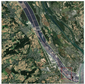
Source: (UNOOSA, 2020)
Images from Copernicus were used as a decision and support tool for policy definition to determine the opening of street markets, green areas, and parks. The satellite maps with access points, land use, and usable areas were merged with population data to project the maximum number of people who can stay in an area versus limits defined by law regulation of access points. Governments using Copernicus looked at satellite maps of open areas (i.e., parks) to understand access points collated with the surrounding population to formulate policies for a maximum number of people peruse the area. (UNOOSA, 2022)
Figure 7-8 Change in concentration of NO2, ozone, and particulate matter
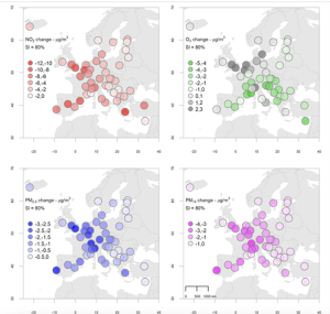
Source: (Atmosphere Monitoring Service, 2022)
Unique datasets originating from Copernicus Atmosphere Monitoring Service (CAMS) during the pandemic brought to light the level of air quality impacts back the length of life. By using observed changes in daily concentrations of the pollutants studied, combined with an assessment of people’s exposure, scientists estimate that a total of over 800 deaths were avoided with improved air quality resulting from the governmental measures taken to limit the spread of the SARS-Cov-2 virus (Atmosphere Monitoring Service, 2022). Paris, London, Barcelona, and Milan were among the top six cities with the highest number of avoided deaths (Atmosphere Monitoring Service, 2022). There was a reduction in road transport, leading to a decrease in Nitrogen Dioxide (NO2) by over half across European cities. Vincent-Henri Peuch, Director of the Copernicus Atmosphere Monitoring Service (CAMS), commented, ” …beyond the analysis of the mortality during the first months of the pandemic, this study could help shape future policy as the public health benefits of reducing pollution in our cities and the effectiveness of certain measures are clear to see,” (Atmosphere Monitoring Service, 2022).
The evolution of the COVID-19 pandemic in countries around the world using GIS and web-based dashboards, the wider reach of communication technologies, and the increasing availability of information technologies opened an opportunity for increased use of space-based solutions in these times of crises (UN-SPIDER, 2021)
Conclusions
Space applications related to telecommunications and global navigation can play a vital role in supporting disaster risk reduction, response, and recovery efforts (St-Pierre, 2016). Satellite imagery can help monitor the evolution of populations, infrastructure, and environment, offering the ability to contrast and identify vulnerabilities. Outer space can help be better prepared and reduce the volatility of the impacts of disasters. Collaborations across all nations to have the ability to access the data and develop plans for disaster preparedness are part of a piece of saving the planet from climate change.
References
Atmosphere Monitoring Service. (2022, January 26). More than 800 deaths may have been avoided due to air quality improvement during the first lockdown phase in Europe | Copernicus. Retrieved August 26, 2022 from Copernicus Atmosphere Monitoring Service: https://atmosphere.copernicus.eu/more-800-deaths-may-have-been-avoided-due-air-quality-improvement-during-first-lockdown-phase
DeepSea News. (2011, March 21). From the Editor’s Desk: The Environmental Impacts of Tsunamis. Retrieved August 27, 2022 from Deep Sea News: https://www.deepseanews.com/2011/03/from-the-editors-desk-the-environmental-impacts-of-tsunamis/
European Space Agency. (2018, December 12). A year on from the Asian tsunami, satellites are aiding regional rebuilding. Retrieved August 26, 2022 from European Space Agency: https://www.esa.int/Applications/Observing_the_Earth/A_year_on_from_the_Asian_tsunami_satellites_are_aiding_regional_rebuilding
EUSPA. (2022, August 26). Using Copernicus data to climate-proof cities. Retrieved August 26, 2022 from European Union Agency for the Space Programme: https://www.euspa.europa.eu/newsroom/news/using-copernicus-data-climate-proof-cities
- Le Cozannet, M. Kervyn, S. Russo, C. Ifejika Speranza, P. Ferrier, M. Foumelis, T. Lopez & H. Modaressi. (n.d.).
Gaffney, O., & Steffen, W. (2017, February 10). The Anthropocene equation. The Anthropocene Review, 4(1), 53-61. From https://journals.sagepub.com/doi/abs/10.1177/2053019616688022
Hurlimann, A., Moosavi, S., & Browne, G. (2020, August 13). Urban planning policy must do more to integrate climate change adaptation and mitigation actions. Retrieved August 24, 2022 from Science Direct: https://www.sciencedirect.com/science/article/abs/pii/S0264837720325266#:~:text=Well%2Ddesigned%20urban%20planning%20policy,change%20adaptation%20and%20or%20mitigation.
Le Cozannet, G., Kervyn, M., & Russo, S. (2020, March 10). Space-Based Earth Observations for Disaster Risk Management. Retrieved August 17, 2022 from NASA/ADS: https://ui.adsabs.harvard.edu/abs/2020SGeo…41.1209L/abstract
Lea, R. (2022, May 11). The History Of Satellites Explained. Retrieved August 22, 2022 from SlashGear: https://www.slashgear.com/860409/the-history-of-satellites-explained/
NASA. (2017, October 4). Oct. 4, 1957 – Sputnik, the Dawn of the Space Age. Retrieved August 22, 2022 from NASA: https://www.nasa.gov/image-feature/oct-4-1957-sputnik-the-dawn-of-the-space-age
NASA. (2022). Evidence | Facts – Climate Change: Vital Signs of the Planet. Retrieved August 10, 2022 from NASA Climate Change: https://climate.nasa.gov/evidence/
NASA. (2022, August 15). Recent Imagery Incorporating Aqua Data. Retrieved August 26, 2022 from Aqua Earth-observing satellite mission | Aqua Project Science: https://aqua.nasa.gov/
Okosvaros. (2020, July 30). Okosvaros. Retrieved August 12, 2022 from Vienna’s first climate-adapted street | Smart City: http://okosvaros.lechnerkozpont.hu/en/node/744
Satellite Imaging Corporation. (2022). Urban Planning | Satellite Imaging Corp. Retrieved August 26, 2022 from Satellite Imaging Corporation: https://www.satimagingcorp.com/applications/environmental-impact-studies/urban-planning/
St-Pierre, L. (2016, November 22). Outer space is driver for disaster risk management, sustainable development – UN expert. Retrieved August 27, 2022 from UN News: https://news.un.org/en/story/2016/11/546112-outer-space-driver-disaster-risk-management-sustainable-development-un-expert
Thiessen, M. (2022, May 19). Oct 4, 1957 CE: USSR Launches Sputnik. Retrieved August 22, 2022 from National Geographic Society: https://education.nationalgeographic.org/resource/ussr-launches-sputnik
U.S. Global Change Research Program. (2022). Understand Climate Change. Retrieved August 26, 2022 from GlobalChange.gov: https://www.globalchange.gov/climate-change
UNICEF. (2018, October 1). Deadly earthquake and tsunami hit Indonesia. Retrieved August 26, 2022 from UNICEF: https://www.unicef.org/stories/deadly-earthquake-and-tsunami-hit-indonesia
United Nations. (2015, March). Sendai Framework for Disaster Risk Reduction 2015 – 2030. Retrieved August 26, 2022 from PreventionWeb.net: https://www.preventionweb.net/files/43291_sendaiframeworkfordrren.pdf
UNOOSA. (2020, May 18). UNOOSA Space4Health Webinar – Afternoon Session. Retrieved August 24, 2022 from YouTube: https://www.youtube.com/watch?v=3d_hyutqu7s
UNOOSA. (2022, January). Benefits of space: Disasters. Retrieved August 26, 2022 from UNOOSA: https://www.unoosa.org/oosa/en/benefits-of-space/disasters.html
UN-SPIDER. (2020, March 11). Coronavirus disease (COVID-19) | UN-SPIDER Knowledge Portal. Retrieved August 24, 2022 from UN-Spider: https://www.un-spider.org/advisory-support/emergency-support/12182/coronavirus-disease-covid-19
UN-SPIDER. (2021, November 16). Space-based Solutions for Disaster Management in Africa: Networks and Information Technologies in times of crisis. Retrieved August 26, 2022 from UN-Spider: https://un-spider.org/sites/default/files/concept-note-un_spider-bonn-conference-2021.pdf
