12 Humanitarian Use of Space Technologies to improve Global Food Supply & Cattle Management (Larson)
Student Learning Objectives
The student will gain an understanding of how space technologies are being used to improve global food supply and cattle management. Concepts discussed include using space technologies for surveying and mapping, environmental stewardship, animal health, and filling labor voids in modern agriculture.
History of space technology used for agriculture
The development of human civilization occurred alongside the discovery of agricultural practices. As humans drifted away from the hunter-gatherer lifestyle, they developed science of growing and harvesting food. This shift in food accessibility allowed humans to produce food for a growing urban environment. Through the years, the labor-intense lifestyle of traditional agricultural practices has deterred people from the field. This labor shortage has presented itself as a barrier to increasing the food supply.
The demand for improved agricultural practices paved the way for the rise of smart agriculture. Smart agriculture is defined as the integration of innovative farming technologies used to increase the quantity and quality of agricultural products (Goel & Yadav, 2021). The movement is based on three platforms: science, innovation, and space technology. For smart agriculture to be successful, sensing technologies, software applications, communication systems, positioning technologies, hardware and software systems, and data analytics solutions must align for the enhancement of the food product supply system (Figure 12-1).
Figure 12-1. Components of a successful smart farming initiative
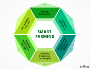
Source: (Sciforce, 2020)
Although few space technologies exist in the current market space without connections to these mentioned facets of smart agriculture, it is important to note that historically, it was not always the case. For example, the first satellite developed for remote sensing applications in the agricultural space is known as LANDSAT 1. The LANDSAT 1 satellite, launched by NASA, was used in agriculture to collect data estimating biomass (Yang, 2020) and crop output (Doraiswamy & Moulin, 2003). Although the implementation of this satellite in the agricultural space was revolutionary for the field of agriculture, its use had limitations. Limitations included spatial resolution of the imaging system, return visit frequency and a number of spectral bands available for analysis, and lacking integration of multiple remote sensor inputs. It did not consider input from sensors gathering data on soil monitoring (Sullivan & Shaw, 2005), water stress management (Zarco-Tejada, 2012), weed infestation (Gómez-Casero & Castillejo-González, 2010), chlorophyll and nitrogen content of leaf, crop height, plant species and growth rate (Castillejo-González, 2009); (Donoghue, 2007); (Enclona, 2004); (Peña-Barragán, 2008)). Other countries, such as India, saw the benefits of using space technology like LANDSAT for agricultural purposes and launched their satellites regardless of the limitations.
Integration of multiple sensor inputs presented a monumental shift in the application of space technology for agricultural purposes. A multiple sensor approach enhances output precision to capture better the multi-factor decision-making process food producers are tasked with. Applications in the agricultural space began to demand more than remote sensing platforms like satellites and unmanned aircraft vehicles (UAV). Integration of remote sensors (for example, optical and near-infrared (NIR) sensors or radio detection and ranging (RADAR)) changed the potential for what information the remote sensing platforms could deliver to the producer. In addition, spatial resolution improved, and return frequency increased, allowing satellite platforms to gather more data with increased accuracy. The shift from basic image gathering toward data analysis of multiple sensor inputs defines the needs of the precision agriculture movement. By enhancing the precision and effectiveness of agricultural practices, food producers are enabled to optimize environmental conditions to maximize crop yield, resulting in more food production per unit of land.
Key areas of success in implementing space technology in agriculture
Those involved in the agriculture industry have prided themselves on being stewards of the land for generations. Farmers take pride in understanding that “today’s generation must protect and nourish the environment for the betterment of today and tomorrow’s generation” (Bansod & Singh, 2017). Implementation of space technology, in particular, the partnership of satellite remote sensing and proximal remote sensing, provides opportunities for increased food production using methods that work to enhance previous land stewardship practices. This section will discuss key areas of success when implementing space technology into the field of agriculture in two loose groups: geographical information systems and remote sensor monitoring (specifically applications of on-farm weather sensors).
Geographical information systems – Surveying and mapping
Geographical information systems (GIS) represent the original implementation of space technology in the field of agriculture. The use of satellites and UAVs for monitoring in the agricultural space continues to emerge as technologies that can deliver value to the food production industry enter the market space. Three categories loosely define areas of success for current and emerging GIS technologies with application to agriculture: surveying and mapping, environmental pollutant monitoring, and circumventing labor challenges in agriculture.
Surveying and mapping capabilities have been greatly refined since the original days of LANDSAT 1. The big-picture perspective of satellite imagery has long exercised its effectiveness in creating topographical maps of remote agricultural regions. With the additions of proximal GIS technology such as UAV and multiple sensor inputs into these GIS technologies, capabilities to deduce more than the basic topographical map has emerged. Multiple data inputs provide insight to geographically inform the producer on variations in soil type and quality, water saturation, and plant density. Unmanned ground vehicles (UGV) have been designed to autonomously navigate agricultural regions using GPS coordinates while pulling samples and relaying information on present conditions. Figure 12-2 shows a UGV prototype developed specifically for automated soil sampling to examine nutrient content’s presence and deduce the need for fertilizer and water within the designated sampling region (Vaeljaots, 2018). Understanding the nutrient presence, soil type, and water holding capacity better enables producers to understand the needs of their agricultural region by providing information to describe how many plants that plot of land can support. This cascades to many decisions made by the producer during the food growing period, such as how close to place seeds when planting, how much water is needed to be applied using irrigation technology, and whether or not additional fertilizer needs to be applied to support plant growth nutritionally.
Figure 12-2. Unmanned ground vehicle designed for autonomous soil sample collection by Estonian University of Life Sciences
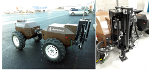
Source: (Vaeljaots, 2018)
Data analytics are used to aid the decision process in smart agriculture. Analysis of the various sensor/sampling outputs is sequentially inputted into satellite mapping to create management zones that may use different strategies (for fertilizer application, water requirements, or pesticide application) to maximize crop yields in that area.
Although the use of UAV and UGV is likely to continue in the agricultural space for the collection of field-specific data, satellite technology has the potential to limit the complexity of data collection protocols (e.g., number of sensor inputs) if the image quality provided has proven computationally stable to provide the insight required (Meyers & Dokoozlian, 2020). Determining which imagery platform is used (Satellite or UAV/UGV) depends largely on spatial accuracy needs and consumer willingness to pay. When equipped properly, UAV/UGV has demonstrated an ability to deliver high spatial accuracy and is effective for surveying smaller target regions. However, there has been less development to date on standardized procedures in the data analytics space. In comparison, satellite imagery is generally lower resolution, but satellite capabilities to revisit in equally spaced intervals without weather restrictions (e.g., wind, precipitation) that negatively impact UAV (except for cloud level factors) to provide consistent autonomous data (Comparetti, 2022).
Emerging technologies integrating data from UAV/UGV sensors with satellite mapping capacities are gaining interest in the precision agriculture market space. Variable Rate Technology (VRT) allows producers to customize the application of fertilizer, seed planting density, irrigation quantity, and pesticide applications to the sensor-identified needs of the sampled agricultural region. Satellites play a critical role in producing within-field maps to create the spatially variable rate input application maps to be used by GPS monitored equipment (see Figure 12-3; (Comparetti, 2022) allowing UAV/UGV to provide additional sensor inputs to define the agricultural region. By identifying regions requiring alternative management conditions, food producers can better maximize the quality and quantity of the food grown in those regions. In certain regions, the automated characterization of specific management needs could mean producing a more uniform crop and maximizing the profit of high-value food products, while in other regions of the world could be the difference for a population attempting to produce enough food to sustain themselves through non-growing seasons. The global implications of GIS technologies for surveying designated agricultural regions present unique opportunities in the agricultural sector to enhance global food supply – quantitatively and qualitatively, depending upon the designated market. As the market for connected sensors connected to GIS technologies continues to grow, the “smart agriculture” movement and enhancement of space technologies for agricultural applications will continue to provide novel solutions for increasing global food supply in a way that maintains the expectation for land stewardship set forth by generations of farmers before.
Figure 12-3. Spatially variable rate fertilization map in a Sicilian vineyard developed using Sentinel-2 Satellite. Two management zones are represented: black cells representing areas of high vegetative vigor and high-water content; white cells representing areas of low vegetative vigor and low water content.
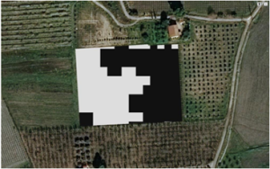
Source: (Comparetti, 2022)
Geographical information systems – Environmental Stewardship
Emphasis placed on the importance of environmental stewardship by food producers ensures technological advancements using GIS technology for monitoring environmental pollutants will be a continuous field of interest. Various laws highly regulate agriculture in the United States, acts, and guidance documents encompassing many facets of agricultural operations (United States Environmental Protection Agency, 2022). Regulation exists for aquaculture discharges; concentrated animal feeding operations’ water use and manure disposal; cropland pesticide application and use; farm facilities, fuel, and equipment compliance; and a few.
The satellite used for emissions detections is currently being used in many facets: climate, natural disasters, health, and air quality, water resources, and others. Models such as the United States Environmentally-Extended Input-Output model (USEEIO) used by the EPA “melds data on economic transactions between 389 industry sectors with environmental data for these sectors covering land, water, energy, and mineral usage and emissions of greenhouse gases, criteria air pollutants, nutrients, and toxics, to build a life cycle model of 385 US goods and services” (Yang, 2020). Efforts by EPA have begun to automate the environmental compliance inspections by deploying unmanned aircraft systems (UAS) technology equipped with high-resolution imagery, geophysics and remote sensing, and gas sensors. Data from sensor-equipped UAS is transmitted in real-time using the ERT VIPER monitoring system for data analysis and visualization by the user (United States Environmental Protection Agency., 2022).
With the EPA using this level of detail in their risk-benefit-based analysis, the agricultural industry must maintain a high level of control on agricultural operations related to regulated activities. Activities in particular that demand increased precision are the application of pesticides to cropland, application of inorganic fertilizer as well as manure based on nutrient quantity, and irrigation of crops. The use of UAV technology for applying pesticides, especially when integrated with VRT using satellite GIS mapping, provides food producers with valuable tools to maintain compliance by only targeting areas infected with pests or where the disease is present. Figure 12-4 depicts an example of leading-edge aerial technologies pesticide applicator UAV. Hurdles for initial vehicle system development of this emerging technology described the weight of the pesticide solution as challenging for the UAV to carry and influencing vehicle control. Therefore, the integration with spatial GIS mapping for VRT was monumental for reducing the total quantity of products needing to be applied in the field. The use of VRT to guide UAV pesticide application serves as a benefit for both reducing environmental pollutants and decreasing costs for the producer, all while increasing crop yields due to pest and disease management (Hafeez, 2022). The ease of implementation decreased human exposure to chemicals, and increased product effectiveness with less environmental contamination has made producer uptake of this product successful. The global market size for agricultural drones in 2020 is estimated to be USD 0.88 billion, with projections supporting the market reaching USD 5.89 billion by 2030 (Wankhede, 2021).
Figure 12-4. Image of Precision Vision 35X as an example of an unmanned air vehicle (UAV) with pesticide application abilities in the agricultural space
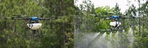
Source: (Reynolds, 2022)
Beyond pesticides, another area of stewardship that farmers have long been concerned about is fertilizer management. While fertilizer application using technology equipped with VRT drawing from satellite mapping and GPS control is present in the market and readily available by service providers. Estimates of adoption were 81% of producers in the United States applying single nutrients using VRT technology in 2017 (Lowenberg‐Deboer, 2019). The critical point to highlight concerning the success of VRT inorganic fertilizer application is the concept that each nutrient is being applied individually. Growing crops to maximize yield requires a specific ratio of nitrogen, phosphorous, and potash, which can vary based on the type of crop the producer intends to plant that year. When applied individually, the producer can calculate the need for each nutrient to be added based on what nutrients are present in the soil samples. However, when working with more complex fertilizer sources, such as manure or compost, where all three required nutrients are present, producers must apply based on the soil’s need for one of those nutrients. So there may be an over or under abundance of one of the other two nutrients. This adds a level of complexity when studying the effectiveness of VRT for manure applications. The variation in the success rate of meeting crop nitrogen needs has been explained as one of the reasons for the limited uptake of the technology in the livestock manure space. Still, phosphorus data has been promising (Mallarino, 2010). Equipping UAVs with emerging imaging and sensor technology capable of correlating plant nitrogen status to projected grain yield adds versatility for producers looking to apply manure or inorganic fertilizer (Maresma & Ariza, 2016). In the Geographical information systems – Surveying and mapping section of this chapter, the use of UGVs for collecting soil samples integrating with GIS mapping capabilities was described. It’s important to note the environmental stewardship story when using space technology’s role in UGV soil sampling paired with satellite map creation. Most obviously, when mapping capabilities are integrated with multisensory inputs (such as soil analysis, water content, etc.) and used for variable rate application of fertilizer and water improvement, the efficiency of the tillable land is increased. Within the constraints of the earth’s atmosphere, the quantity of tillable land has little room for drastic increases without other severe environmental impacts. Therefore, an increase in tillable land efficiency should be considered an exceptional benefit to feeding the growing world population.
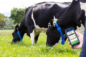
However, the land stewardship story extends beyond increasing efficiency and yield. The big picture capabilities to create a map conscious of the environment surrounding the agricultural region help food producers better integrate solutions for limiting erosion, protecting endangered ecosystems, as well as understanding sources of fertilizer runoff into the surrounding natural ecosystem. Conservation groups are partnering with cattle producers to understand better the stewardship story that space technology is creating on the Kansas Prairie. Third-generation rancher Daniel Mushrush joined a nature conservancy project partnered with Kansas State University to explore the application of emerging space technology to cattle management for two main reasons: labor and maintenance challenges with traditional fences as well as a “moral obligation to treat [Flint Hills grass] like it’s sacred. Because it is. There’s not much left.” (Llopis-Jepsen, 2022). The initiative examines emerging technology that uses GPS technology to create virtual cattle fences. The project’s goals are to evaluate: “whether the devices can save ranchers money and simultaneously help ailing bird populations, reduce water pollution and increase the resilience and diversity of grasslands” (Llopis-Jepsen, 2022). Figure 12-5 depicts a cow from Mushrush’s herd wearing a GPS-equipped collar that guides the animal using satellite-derived GIS mapping technology (Llopis-Jepsen, 2022). Using this technology, cattle producers have the ability to set and move virtual fences to consider the stage of grass growth (i.e., food availability for cattle), accommodate the presence of disappearing species (e.g., prairie chickens), reduce the number of time cattle spend near bodies of water (i.e., reduce erosion induced by cattle trampling riverbanks), and various other applications depending upon cattle operation.
Figure 12-5. Red Angus cow wearing a GPS-equipped collar that responds to virtual fencing boundaries created using satellite-derived geographical information systems maps controllable virtually by the cattle producer
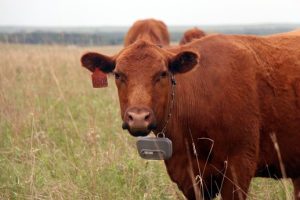
Source: (Llopis-Jepsen, 2022).
In an interview with Ben Veres, Chief of Staff, and Jeff Kafka, Director of Sales and Business Development for Vence, sustainability was mentioned as the greatest area of impact from using space technologies like virtual fencing. “Minute-by-minute GPS data can be paired with soil and vegetation data to paint an incredibly rich picture of the impacts of cattle on the landscape. There is often a lot of blame placed on livestock for grassland degradation – but without real cattle location data, the analysis is one-sided” (Veres, 2022). Opportunities for the use of virtual fencing technology were forecasted to evolve in 3 phases: Tracking (i.e., GPS location of animals), fencing (i.e., reducing physical fencings limitations and decreasing cost and labor), and animal health (which will be further discussed later in section: Integration of space technology into cattle management). Veres and Kafka state, “All of these things combined can create a much richer feedback cycle for the rancher – not only can they see where and how their cattle are doing, but they can easily adjust the cattle’s grazing plans and monitor the impacts of these changes. The feedback cycle is also much shorter – on large ranches, some cattle will go months between check-ins. This technology allows ranchers to be closer with their animals” (Veres, 2022). With regulative agencies like EPA incorporating space technology into the surveillance of environmental stewardship practices, emerging technologies like virtual fencing arm food producers with the power of knowledge to accurately diagnose and provide solutions for environmental challenges in their operations.
Geographical information systems – changing labor force in agriculture
Ryan Cryan, a chief economist for the American Farm Bureau Federation, captures the industry status well with his statement, “American Agriculture has every resource to grow and prosper and contribute to global food security – except for labor” (Bacon, 2022). The disappearance of the family farm, decrease in interest in the rural lifestyle and increase in mechanization contribute to the 76% reduction in self-employed and family farm workers seen between 1948 and 2017 (Wang, 2022). However, data also suggest that agricultural output increased by nearly 187% (Wang, 2022). Much of this success can be attributed to developments in technology. Precision technology reduces labor hours of the agricultural workforce for labor-intensive tasks while opening opportunities for skilled labor to enter the agricultural space in other ways (e.g., to maintain and operate implemented technology). In 2017, 40% of farm labor hours worked were executed by workers with at least some college education, compared to 4% in 1950 (Wang, 2022). Implementation of autonomous and semi-autonomous GPS monitoring equipment has been one of the most widely recognized successes in this area. While John Deere’s autonomous tractor reveal in 2022 still has space reserved for a driver, it will no longer require a driver presence to operate its desired tasks. Automating tasks such as preparing the ground for planting and, perhaps one day, even more complex tasks such as planting or harvesting play a large role in helping change the labor force required in agriculture. In the livestock space, similar emerging technologies are entering the market space. Still, as a whole, the industry is behind the crop production sector due to challenges with the costs of implementation. Examples of technology emerging in the livestock space will be provided later in this chapter in the section: Opportunities for integration of space technology into cattle management.
Regardless of the agriculture industry sector to which these emerging technologies are applied, they play a key role in removing barriers to human labor requirements, increasing the accuracy of planting and harvesting, and improving the efficiency of time spent on tasks. These contributing factors are convincing evidence for demonstrating how emerging precision technology adds value to the agricultural industry and increases the global food supply.
Remote sensors for weather monitoring
Since the Farmer’s Almanac, the impact of weather on food production has been heavily respected in agriculture. With the increasing uptake of smart agricultural practices, a growing interest by both producers and agricultural tech companies in personalizing weather-related information to specific agricultural operations emerged. Personalization of weather-related data has significant value to food producers, especially for rural locations where the closest weather tower collecting information may not be pertinent for real-time weather-related challenges. Implementing on-site weather sensors provides food producers with information that can optimize irrigation schedules and determine the best timing to plant and apply fertilizer. Figure 12-6 shows an in situ weather sensor marketed by OneSoil with capabilities to monitor soil temperature and moisture as well as air, barometric pressure, and illumination every 2 to 30 min on the farm (Timmermans, 2022).
Figure 12-6. OneSoil Agricultural in-ground weather sensor monitors soil moisture and temperature
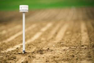
Source: (Timmermans, 2022)
Beyond using this technology as a stand-alone offering to producers, perhaps more valuable is the integration of weather sensors into data analytics platforms for interpretable producer outputs. Agricultural giant John Deere has demonstrated this value with their mobile weather technology. This sensor technology (Figure 12-7) feeds information to the producer interface (Figure 12-8) to guide the equipment when applying crop protectants according to regulations and maintain compliance and quality record keeping (John Deere., 2022).
Figure 12-7. John Deere Mobile weather sensor technology mounted on the hood of self-propelled sprayer
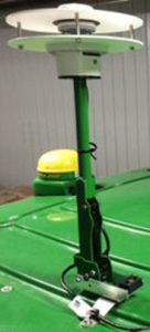
Source: (John Deere., 2022)
Figure 12-8. John Deere mobile weather technology user interface
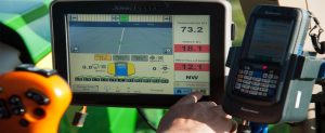
Source: (John Deere., 2022)
The value of real-time recognition of weather events can prove extremely valuable to food producers, especially when coupled with personalized data analytics output, measurements of wind speed and direction, temperature, humidity, rainfall, and on-farm producers with the knowledge to maintain environmental compliance standards and put emergency preparedness plans into place if necessary. For livestock producers, in particular, storm management plans are a key tool to maintain animal welfare standards when technology cannot overcome the forces of nature (e.g., power outages, significant snowfall or flooding, high winds, or significant heat events). Food producers in the livestock space are obligated to their animals, extending beyond whatever mother nature throws them. Standardization of data analytics procedures with recognizable producer indices, such as the Livestock Weather Safety Index (LWSI), allows universal use and interpretation of remote weather sensor technology data (Mader, 2006).
Integration of space technology into cattle management
Much like many of the agricultural solutions presented in this chapter, space technologies used in cattle management also rely on incorporating multi-sensor inputs for successful integration into the market space. Like crop and produce production, cattle management practices present numerous opportunities for emerging space technologies to impact the industry. Space technology has opportunities for success in the cattle industry because:
- Animals are primarily housed in outdoor areas (e.g., satellite and UAV technologies can access the region with limited interference)
- Industry labor shortages with limited automation present (e.g., unlike the skilled labor shift that’s occurred in other parts of agriculture, the lack of basic laborers has forced skilled laborers to be used inefficiently for more entry-level roles rather than what they were trained for)
- Complex animal health concerns (e.g., complex pathogens like those causing Bovine Respiratory Disease can be challenging to identify during ideal treatment windows)
- Navigation of environmental regulations (e.g., Regulations for manure and water are monitored closely in the cattle industry)
- Longer time to market and greater monetary value of an individual animal compared to other livestock (e.g., the longer period spent in the feedlot presents a greater risk for something happening to a high-value animal)
Although there is room in the market for developing technologies to assist the cattle industry, skepticism does plague this industry due to high investment costs. Therefore, understanding and demonstrating the valued added proposition of emerging technologies in this space is critical for developers. This section will focus on three key areas of space technology development for cattle management: satellite systems, remote health sensors, and feed management equipment. The technology mentioned in this section is not an exhaustive list and includes examples of both space-based technologies and remote sensors for integration with space technology offerings.
Emerging cattle management technology: satellite systems
Satellite systems have two main functionalities explored most commonly with application to cattle management: GPS monitoring and imagery. The direct use of GPS monitoring cattle via the virtual fencing industry has been described earlier in the section: Geographical information systems – Environmental Stewardship. It is important to emphasize that despite its implications for environmental stewardship, for virtual fencing to continue uptake by industry producers, it must continue to demonstrate value to cattle feeding operations monetarily. Eliminating costs of labor and supplies for fence management is a key benefit, especially for cattle grazing in the remote country when human access is challenging. Another potential output of the technology that broadly opens the targeted market is the recognition of cattle movement for animal health purposes. Changes in movement patterns of animals could detect calving status, disease presence, or dangerous threats (e.g., predator, environmental barriers, etc.). Access to this information helps cattle producers understand when intervention is necessary (Handcock, 2009).
GPS technology application to animals is arguably not in its infancy in the market like other technologies discussed in this chapter. GPS technology has been applied to animals since its emergence in the citizen space, specifically for ecologists’ and conservationists’ use in tracking terrestrial wildlife. But, commercialization of the technology for cattle has since accelerated the development of its capabilities beyond simple measurements to include animal behavior inferences (e.g., grazing, traveling, and resting activities) (Ungar & Henkin, 2005). Correlation of herd movement and activity with satellite imagery to predict biomass available using standardized vegetation indices (VI) provides producers even more information on decisions herds are making and where they are choosing to spend their time, especially for animals grazed in remote locations (Figure 12-9; (Handcock, 2009)).
Figure 12-9. (a) Movement of 36 cattle over three days in GPS-monitored paddock. (b) percentage of time spent in the region represented by pixel in satellite image (c) overlay of movement of cattle with normalized difference vegetation index (NDVI)
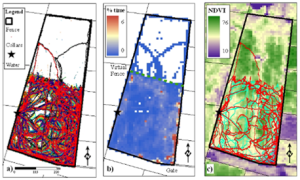
Source: (Handcock, 2009)
Data analytics have taken the interpretation of these satellite images a step further. Live weight gain prediction capabilities have been explored for cattle grazing paddocks using satellite-derived VI data as primary data input for the model (Pearson, 2021). There is great value for cattle producers to understand the biomass available. Knowing the quantity of vegetation available for grazing (and the potential to translate to an animal weight change) provides the cattle producer with an understanding of when additional management interventions (e.g., supplemental feed during dry season) are needed.
Emerging cattle management technology: remote health sensors
The ability to identify animals feeling unwell within the treatment window to ensure disease will not have lasting impacts on that animal’s life is truly an art. Finding (and retaining) labor with this valuable skill set in the cattle industry is proving harder than the art itself. In response to this animal welfare concern, agriculture technology companies and animal health companies have partnered to develop a variety of sensors that can simplify disease detection methods. “There will always be a need for skilled producers to engage with and deeply understand the cattle they are raising. No technology will replace the need for ranchers to get their hands dirty. Rather these technologies will be tools that will assist them in those efforts” (Veres, 2022). QuantifiedAg Tag is part of the SenseHub customer offering by Merck Animal Health. The smart tag (Figure 12-10) measures temperature and animal activity and has an LED indicator light on a tag to easily identify animals for treatment (Armstrong, 2016). The information collected by sensors built into the animal’s ear tag is relayed to a user interface where a list of animals needing treatment is located. To ease cattle handling, animals with values outside baseline for temperature and activity trigger an LED light on the ear tag making sick animal identification much more straightforward for cattle operation workers.
Figure 12-10. QuantifiedAg Tag measures animal temperature and activity level to provide inputs for the producer interface, where a list of sick animals to treat is generated. The indicator light on the tag identifies which animals need treatment.
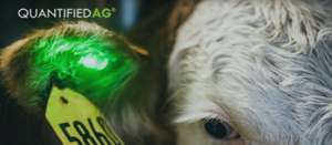
Source: (Armstrong, 2016)
MOOnitor is a collar equipped with sensors for measuring resting, feeding, rumination (i.e., chewing cud), head position, and restlessness of each animal, as well as monitoring for optimal breeding time (Figure 12-11). These sensor outputs relay back to the user interface, giving the producer a snapshot of the animal’s overall health. The sensitivity of MOOnitor sensors paired with its GPS module for movement tracking has proven to have the accuracy, precision, sensitivity, and specificity for effectively differentiating behaviors such as standing, lying, standing and ruminating, lying and ruminating, walking and walking, and grazing (Dutta, 2022). Effectively recognizing animal movements indicates that these remote health sensor technologies may be very effective in determining cows’ optimal breeding time, identifying disease presence, and/or detecting deviation from the herd’s baseline health standards.
Figure 12-11. MOOnitor collar is equipped with remote sensors as well as a GPS module for measuring animal movement, feeding, rumination, head position, etc. for monitoring general animal health as well as detecting optimal breeding time for females
Source: (Fox, 2019)
With the animal agriculture industry under a microscope by the public media concerning the treatment of animals and animal health standards, implementing these types of remote sensor technologies will hopefully arm producers with data related to animal welfare standards within their operation. Perhaps most impactful to the cattle producer is these tools’ ability to circumvent challenges that exist with skilled labor shortages for on-farm animal health management.
Emerging cattle management technology: feed management equipment
In the beef feedlot sector, a critical role for skilled labor is an employee with the ability to “read bunks” – a process by which the animals’ feed trough is inspected for the presence of the previous day’s feed offering. Based on the bunk score assigned by the bunk reader, the feed offered to that cattle pen could increase or decrease in the present day. Reading bunks is a time-intensive step in cattle management for large operations with limited labor. The accuracy of the call is also critical as feed costs are the major expense to any cattle operation. The critical nature of this task has piqued the interest of multiple agriculture technology developers. Efforts to develop computer visioning for bunk management with stationary cameras have succeeded with prediction accuracies for detecting the quantity of feed in the bunk (accuracy of prediction ranged from 81.8% to 90%) (Dorea, 2019). Accuracy of prediction of cattle behavior using the same technology resulted in a lower range with increased variability (accuracy of prediction ranged from 66.6% to 86.6%) (Dorea, 2019). However, these results are not surprising. Detection and analysis of a moving target (such as a live animal) is not an easy feat for any technology. Still, it is understood by agricultural workers that understanding cattle behavior at the bunk is just as important as the amount of feed remaining.
A patent granted to Digi Star LLC in 2019 but not yet available in public market space explores the idea of using UAVs equipped with sensor technology to automate bunk reading (Figure 12-12). The UAV sensor output is then relayed back to a feed delivery truck to dispense the intended amount of feed for that group of animals based on the previous day’s remaining feed (Patent No. Agricultural drone for use in livestock feeding. In: Google Patents., 2019). Although truly innovative in its field, the delay in development may be limited producer interest in the uptake of UAV technology for critical daily tasks – as weather may create an environment unfit for UAV operations. Still, bunk calls must be made regardless of the weather.
Figure 12-12. Explanatory diagram of the use of unmanned air vehicle (UAV) to determine feed remaining in cattle bunk with capabilities to relay real-time information to feed delivery truck
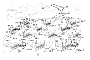
Source: (Patent No. Agricultural drone for use in livestock feeding. In: Google Patents., 2019)
One of the pioneer space technologies in cattle management is the use of GPS guiding feed truck equipment. Micro Technologies launched their first GPS-guided Feed Truck System, integrated with interfacing capabilities between feed truck computer and feed truck scale, in 1998 (Micro Technologies: Our History – Innovation in Motion. , 2022). This technology was revolutionary for decreasing the skill required to accurately deliver the correct amount of feed – saving time and money associated with incorrect feed deliveries. As regulations of in-feed animal drugs have tightened after the passing of the veterinary feed directive, the GPS-monitored Feed Truck System has ensured that drugs are being dispensed to the correct group of animals in the correct amounts – increasing the accuracy of record keeping with regards to animal health drugs.
Micro Technologies continues offering cattle producers at the forefront of precision agriculture. In 2022, they announced the launch of Accu-Trac Vision – a truck-mounted arm with a sensor detecting feed left in the bunk (Figure 12-13). This sensor output relays the bunk call to the feed dispatch center, guiding the feed delivery by GPS-monitored feed trucks. It has not been described whether or not this technology considers animal behavior and the estimated quantity of feed remaining – however, it is viewed as a disruptive technology for the cattle industry because of the opportunities to decrease skilled labor and increase consistency in bunk calls.
Figure 12-13. Accu-Trac Vision bunk scanner arm for estimating cattle feed remaining from the previous day
Source: (Micro Technologies: Our History – Innovation in Motion. , 2022)
Complete autonomous bunk calling and feed delivery solutions have also emerged in the cattle industry. The Australian-based company, Manabotix, has developed a sensor with bunk reading capabilities similar to Micro Technologies Accu-Trac Vision. This sensor is being tested as part of a UGV for automated robotic bunk calling (Figure 12-14). BunkBot has been well received for allowing skilled labor to be better used in other roles on the feedlot and increasing the amount of data available on animal feed intake.
Figure 12-14 Autonomous unmanned ground vehicle (UGV), BunkBot, equipped with sensor technology for estimating feed remaining in cattle bunk
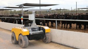
Source: (McMeniman, 2021)
The selected feed management technology described in this section demonstrates the complex variation of emerging technologies in the cattle feeding management sector. Although these new technologies have captured the interest of producers, product uptake will be heavily dependent upon the product’s value proposition and, ultimately, what value cattle producers put on circumventing labor challenges that plague the industry.
Developer considerations for end-user of emerging technology
This chapter highlights emerging technologies in the agriculture industry with connections to space. Although there is no doubt developers are busy innovating in this space, uptake by producers is not consistent across technology types. Automated technologies have shown sooner adoption by food producers after coming to the commercial market than more data-intensive technologies (Ofori, 2020). But data-intensive technologies are the lifeblood of larger applications such as VRT. Uptake of VRT by producers is estimated between 20-30% of American food producers – demonstrating interest on the part of the producer but that perhaps the technology has not yet fully found its value proposition for the food producer (Lowenberg‐Deboer, 2019). Value to the producer will always be pivotal to the success of emerging technologies in the agriculture industry. Increasing the quality and/or quantity of food products produced equates to more revenue from food producers. As emerging space technologies continue to navigate the challenges facing the modern agriculture industry, there is no doubt these innovations will profoundly impact the quality and quantity of food producers for the growing population.
Conclusions
As the age of smart agriculture ensues, the toolbox of emerging space technologies appears to be at the cutting edge of industry advancement. The advancing global population, increasing environmental challenges, and (relatively) static tillable acres presents the industry with innovation opportunities to shoot for the stars in an effort to keep up with demand for increased food production. The examples demonstrated in this chapter have provided evidence that original innovators of space technologies may have rarely had the chance to put their theories into agricultural practice themselves; but from the perspective of the agricultural sector, those technologies have the ability to change lives by increasing the quantity and quality of food this world can produce.
References
Armstrong, R. (2016). Quantified Ag’s LED tags light up to identify sick cattle. . Retrieved from https://siliconprairienews.com/: https://siliconprairienews.com/2016/08/quantified-ag-led-tags-light-up-identify-sick-cattle/
Bacon, S. (2022). Reading the signs: Annual agricultural symposium examines effect of labor shortages on long-term outlook. Ten Magazine, pp. 18(1), 28 – 34. doi:https://www.kansascityfed.org/TEN/documents/8874/ten_summer2022.pdf
Bansod, B., & Singh, R. T. (2017). A comparison between satellite-based and drone-based remote sensing technology to achieve sustainable development: a review. Journal of Agriculture and Environment for International Development, 11(2), 383-407. doi:https://doi.org/10.12895/jaeid.20172.690
Castillejo-González, I. L.-G.-F.-B.-E.-A. (2009). Object- and pixel-based analysis for mapping crops and their agro-environmental associated measures using QuickBird imagery. Computers and electronics in agriculture., 68(2), 207. doi:https://doi.org/10.1016/j.compag.2009.06.004
Comparetti, A. &. (2022). Use of Sentinel-2 Satellite for Spatially Variable Rate Fertiliser Management in a Sicilian Vineyard. Sustainability, 14(3), 1688. doi:https://doi.org/10.3390/su14031688
Donoghue, D. W. (2007). Remote sensing of species mixtures in conifer plantations using LiDAR height and intensity data. Remote sensing of environment, 110(4), 509-522. doi:https://doi.org/10.1016/j.rse.2007.02.032
Doraiswamy, P. C., & Moulin, S. C. (2003). Crop Yield Assessment from Remote Sensing. . Photogrammetric Engineering & Remote Sensing, pp. 69(6), 665-674. . doi:https://doi.org/10.14358/pers.69.6.665
Dorea, J. R. (2019). PSXI-2 A computer vision system for feed bunk management in beef cattle feedlot. Journal of animal science., 97(Supplement_3), 389-390. doi:https://doi.org/10.1093/jas/skz258.776
Dutta, D. N. (2022). MOOnitor: An IoT-based multisensory intelligent device for cattle activity monitoring. Sensors and actuators, 333, 113271. doi:https://doi.org/10.1016/j.sna.2021.113271
Enclona, E. A. (2004). Within-field wheat yield prediction from IKONOS data: a new matrix approach. International journal of remote sensing, 25(2), 377-388. doi:https://doi.org/10.1080/0143116031000102485
Fox, C. (2019). Dairymaster MooMonitor+ first in class for monitoring cow behavior. Farming Independent . doi:https://www.independent.ie/business/farming/agri-business/companies/dairymaster-moomonitor-first-in-class-for-monitoring-cow-behavior-38095157.html
Goel, R. K., & Yadav, C. S. (2021). Smart agriculture – Urgent need of the day in developing countries. Sustainable Computing: Informatics and Systems, 30, 100512. doi:https://doi.org/10.1016/j.suscom.2021.100512
Gómez-Casero, M. T., & Castillejo-González, I. L.-F.-B.-E.-T.-G. (2010). Spectral discrimination of wild oat and canary grass in wheat fields for less herbicide application. Agronomy for Sustainable Development, 30(3), 689-699. doi:https://doi.org/10.1051/agro/2009052
Hafeez, A. H. (2022). Implementation of drone technology for farm monitoring & pesticide spraying: A review. Information Processing in Agriculture. doi:https://doi.org/10.1016/j.inpa.2022.02.002
Handcock, R. S.-H. (2009). Monitoring Animal Behaviour and Environmental Interactions Using Wireless Sensor Networks, GPS Collars, and Satellite Remote Sensing. Sensors, 9(5), 3586-3603. . doi:https://doi.org/10.3390/s90503586
Horton, C. V. (2019). Patent No. Agricultural drone for use in livestock feeding. In: Google Patents.
John Deere. (2022). John Deere Mobile Weather. John Deere.
Llopis-Jepsen, C. (2022). How Satellite-Guided Cows Might Save the Kansas Prairie and Make Ranchers More Money . Retrieved from ksnewsservice.org: ksnewsservice.org
Lowenberg‐Deboer, J. &. (2019). Setting the Record Straight on Precision Agriculture Adoption. Agronomy Journal, 111(4), 1552-1569. . doi:https://doi.org/10.2134/agronj2018.12.0779
Mader, T. L.-B. (2006). Environmental factors influencing heat stress in feedlot cattle1,2. . Journal of Animal Science, 84(3), 712-719. doi:https://doi.org/10.2527/2006.843712x
Mallarino, A. P. (2010). Crop Yield and Soil Phosphorus as Affected by Liquid Swine Manure Phosphorus Application Using Variable-Rate Technology. Soil Science Society of America Journal, 74(6), 2230-2238. . doi:https://doi.org/10.2136/sssaj2009
Maresma, Á., & Ariza, M. M.-C. (2016). Analysis of Vegetation Indices to Determine Nitrogen Application and Yield Prediction in Maize (Zea mays L.) from a Standard UAV Service. Remote Sensing, 8(12), 973. doi:https://doi.org/10.3390/rs8120973
McMeniman, J. (2021). BunkBot adoption demonstrations begin. Retrieved from Meat & Livestock Australia: https://www.mla.com.au/news-and-events/industry-news/bunkbot-adoption-demonstrations-begin/#:~:text=An%20integrated%20system%20developed%20by,accurate%20and%20precise%20than%20humans.
Meyers, J. M., & Dokoozlian, N. R. (2020). A New, Satellite NDVI-Based Sampling Protocol for Grape Maturation Monitoring. Remote Sensing, 12(7), 1159. . doi:https://doi.org/10.3390/rs12071159
Micro Technologies: Our History – Innovation in Motion. . (2022). Micro Technologies Amerisource Bergen. .
Ofori, E. G. (2020). Duration analyses of precision agriculture technology adoption: what’s influencing farmers’ time-to-adoption decisions? Agricultural finance review., 80(5), 647-664. https://doi.org/10.1108/AFR-11-2019-0121. Agricultural finance review., 80(5), 647-664. . doi:https://doi.org/10.1108/AFR-11-2019-0121
Pearson, C. F. (2021). The Relationship between Satellite-Derived Vegetation Indices and Live Weight Changes of Beef Cattle in Extensive Grazing Conditions. Remote Sensing, 13(20), 4132. . doi:https://doi.org/10.3390/rs13204132
Peña-Barragán, J. M.-G.-T.-E.-F. (2008). Discriminating cropping systems and agro-environmental measures by remote sensing. Agronomy for Sustainable Development, 28(2), 355-362. doi:https://doi.org/10.1051/agro:2007049
Reynolds, B. R. (2022). PrecisionVision 35 X Unmanned aircraft system (UAS). Retrieved from https://leaaerialtech.com/precisionvision-35x/: https://leaaerialtech.com/precisionvision-35x/
Sciforce. (2020). Smart Farming: The Future of Agriculture. IoT for all. Retrieved from https://www.iotforall.com/: Sciforce. (2020). Smart Farming: The Future of Agriculture. IoT for all. https://www.iotforall.com/smart-farming-future-of-agriculture
Sullivan, D. G., & Shaw, J. N. (2005). IKONOS Imagery to Estimate Surface Soil Property Variability in Two Alabama Physiographies. . Soil Science Society of America Journal, 69(6), 1789-1798. doi:https://doi.org/10.2136/sssaj2005.0071
Timmermans, R. (2022). 4 New Technologies in Agriculture That Are Helping Farmers. Groundstation. Retrieved from www.groundstation.space: https://www.groundstation.space/4-new-technologies-in-agriculture-that-are-helping-farmers/
Ungar, E. D., & Henkin, Z. G. (2005). Inference of Animal Activity From GPS Collar Data on Free-Ranging Cattle. Rangeland ecology & management., 58(3), 256-266. doi:https://doi.org/10.2111/1551-5028(2005)58[256:IOAAFG]2.0.CO;2
United States Environmental Protection Agency. (2022, June 13). Laws and Regulations that Apply to Your Agricultural Operation by Farm Activity. Retrieved from https://www.epa.gov/: https://www.epa.gov/agriculture/laws-and-regulations-apply-your-agricultural-operation-farm-activity
United States Environmental Protection Agency. (2022, August 23). EPA Unmanned Aircraft Systems (UAS) Program. Retrieved from www.epa.gov/: https://www.epa.gov/geospatial/epa-unmanned-aircraft-systems-uas-program
Vaeljaots, E. L. (2018). Soil sampling automation case-study using unmanned ground vehicle. . Eng. Rural Dev, pp. 17, 982-987. .
Veres, B. &. (2022). Insight into emerging space system technologies on the market for cattle management applications . (D. H. Larson, Interviewer)
Wang, S. R. (2022, Feb). “Farm Labor, Human Capital, and Agricultural Productivity in the United States,” ERR-302, U.S. Department of Agriculture, Economic Research Service. Retrieved from https://www.ers.usda.gov/: https://www.ers.usda.gov/authors/ers-staff-directory/sun-ling-wang/
Wankhede, S. J. (2021). Agricultural Drones Market by Offering, Component, and Application: Opportunity Analysis and Industry Forecast 2021-2030. (A04722), 286. doi:https://www.alliedmarketresearch.com/agricultural-drone-market
Yang, C. &. (2020). Mapping Grain Sorghum Yield Variability Using Airborne Digital Videography. . Precision Agriculture, pp. 2(1), 7-23. . doi:https://doi.org/10.1023/a:1009928431735
Zarco-Tejada, P. J.-D. (2012). Fluorescence, temperature and narrow-band indices acquired from a UAV platform for water stress detection using a micro-hyperspectral imager and a thermal camera. Remote sensing of environment, 117, 322-337. . doi:https://doi.org/10.1016/j.rse.2011.10.007
